Line stations
| | This section is empty. You can help by adding to it. (February 2019) |
There are numerous telegraph stations that have been important individually in the history of Australia, the United States, and other countries, and there are systems of telegraph stations that have collectively been important during the 19th century and early 20th century. In 1853, it was asserted that there were 4,000 miles of telegraph lines in Great Britain, 27,000 miles in the United States, and it was expected that 4,000 miles of telegraph lines would soon be built in India. [1] The telegraph lines required repeater stations and/or repair stations. In addition to stations along traditional telegraph lines, there were also a number of notable wireless telegraph stations that were important for communication to and from ships.
| | This section is empty. You can help by adding to it. (February 2019) |
Charles B. Barr published in 1853 a map of telegraph stations "in the United States, the Canadas, and Nova Scotia" which showed stations in Canada West, Canada East, Prince Edward Island, New Brunswick, and Nova Scotia. [1]
Disturnell's 1851 map of canals, railways, telegraph lines, and stagecoach lines, shows similar detail in Canada and in the United States. [7]
| | This section is empty. You can help by adding to it. (February 2019) |
A list of telegraph stations in the United Kingdom was compiled irregularly, including in 1876, 1882, 1885, and 1889. [8]
| | This section is empty. You can help by adding to it. (February 2019) |
Charles B. Barr's 1853 map of telegraph stations "in the United States, the Canadas, and Nova Scotia" showed telegraph lines extending to the west in the U.S. as far as Alexandria, Louisiana, St. Joseph, Missouri, Muscatine, Iowa and Prairie du Chien, Wisconsin. [1] Disturnell's 1851 map of canals, railways, telegraph lines, and stagecoach lines, shows similar detail in the United States and in Canada. [7]
The First Transcontinental Telegraph was a telegraph line completed in 1861 that joined the eastern United States to California. It supplanted the Pony Express. It was authorized by the Pacific Telegraph Act of 1860.
The Deutschland incident (1902) illustrated the value and issues with wireless telegraph stations.
A 1908 publication by the U.S. Department of the Navy listed on-shore and off-shore wireless telegraph stations of the world. It included a list of shore stations of the world (by country), a list of merchant vessels (by ship line), as well as United States Army, United States Navy, and United States Revenue Cutter Service stations and vessels. [9] The publication was revised and reissued in 1910 and 1912.
Present-day telecommunications in Canada include telephone, radio, television, and internet usage. In the past, telecommunications included telegraphy available through Canadian Pacific and Canadian National.

Cape Breton Island is a rugged and irregularly shaped island on the Atlantic coast of North America and part of the province of Nova Scotia, Canada.

Guglielmo Giovanni Maria Marconi, 1st Marquis of Marconi was an Italian inventor and electrical engineer, known for his creation of a practical radio wave–based wireless telegraph system. This led to Marconi being credited as the inventor of radio, and he shared the 1909 Nobel Prize in Physics with Karl Ferdinand Braun "in recognition of their contributions to the development of wireless telegraphy".
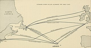
TAT-1 was the first submarine transatlantic telephone cable system. It was laid between Kerrera, Oban, Scotland and Clarenville, Newfoundland. Two cables were laid between 1955 and 1956 with one cable for each direction. It was inaugurated on September 25, 1956. The cable was able to carry 35 simultaneous telephone calls. A 36th channel was used to carry up to 22 telegraph lines.

Pugwash is an incorporated village in Cumberland County, Nova Scotia, Canada, located on the Northumberland Strait at the mouth of the Pugwash River. It had a population of 746 as of the 2021 census. The name Pugwash is derived from the Mi'kmaq word Pakwesk, meaning "a shoal", in reference to a reef near the mouth of the harbour.

Events from the year 1907 in Canada.

Machias Seal Island is an island in disputed water between the Gulf of Maine and the Bay of Fundy, about 16 km (10 mi) southeast from Cutler, Maine, and 19 km (12 mi) southwest of Grand Manan Island, New Brunswick. Sovereignty of the island is disputed by the United States and Canada. The Canadian Coast Guard continues to staff a lighthouse on the island; the first lighthouse was constructed there in 1832.
CJCB-DT is a television station in Sydney, Nova Scotia, Canada, part of the CTV Television Network. Owned and operated by network parent Bell Media, the station maintains studios on George Street/Trunk 22 in Sydney, and its transmitter is located on McMillan Road southwest of the city.

A cable layer or cable ship is a deep-sea vessel designed and used to lay underwater cables for telecommunications, for electric power transmission, military, or other purposes. Cable ships are distinguished by large cable sheaves for guiding cable over bow or stern or both. Bow sheaves, some very large, were characteristic of all cable ships in the past, but newer ships are tending toward having stern sheaves only, as seen in the photo of CS Cable Innovator at the Port of Astoria on this page. The names of cable ships are often preceded by "C.S." as in CS Long Lines.
Eastlink is the operating name of Bragg Communications Inc., a Canadian cable television and telecommunications company. The privately held company was founded in Nova Scotia in 1969 by the Bragg family, and has grown since through the amalgamation of several telecommunications companies.
Route 318 is a collector road in the Canadian province of Nova Scotia.
Scouting in Nova Scotia has a long history, from 1908 to the present day. There is early record of Boys' Brigade scouts, Canadian Boy Scouts and Salvation Army's Life-Saving Scouts in Nova Scotia. Scouting in Nova Scotia is currently conducted by local Scout groups and various associations including Scouts Canada, L'Association des Scouts du Canada and Canadian Federation of Independent Scouts affiliates such as BPSA - Nova Scotia.

Route 302 is a collector road in the Canadian province of Nova Scotia.

Wood Islands is a rural farming and fishing community located in southeastern Queens County, Prince Edward Island on the Northumberland Strait. It takes its name from several small forested islands, then located several hundred metres offshore in the Northumberland Strait. The community of Wood Islands falls within the larger PEI Township of Lot 62, which had a population in 2011 of 470 residents, a 13% decrease from the 2006 census count of 540. While the named islands are located on maps by Jacques-Nicolas Bellin: Karte Bellin, 1744: 'I a Bova' and Louis Franquet: Cartes Franquet, 1751: 'Isle a Bois', it was Samuel Johannes Holland who correctly surveyed and depicted the islands, about their basin. The 'European' settlement of Wood Islands began in 1803, but saw its most noted arrivals in 1807 with the arrival, after wintering in Pinette, of a large party of Scottish settlers from the Spencer.
Grandique Ferry is a former community in Richmond County, Nova Scotia.
Port Morien is a small fishing community of 700 people in the Canadian province of Nova Scotia, located in the southeastern Cape Breton Island near the rural community Donkin, and six miles from the town of Glace Bay.

Lophiola is a genus of monocotyledonous flowering plants native to eastern North America. It has variously been placed in the Liliaceae, the Haemodoraceae, the Tecophilaeaceae or the Nartheciaceae.

Lennox Passage Provincial Park is a small picnic and beach park on the shores of Lennox Passage on the North Shore of Isle Madame on Cape Breton Island, Nova Scotia, with 2 kilometres (1.2 mi) of shoreline, an operating lighthouse and site of a former post office, ferry terminal and two limestone quarries. Visitors can picnic at tables scattered through a forest and open areas, enjoy the 2 kilometres (1.2 mi) of trails, or explore the working lighthouse. In summer the park offers swimming, kayaking, and biking opportunities. There are snowshoeing and cross-country skiing opportunities in the winter, however parking is available at the gate only in the off-season.

Camperdown Signal Station, also known as Camperdown Hill, is significant in Nova Scotia communication history. Overlooking the entrance to Halifax Harbour made it a strategic part of Halifax's defence system in the 18th century. The hill has been used as a customs lookout, signal and telegraph station, observation post and redoubt commanding the Citadel Hill defence complex. The Camperdown Signal Station was built a few miles northward next to nearby Portuguese Cove in 1797, the first of a series of signal stations built by Prince Edward, Duke of Kent. It later became a wireless station and was operational until 1925. The military took over operating the station and it became known as VCS from 1935 until 1970.