References
| Countries | 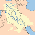 | |
|---|---|---|
| Cities | ||
| Tributaries |
| |
| Dams | ||
This is a list of tributaries of the Tigris by order of entrance.
The Tigris originates in Turkey, forms a part of the borders of Turkey-Syria and flows through Iraq. It joins the Euphrates forming Shatt al-Arab, which empties into the Persian Gulf.
| River | Entering the Tigris at | Distance from mouth | Side of the entrance | Length |
|---|---|---|---|---|
| Devegeçidi | right | |||
| Havar | ||||
| Yenice | ||||
| Karasu | ||||
| Ambar | Ambar, Diyarbakır, Turkey | left | ||
| Kuru | ||||
| Pamuk | left | |||
| Salat | ||||
| Batman | Oymataş, Batman, Turkey | left | 115 km (71 mi) | |
| Garzan | 150 km (93 mi) [1] | |||
| Göksu | right | |||
| Savur | right | |||
| Botan | Çattepe, Siirt, Turkey | left | ||
| Little Khabur | tripoint between Turkey, Syria and Iraq | |||
| Great Zab | Calah, Iraq | left | 426 km (265 mi) | |
| Little Zab | Baiji, Iraq | left | 402 km (250 mi) | |
| ‛Adhaim | left | |||
| Diyala | below Baghdad, Iraq | left | 445 km (277 mi) |
| Countries | | |
|---|---|---|
| Cities | ||
| Tributaries |
| |
| Dams | ||