Batman River

Last updated
Batman River
BatmanDam-July2012-01.JPG
Batman River Dam
Bassin Tigre Euphrate.jpg
Location
Country Turkey
Physical characteristics
Mouth  
  location
Tigris (Dicle)
Length115 km (71 mi) [1]

The Batman River is a major tributary of the Tigris in southeast Turkey. The region along the Batman River is known for its oil fields.

Contents

Course

The river originates in Turkey's Anti-Taurus Mountains (at the Sason and Genç mountains) [2] and flows approximately from north to south, passing near the city of Batman and forming a natural border between the Batman Province and Diyarbakır Province. The historic Malabadi Bridge (built in 1146–1147) crosses the river near the town of Silvan. [3]

The river is widest at about 100 metres (330 ft) right after exiting the dam, but then narrows to about 50 metres (160 ft) and forms numerous splits along its way to the Tigris. Its riverbed is irregular in many places, promoting flooding. A tributary of Batman, the Iluh River, originates in the Raman Mountain on the south of the Batman city and flows north-west through the city into the Batman River. Despite being a small river, absent on most maps, Iluh plays an important role for the province because its spring floods affect the provincial capital. The floods of Iluh and Batman rivers occur between March and May and sometimes in October or November. Major floods occurred in 1969 (April, 60 buildings damaged), 1972 (April and May, 210 buildings damaged), 1991 (November, 500 buildings flooded), 1995 (March, nearly 1000 buildings submerged and 450 damaged) and 2006 (October, 11 people died and 20 injured). [2]

Name

In Antiquity, the Batman River was known as Kalat. This name meant "bride" to the Syriac people who populated the area, and was translated into Greek as Nymphios (Νυμφίος, Latinized Nymphius) and Nymphaios (Νυμφαῖος, Latinized Nymphaeus). [4] Among Arabs it was known as Satidama, meaning "the bloody" reflecting the battles fought near it. [5]

In international literature, the name Batman came into use in the 19th century, [6] whereas in the 18th century and before it was mostly referred to as Nymphius, among other names. [7] [8] [9] The origin of the name "Batman" is unclear: it might be a shortening of the name of the 1,228-metre (4,029 ft) tall Bati Raman mountain located nearby [10] or refer to the unit of weight used in the Ottoman Empire.

History

The river served as a natural border between the Byzantine Empire and Sassanid Persia and saw major battles in 583 and 591 AD. The main citadel on the river was Martyropolis, modern-day Silvan. [11] [12]

The Batman Dam (Turkish : Batman Barajı, B. de Batman on the map) was built in 1999 in the upstream ( 38°09′36″N41°12′06″E / 38.160088°N 41.201574°E / 38.160088; 41.201574 ), together with the associated reservoir and hydroelectric power plant. [13] [14]

Wildlife

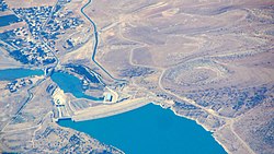
The Batman River loach (Paraschistura chrysicristinae) is a critically endangered fish native to the Batman and Ambar rivers. The fish is endangered by drought, habitat destruction, and habitat fragmentation from construction of the Batman Dam. It had not been observed since 1974 and was feared to be extinct until a 2021 expedition netted 14 fish living above the Batman Dam. [15]

Related Research Articles

<span class="mw-page-title-main">Euphrates</span> River in Turkey, Iraq, and Syria

The Euphrates is the longest and one of the most historically important rivers of Western Asia. Together with the Tigris, it is one of the two defining rivers of Mesopotamia. Originating in Turkey, the Euphrates flows through Syria and Iraq to join the Tigris in the Shatt al-Arab in Iraq, which empties into the Persian Gulf.

<span class="mw-page-title-main">Tigris</span> River in Turkey, Iraq, and Syria

The Tigris is the eastern of the two great rivers that define Mesopotamia, the other being the Euphrates. The river flows south from the mountains of the Armenian Highlands through the Syrian and Arabian Deserts, and empties into the Persian Gulf.

<span class="mw-page-title-main">Batman, Turkey</span> Municipality in Batman, Turkey

Batman is a city and capital of Batman District in Batman Province, Turkey. It lies on a plateau, 540 meters above sea level, near the confluence of the Batman River and the Tigris and had a population of 452,157 in 2021. It is populated by Kurds.

<span class="mw-page-title-main">Anabasis (Xenophon)</span> Work by Xenophon

Anabasis is the most famous work of the Ancient Greek professional soldier and writer Xenophon. It gives an account of the expedition of the Ten Thousand, an army of Greek mercenaries hired by Cyrus the Younger to help him seize the throne of Persia from his brother, Artaxerxes II, in 401 BC.

<span class="mw-page-title-main">Tigris–Euphrates river system</span> River system in the Middle East

The Tigris–Euphrates river system is a large river system in Western Asia that discharges into the Persian Gulf. Its principal rivers are the Tigris and Euphrates, along with smaller tributaries.

<span class="mw-page-title-main">Batman Province</span> Province in Turkey

Batman Province is a province in Turkey. It was created in May 1990 with the Law No. 3647 taking some parts from the eastern Province of Siirt and some from the southern Province of Mardin. Its area is 4,477 km2, and its population is 634,491 (2022). Its current governor is Ekrem Canalp.

<span class="mw-page-title-main">Taurus Mountains</span> Mountain range in southern Turkey

The Taurus Mountains are a mountain complex in southern Turkey, separating the Mediterranean coastal region from the central Anatolian Plateau. The system extends along a curve from Lake Eğirdir in the west to the upper reaches of the Euphrates and Tigris rivers in the east. It is a part of the Alpide belt in Eurasia.

<span class="mw-page-title-main">Büyük Menderes River</span> River in Turkey

The Büyük Menderes River, is a river in southwestern Turkey. It rises in west central Turkey near Dinar before flowing west through the Büyük Menderes graben until reaching the Aegean Sea in the proximity of the ancient Ionian city Miletus. The river was well known for its sinuous, curving pattern, and gives its name to the common term used to describe these characteristic bends in rivers.

<span class="mw-page-title-main">Ilısu Dam</span> Dam in Mardin Province, Turkey

The Ilısu Dam is a concrete-face rock-fill dam on the Tigris near the village of Ilısu and along the border of Mardin and Şırnak Provinces in Turkey. It is one of the 22 dams of the Southeastern Anatolia Project and its purpose is hydroelectric power production, flood control and water storage. When operational, the dam will support a 1,200 MW power station and will form a 10.4 billion m3 reservoir. Construction of the dam began in 2006 and was originally expected to be completed by 2016. As part of the project, the much smaller Cizre Dam is to be constructed downstream for irrigation and power. The dam has drawn international controversy, because it will flood portions of ancient Hasankeyf and necessitate the relocation of people living in the region. Because of this, the dam lost international funding in 2008. Most historical structures in Hasankeyf were moved to the new Hasankeyf prior to the filling of the dam. The dam began to fill its reservoir in late July 2019. Due to rainfall, the dam has achieved water levels up to 100m above the river bed and stored 5 billion cubic meters of water. The water level had reached an elevation of 498.2m on 1 April 2020.

Thapsacus was an ancient town along the western bank of the Euphrates river that would now lie in modern Syria. Thapsacus was the Greek and Roman name for the town. The town was important and prosperous due to its river crossing, which allowed east-west land traffic to pass through it. Its precise location is unknown and there are several different locations identified as the site of Thapsacus. One possibility is a location close to Carchemish, which now lies in Turkey, on its border with Syria. Karkamış and Jarabulus are the closest modern towns in Turkey and Syria respectively. More recently it has been suggested that Thapsacus was renamed to Seleucia at the Zeugma, which lies further upstream on the Euphrates.

<span class="mw-page-title-main">Hasankeyf</span> Municipality in Batman, Turkey

Hasankeyf is a town located along the Tigris, in the Hasankeyf District, Batman Province, Turkey. It was declared a natural conservation area by Turkey in 1981.

<span class="mw-page-title-main">Great Zab</span> River in Iraq and Turkey

The Great Zab or Upper Zab is an approximately 400-kilometre (250 mi) long river flowing through Turkey and Iraq. It rises in Turkey near Lake Van and joins the Tigris in Iraq south of Mosul. During its course, the river collects water from many tributaries and the drainage basin of the Great Zab covers approximately 40,300 square kilometres (15,600 sq mi). The river and its tributaries are primarily fed by rainfall and snowmelt – as a result of which discharge fluctuates highly throughout the year. At least six dams have been planned on the Great Zab and its tributaries, but construction of only one, the Bekhme Dam, has commenced but was halted after the Gulf War.

<span class="mw-page-title-main">Corduene</span> Ancient region south of Lake Van, Turkey

Corduene was an ancient historical region, located south of Lake Van, present-day eastern Turkey.

<span class="mw-page-title-main">Darende</span> District and municipality in Malatya, Turkey

Darende is a municipality and district of Malatya Province, Turkey. Its area is 1,482 km2, and its population is 24,588 (2022). It lies 46 miles (74 km) to the northwest of Malatya, 87 miles (140 km) south of Sivas, 110 miles (180 km) east of Kayseri.

<span class="mw-page-title-main">Seyhan River</span> River in Cilicia, Turkey

The Seyhan River, alternatively known as Sarus, is the longest river of Cilicia and the longest of Turkey that flows into the Mediterranean Sea. The river is 560 km and flows southwest from its headwaters in the Tahtalı-Mountains in the Anti-Taurus Mountains to the Mediterranean Sea via a broad delta. Its main tributaries are Zamantı and Göksu, which unite in Aladağ, Adana to form the Seyhan River. The Zamantı River originates from the Uzun Plateau in Pınarbaşı, Kayseri and crosses Tomarza, Develi and Yahyalı districts in Kayseri.

<span class="mw-page-title-main">State Hydraulic Works (Turkey)</span> Government agency of Turkey

The State Hydraulic Works is a state agency, under the Ministry of Environment and Forestry of Turkey, responsible for the utilization of all the country's water resources. The institution's four major functions are energy, agriculture, services and environment. The General Manager of DSI is Kaya Yıldız.

Ergenekon is a founding myth of Turkic and Mongolic peoples.

<span class="mw-page-title-main">Botan River</span> River in Siirt, Turkey

The Botan River is located in the Siirt Province of southeastern Turkey. The upstream of the Botan River is often called Çatak, which flows mostly in the Van Province.

<span class="mw-page-title-main">Old Bridge, Hasankeyf</span> Bridge in Eastern Anatolia Region, Turkey

The Old Bridge, also known as the Old Tigris Bridge, is a ruined four-arch bridge spanning the Tigris River in the town of Hasankeyf in Batman Province in southeastern Turkey. It was built by the Artuqid Turkmens in the mid-12th century, between about 1147 and 1167, and at the time its central arch was one of the largest in the world, if not the largest. The bridge was repaired by Ayyubid Kurdish and Aq Qoyunlu Turkmen rulers during the 14th and 15th centuries and appears to have eventually collapsed in the early or mid-17th century. The bridge's ruined piers still stand, as does one arch. Since 2020 the ruins of the bridge, along with most of the town of Hasankeyf, have been submerged underwater by the filling of the Ilısu Dam reservoir.

The Carduchii or Karduchoi were a group of warlike tribes that inhabited an area stretching from the Botan River in the south to an area north of Cizre in present-day Turkey. Sometime after 401 BC, they expanded their authority into the northern Tigris valley. Between 165–95 BC, they established the independent kingdom of Gordyene, seemingly as a result of the power vacuum that took place following the weakening of the Greek Seleucid Empire.

References

  1. Batman Genel Bilgileri Archived May 20, 2011, at the Wayback Machine (Batman General Information), batman.gov.tr, 29.08.2008 (in Turkish)
  2. 1 2 Balaban, Meltem Şenol Risk society and planning: the case of flood disaster management in turkish cities. PhD Thesis. Graduate School of Natural and Applied sciences, Middle East Technical University 2009, pp. 147–149, 157
  3. Batman. Coğrafya Archived 2012-09-12 at the Wayback Machine , kultur.gov.tr, 21 February 2007 (in Turkish)
  4. Two essays on the geography of ancient Asia: intended partly to illustrate the campaigns of Alexander, and the Anabasis of Xenophon. J. Murray. 1829. pp.  277–.
  5. Walter Emil Kaegi (2003). Heraclius: emperor of Byzantium. Cambridge University Press. pp. 131–. ISBN   978-0-521-81459-1.
  6. Two essays on the geography of ancient Asia: intended partly to illustrate the campaigns of Alexander, and the Anabasis of Xenophon. J. Murray. 1829. pp.  262–.
  7. Alexander MacBean; Samuel Johnson (1773). A dictionary of ancient geography: explaining the local appellations in sacred, Grecian, and Roman history; exhibiting the extent of kingdoms, and situations of cities, &c. And illustrating the allusions and epithets in the Greek and Roman poets. The whole established by proper authorities, and designed for the use of schools. G. Robinson. pp. 387–.
  8. George Sale; George Psalmanazar; Archibald Bower; George Shelvocke; John Campbell; John Swinton (1748). An Universal history, from the earliest account of time. Printed for T. Osborne. pp. 618–.
  9. Christoph Cellarius (1706). Notitia orbis antiqui, sive Geographia plenior, ab ortu rerumpublicarum ad Constantinorum tempora. pp. 453–.
  10. Ankara Üniversitesi. Tarih Araştırmaları Enstitüsü (1982). Tarih araştırmaları dergisi. Ankara Üniversitesi Basımevi. p. 415. Retrieved 11 February 2011.
  11. Gordon Douglas Young; American Oriental Society. Middle West Branch; Society of Biblical Literature. Mid-West Region (1992). Mari in retrospect: fifty years of Mari and Mari studies. Eisenbrauns. pp. 10–. ISBN   978-0-931464-28-7.
  12. "Nymphius (Batman)". Archived from the original on 2012-12-29. Retrieved 2020-03-26.
  13. Batman Dam. structurae.de
  14. Batman Dam Archived July 2, 2014, at the Wayback Machine . General Directorate of State Hydraulic Works, Turkey
  15. Greene, Graeme (2021) "Batman loach returns: fish feared extinct found in Turkey". The Guardian 9 December 2021.

37°47′N41°01′E / 37.783°N 41.017°E / 37.783; 41.017