This is a list of lists of hills. A hill is a landform that extends above the surrounding terrain.

This is a list of lists of hills. A hill is a landform that extends above the surrounding terrain.
Pike, Pikes or The Pike may refer to:
Hermitage, The Hermitage or L'Hermitage may refer to:

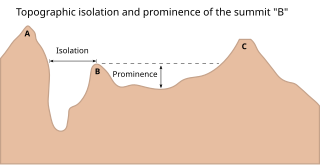
In topography, prominence or relative height measures the height of a mountain or hill's summit relative to the lowest contour line encircling it but containing no higher summit within it. It is a measure of the independence of a summit. The key col ("saddle") around the peak is a unique point on this contour line and the parent peak is some higher mountain, selected according to various criteria.

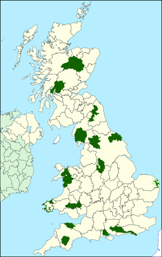
National parks of the United Kingdom are 15 areas of relatively undeveloped and scenic landscape across the country. Despite their name, they are quite different from national parks in many other countries, which are usually owned and managed by governments as protected community resources, and which do not usually include permanent human communities. In the United Kingdom, an area designated as a national park may include substantial settlements and human land uses that are often integral parts of the landscape. Land within national parks remains largely in private ownership. These parks are therefore not "national parks" according to the internationally accepted standard of the IUCN but they are areas of outstanding landscape where planning controls are a little more restrictive than elsewhere.

Battle is a town and civil parish in the district of Rother in East Sussex, England. It lies 50 miles (80 km) south-east of London, 27 miles (43 km) east of Brighton and 20 miles (32 km) east of Lewes. Hastings is to the south-east and Bexhill-on-Sea to the south. Battle is in the designated High Weald Area of Outstanding Natural Beauty. The parish population was 6,673 according to the 2011 Census and 6,800 in the 2021 census. Battle contains the site of, and is named after, the Battle of Hastings, where William, Duke of Normandy, defeated King Harold II to become William I of England in 1066. For some 250 years after 1066, official documents referred to the town as (Latin) Bellum or (French) Bataille.
Blackwell may refer to:

Southwater is a large village and civil parish in the Horsham District of West Sussex, England, with a population of roughly 10,000. It is administered within Horsham District Council and West Sussex County Council.

Iford is a village and civil parish in the Lewes District of East Sussex, England. The village is located two miles (3.2 km) south of Lewes. The parish lies on the slopes of the South Downs in the valley of the River Ouse.

Chembra Peak is a mountain in the state of Kerala, India, with an elevation of 2,100 m (6,890 ft) above sea level. The highest peak in the Wayanad hills and one of the highest peaks in the Western Ghats, adjoining the Nilgiri Hills and Vellarimala, it is located in the Wayanad district of Kerala, near the town of Meppadi and 8 km (5 mi) south of Kalpetta.

The mountains and hills of the British Isles are categorised into various lists based on different combinations of elevation, prominence, and other criteria such as isolation. These lists are used for peak bagging, whereby hillwalkers attempt to reach all the summits on a given list, the oldest being the 282 Munros in Scotland, created in 1891.
Black Hill may refer to:

The mountains and hills of England comprise very different kinds of terrain, from a mountain range which reaches almost 1,000 metres high, to several smaller areas of lower mountains, foothills and sea cliffs. Most of the major upland areas have been designated as Areas of Outstanding Natural Beauty (AONB) or national parks. The highest and most extensive areas are in the north and west, while the midlands, south-east and east of the country tend to be low-lying.