List of hills
| Hill | Height (m) | Prom. (m) | Grid ref. | Class | Parent | Range/Region | Remarks | Image |
|---|---|---|---|---|---|---|---|---|
| Brown Willy [1] | 420 | 314 | SX158799 | Marilyn | High Willhays | Bodmin Moor | Cornwall's county top. Highest of Cornwall's 5 Marilyns. |  |
| Rough Tor [4] | 400 | 87 | SX145807 | TuMP | Brown Willy | Bodmin Moor | Bodmin Moor's second highest summit. Site of tor cairn and historic settlements and monuments. |  |
| Kilmar Tor [1] | 396 | 118 | SX252748 | HuMP | Brown Willy | Bodmin Moor | Tor 50m SW of summit trig point |  |
| Stowe's Hill [4] | 381 | 78 | SX257724 | TuMP | Brown Willy | Bodmin Moor | Massive tor enclosure (Stowe's Pound) and site of the Cheesewring |  |
| Langstone Downs [4] | 379 | 33 | SX255738 | TuMP | Brown Willy | Bodmin Moor | Large ancient cairn at summit. S of Kilmar Tor |  |
| Caradon Hill [4] | 371 | 69 | SX272707 | TuMP | Brown Willy | Bodmin Moor | Caradon Hill transmitting station, former mining area |  |
| The Beacon (Hendra Downs) [4] | 369 | 91 | SX196792 | TuMP, sub-HuMP | Brown Willy | Bodmin Moor | Outcrop near fence is the summit. |  |
| Tolborough Tor [4] | 348 | 42 | SX175778 | TuMP | Brown Willy | Bodmin Moor | Outcrop at the summit. |  |
| Bray Down [4] | 346 | 54 | SX189821 (est.) | TuMP | Brown Willy | Bodmin Moor | Small cheesewring at the summit. |  |
| Buttern Hill [4] | 346 | 48 | SX174816 | TuMP | Brown Willy | Bodmin Moor | Mound is near Bronze Age chamber tomb. |  |
| Newel Tor [4] | 346 | 62 | SX236741 | TuMP | Brown Willy | Bodmin Moor | Leaning rock slab at summit. |  |
| Brown Gelly [4] | 342 | 74 | SX196727 | TuMP | Brown Willy | Bodmin Moor | Tor, hut circles, barrows and cairns. |  |
| Kit Hill [1] | 334 | 171 | SX374713 | Marilyn | Brown Willy | Cornish Killas | One of Cornwall's five Marilyns Highest point in Cornwall outside Bodmin Moor |  |
| Ridge [4] | 331 | 44 | SX242777 | TuMP | Brown Willy | Bodmin Moor | Rock on south edge of summit plateau. | |
| Garrow Tor [4] | 330 | 57 | SX374713 | TuMP | Brown Willy | Bodmin Moor | Several tors and extensive Bronze Age and Medieval settlements, hut circles, etc. | 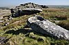 |
| Hawk's Tor, North Hill [4] | 329 | 36 | SX253763 | TuMP | Brown Willy | West Bodmin Moor | Rock tor at summit. No trig point. |  |
| Leskernick Hill [4] | 329 | 36 | SX183803 | TuMP | Brown Willy | Bodmin Moor | Summit is grassy mound near pool. |  |
| Fox Tor [4] | 323 | 35 | SX226785 | TuMP | Brown Willy | Bodmin Moor | Summit is a rocky tor, 20 metres SW of trig point. | 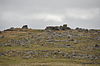 |
| Butter's Tor [4] | 316 | 34 | SX154783 | TuMP | Brown Willy | Bodmin Moor | Outcrop at summit. |  |
| Louden Hill [4] | 315 | 32 | SX137803 | TuMP | Brown Willy | Bodmin Moor | Flat granite plinth at summit. |  |
| Hensbarrow Beacon [1] | 312 | 193 | SW996575 | Marilyn | Brown Willy | Hensbarrow | One of Cornwall's five Marilyns Summit dominated by spoil heaps of china clay mine | |
| Condolden Barrow [4] | 308 | 50 | SX090872 | TuMP | Cornish Killas | Summit trig point, Bronze Age barrows Second highest point in Cornwall outside Bodmin Moor |  | |
| Hawk's Tor, Blisland [4] | 307 | 61 | SX143763 | TuMP | Brown Willy | East Bodmin Moor | Summit is the outcrop next to the trig point. Site of Stripple stones, stone circle, Hawkstor Pit SSSI |  |
| Brockabarrow Common [4] | 306 | 31 | SX160747 | TuMP | Brown Willy | Bodmin Moor | Pile of boulders at summit. |  |
| Alex Tor [4] | 291 | 30 | SX118787 | TuMP | Bodmin Moor | Summit tor cairn | 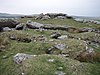 | |
| Hingston Down [4] | 268 | 47 | SX409714 (est.) | TuMP | Tamar Valley | There is a tumulus, a transmission tower and various buildings around the summit |  | |
| Carnmenellis [1] | 252 | 165 | SW695364 | Marilyn | Hensbarrow Beacon | Carnmenellis | One of Cornwall's five Marilyns Summit trig point | 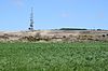 |
| Watch Croft [1] | 252 | 225 | SW420357 | Marilyn | Brown Willy | West Penwith | One of Cornwall's five Marilyns Trig point nr summit |  |
| Carn Marth [4] | 235 | 60 | SW715408 | TuMP | Carnmenellis | Site of former granite quarry |  | |
| Carn Brea [4] | 228 | 47 | SW683407 | TuMP | Carnmenellis | Neolithic and Iron Age settlement |  | |
| Castle Downs [5] | 216 | 67 | SW945623 | TuMP | Cornish Killas | Site of major Iron Age fort: Castle an Dinas |  | |
| Trink Hill [4] | 212 | 62 | SW504371 (est.) | TuMP | Watch Croft | West Penwith | Trig point and mound at summit. |  |
| Helman Tor [4] | 210 | 37 | SX062615 | TuMP | Hensbarrow | Tor, nature reserve, logan stone, prehistoric hillfort and stone hut circle |  | |
| Bin Down [1] | 203 | 101 | SX276578 | HuMP | Kilmar Tor | Cornish Killas | Tall man-made mound on summit On Looe Golf Course by 7th tee. | |
| Carn Kenidjack [6] | 202 | ~25 | SW388329 | Unclassified | West Penwith | Open hilltop, subpeak is Wheal Bal Hill with a transmission tower. | 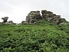 | |
| Chapel Carn Brea [5] [7] | 198 | 30 | SW386280 | TuMP | West Penwith | Hercynian granite outcrop; westernmost hill in Britain; site of old chapel, beacon. | 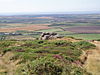 | |
| Tregonning Hill [1] | 194 | 102 | SW599300 | HuMP | Carnmenellis | Cornish Killas | Summit trig point |  |
| Prospidnick Hill [6] | 162 | ~10 | SW654312 | Unclassified | Cornish Killas | Open summit; wood on SW hillside. |  | |
| Brea Hill [4] | 62 | 41 | SW928771 | TuMP | Cornish Killas | Bronze Age tumuli at summit | 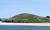 |
