
Bodmin Moor is a granite moorland in north-eastern Cornwall, England. It is 208 square kilometres (80 sq mi) in size, and dates from the Carboniferous period of geological history. It includes Brown Willy, the highest point in Cornwall, and Rough Tor, a slightly lower peak. Many of Cornwall's rivers have their sources here. It has been inhabited since at least the Neolithic era, when primitive farmers started clearing trees and farming the land. They left their megalithic monuments, hut circles and cairns, and the Bronze Age culture that followed left further cairns, and more stone circles and stone rows. By medieval and modern times, nearly all the forest was gone and livestock rearing predominated.
Cornwall is a historic county and ceremonial county in South West England. It is recognised as one of the Celtic nations, and is the homeland of the Cornish people. Cornwall is bordered to the north and west by the Atlantic Ocean, to the south by the English Channel, and to the east by the county of Devon, with the River Tamar forming the border between them. Cornwall forms the westernmost part of the South West Peninsula of the island of Great Britain. The southwesternmost point is Land's End and the southernmost Lizard Point. Cornwall has a population of 568,210 and an area of 3,563 km2 (1,376 sq mi). The county has been administered since 2009 by the unitary authority, Cornwall Council. The ceremonial county of Cornwall also includes the Isles of Scilly, which are administered separately. The administrative centre of Cornwall is Truro, its only city.

Camborne is a town in Cornwall, England. The population at the 2011 Census was 20,845. The northern edge of the parish includes a section of the South West Coast Path, Hell's Mouth and Deadman's Cove.

Towednack is a churchtown and civil parish in Cornwall, England, United Kingdom. The parish is bounded by those of Zennor in the west, Gulval in the south, Ludgvan in the west and south, and St Ives and the Atlantic Ocean in the north and east. The church is about two miles (3 km) from St Ives and six miles (10 km) from Penzance.
Killas is a Cornish mining term for metamorphic rock strata of sedimentary origin which were altered by heat from the intruded granites in the English counties of Devon and Cornwall. The term is used in both counties.
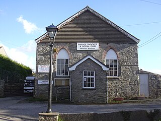
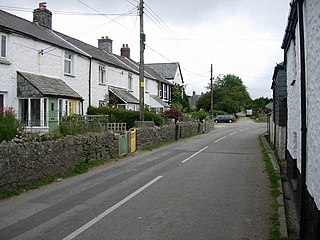
Breage is a civil parish and village in Cornwall, United Kingdom. The village is three miles (5 km) west of Helston.

Mining in Cornwall and Devon, in the southwest of England, began in the early Bronze Age, around 2150 BC. Tin, and later copper, were the most commonly extracted metals. Some tin mining continued long after the mining of other metals had become unprofitable, but ended in the late 20th century. In 2021, it was announced that a new mine was extracting battery-grade lithium carbonate, more than 20 years after the closure of the last South Crofty tin mine in Cornwall in 1998.

St Agnes is a civil parish and a large village on the north coast of Cornwall, UK. The village is about five miles (8 km) north of Redruth and ten miles (16 km) southwest of Newquay. An electoral ward exists stretching as far south as Blackwater. The population at the 2011 census was 7,565.
Prideaux Castle is a multivallate Iron Age hillfort situated atop a 133 m (435 ft) high conical hill near the southern boundary of the parish of Luxulyan, Cornwall, England, United Kingdom. It is also sometimes referred to as Prideaux Warren, Prideaux War-Ring, or Prideaux Hillfort. The site is a scheduled monument and so protected from unauthorised works by the Ancient Monuments and Archaeological Areas Act 1979.

The geology of Cornwall, England, is dominated by its granite backbone, part of the Cornubian batholith, formed during the Variscan orogeny. Around this is an extensive metamorphic aureole formed in the mainly Devonian slates that make up most of the rest of the county. There is an area of sandstone and shale of Carboniferous age in the north east, and the Lizard peninsula is formed of a rare section of uplifted oceanic crust.

St Breward is a civil parish and village in Cornwall, England, United Kingdom. It is on the western side of Bodmin Moor, about 6 miles (10 km) north of Bodmin. At the 2011 census the parish population including Cooksland and Fentonadle was 919.
Belowda is a village in Cornwall, England, UK. The village is just north of the A30 trunk road, about seven miles west-southwest of Bodmin. The village also gives its name to the nearby Belowda Beacon. It is in the civil parish of Roche.
Minions is a village in Cornwall, England, United Kingdom. It is situated on the eastern flank of Bodmin Moor northwest of Caradon Hill approximately four miles (6 km) north of Liskeard. Minions is first recorded in 1613 and its meaning is unknown.

Trencrom Hill is a prominent hill fort, owned by the National Trust, near Lelant, Cornwall. It is crowned by an univallate Neolithic tor enclosure and was re-used as a hillfort in the Iron Age. Cairns or hut circles can be seen in the level area enclosed by the stone and earth banks. The hill overlooks the Hayle Estuary and river, and Mount's Bay and St Michael's Mount can be seen to the south. The hill was recorded as Torcrobm in 1758 which is derived from Cornish "torr crobm", i.e. 'hunched bulge'.
Rinsey is a hamlet in Cornwall, England, United Kingdom. It is located off the main A394 road between Helston and Penzance in the civil parish of Breage. The nearby hamlet of Rinsey Croft is located 1 km to the north-east. The nearby cliffs and beach are owned and managed by the National Trust and part of Rinsey East Cliff is designated as the Porthcew Site of Special Scientific Interest (SSSI) for its geological interest. The South West Coast Path passes through the property. Rinsey lies within the Cornwall Area of Outstanding Natural Beauty (AONB).

Zennor Head is a 750-metre (2,460 ft) long promontory on the Cornish coast of England, between Pendour Cove and Porthzennor Cove. Facing the Atlantic Ocean, it lies 1 kilometre north-west of the village of Zennor and 1.6 kilometres east of the next promontory, Gurnard's Head. The granite (Killas) cliffs rise over 200 feet (60 m) from the sea and the highest point of the headland is 314 feet (96 m) above sea level, with an Ordnance Survey triangulation station. Zennor Head is on the South West Coast Path, which follows the cliff edge closely, skirting the entire perimeter of the headland. The promontory is part of the Penwith Heritage Coast, and is the largest coastal feature in the United Kingdom that begins with the letter "Z". It gets its name from a local saint, Senara. Zennor Head was mined for copper and tin in the Victorian Era. There is no longer any residential or commercial occupancy on the headland, but it is occupied by a variety of coastal animals and plants, such as kestrels and gorse.
Wheal Metal is a tin-mining sett in west Cornwall, England, UK. Whilst not as famous as neighbouring Wheal Vor, it was thus described by the Mining Journal in July 1885: " Truly this is a wonderful mine—probably the richest tin mine in the world." It also hosts a very remarkable engine house of the mid-19th century that once stood over Trelawney's shaft on Wheal Vor, and since the Wheal Vor area itself has no visible remains, this is the only large surviving engine house of this group of mines which accounted for over a quarter of Cornish tin production in the mid-19th century.

Watch Croft is a prominent hill, 252 metres (827 ft) high overlooking the north coast of the Cornwall, UK. Its prominence of 225 metres qualifies it as a Marilyn, one of only five in Cornwall. The others are Brown Willy, Kit Hill, Hensbarrow Beacon and Carnmenellis. It is the highest point in West Penwith.

Hensbarrow is a natural region in the county of Cornwall, England, UK, that has been recognized as National Character Area 154 by Natural England.

The Cornish Bronze Age is an era of the history of Cornwall that spanned the period from c. 2400 BCE to c. 800 BCE. It was preceded by the Cornish Neolithic, and followed by the Cornish Iron Age. It is characterized by the introduction and widespread use of copper and copper-alloy (bronze) weapons and tools.


