
Bodmin Moor is a granite moorland in northeastern Cornwall, England. It is 208 square kilometres (80 sq mi) in size, and dates from the Carboniferous period of geological history. It includes Brown Willy, the highest point in Cornwall, and Rough Tor, a slightly lower peak. Many of Cornwall's rivers have their sources here. It has been inhabited since at least the Neolithic era, when primitive farmers started clearing trees and farming the land. They left their megalithic monuments, hut circles and cairns, and the Bronze Age culture that followed left further cairns, and more stone circles and stone rows. By medieval and modern times, nearly all the forest was gone and livestock rearing predominated.
Chris Tilley is a British archaeologist known for his contributions to postprocessualist archaeological theory. He is currently a Professor of Anthropology and Archaeology at University College London.
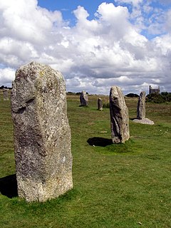
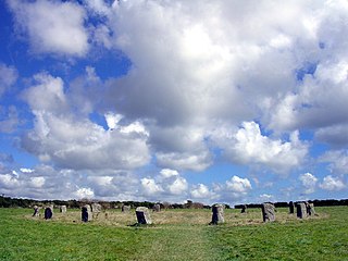
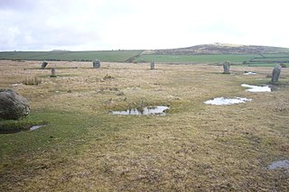
The Hurlers is a group of three stone circles in the civil parish of St Cleer, Cornwall, England, UK. The site is half-a-mile (0.8 km) west of the village of Minions on the eastern flank of Bodmin Moor, and approximately four miles (6 km) north of Liskeard at grid reference SX 258 714.
The Merry Maidens, also known as Dawn's Men is a late neolithic stone circle located 2 miles (3 km) to the south of the village of St Buryan, in Cornwall, United Kingdom. A pair of standing stones, The Pipers is associated both geographically and in legend.

Doll Tor is a stone circle located just to the west of Stanton Moor, near the village of Birchover, Derbyshire in the English East Midlands. Doll Tor is part of a tradition of stone circle construction that spread throughout much of Britain, Ireland, and Brittany during the Late Neolithic and Early Bronze Ages, over a period between 3300 and 900 BCE. The purpose of such monuments is unknown, although archaeologists speculate that the stones represented supernatural entities for the circles' builders.

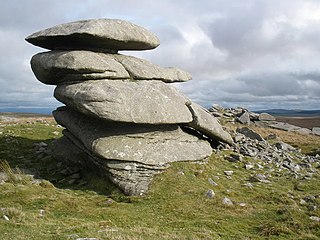
Rough Tor, or Roughtor, is a tor on Bodmin Moor, Cornwall, United Kingdom. The site is composed of the tor summit and logan stone, a neolithic tor enclosure, a large number of Bronze Age hut circles, and some contemporary monuments.

Christian Arthur Edgar "Tim" O'Brien was a British exploration geologist and author. In 1936 he was also involved in the discovery of the Chogha Zanbil Ziggurat in Southern Iran. Appointed by BP In 1967, he retired in 1971 as Chairman of the Boards and General managing director of the Iranian Oil Operating Companies, stationed in Tehran, and was awarded a CBE for services to the Oil Industry.

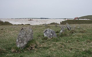
Craddock Moor Stone Circle or Craddock Moor Circle is a stone circle located near Minions on Bodmin Moor in Cornwall, UK. It is situated around half a mile Northwest of The Hurlers.
Stannon stone circle is a stone circle located near St. Breward on Bodmin Moor in Cornwall, England.

Fernacre, also known as Fernacre stone circle or Fernacre circle, is a stone circle located on the slopes of the De Lank River, 1.25 miles (2.01 km) northeast of St Breward on Bodmin Moor in Cornwall in the United Kingdom.
Showery Tor is a rocky outcrop on a ridge-top approximately 0.6 kilometres (0.37 mi) north of the Rough Tor summit, near Camelford on Bodmin Moor in Cornwall. It is notable for its rock formations and prehistoric monuments.

Goodaver, Goodaver stone circle or Goodaver circle is a stone circle located in the parish of Altarnun, near Bolventor on Bodmin Moor in Cornwall, UK.
The Trippet stones or Trippet stones circle is a stone circle located on Manor Common in Blisland, 9 kilometres (5.6 mi) north northeast of Bodmin on Bodmin Moor in Cornwall, UK. The Stripple stones are nearby.

The Nine Stones is a stone circle 3 kilometres (1.9 mi) south southeast of Altarnun, 11 kilometres (6.8 mi) west of Launceston on Bodmin Moor in Cornwall, UK.

Helman Tor is a tor in mid Cornwall, England, UK. It is a nature reserve managed by the Cornwall Wildlife Trust. It is a County Geology Site and a Scheduled Ancient Monument. It lies on the Saints' Way. It is adjacent to Red Moor Site of Special Scientific Interest and Breney Common Special Area of Conservation.

Brown Willy is a hill in Cornwall, England, United Kingdom. The summit, at 1,378 feet above sea level, is the highest point of Bodmin Moor and of Cornwall as a whole. It is about 2+1⁄2 miles northwest of Bolventor and 4 miles southeast of Camelford. The hill has a variable appearance that depends on the vantage point from which it is seen. It bears the conical appearance of a sugarloaf from the north but widens into a long multi-peaked crest from closer range.
A ring cairn is a circular or slightly oval, ring-shaped, low embankment, several metres wide and from 8 to 20 metres in diameter. It is made of stone and earth and was originally empty in the centre. In several cases the middle of the ring was later used. The low profile of these cairns is not always possible to make out without conducting excavations.
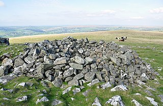
A tor cairn is a prehistoric cult site occurring in the British Isles, especially in Cornwall and Devon but also in Wales. It consists of a circular enclosure of stones or a platform of loose rocks surrounding a natural tor, sometimes encircled by a ditch. The diameter of the roughly 35 tor cairns ranges from 12 to over 30 metres and their height varies from 0.5 to 4.0 metres. There is usually an entrance to the enclosed area and pits in the ground between the rock outcrop (tor) itself and the enclosure.

Stowe's Hill is an elongated hill, 381 metres (1,250 ft) high, located on the eastern edge of Bodmin Moor in the county of Cornwall, England.
Leskernick Hill is on Bodmin Moor in Cornwall, UK. It is 329m high and has grid reference SX183803.. Leskernick Hill is within the Cornwall AONB as part of Area 12: Bodmin Moor in the parish of Altarnun. It lies in an area of moorland that is common land. Its parent hill is Brown Willy and it is within sight of Rough Tor and other local tors


