
Walsall is a market town and administrative centre of the borough of the same name in the West Midlands, England. Historically part of Staffordshire, it is located 9 miles (14 km) northwest of Birmingham, 7 miles (11 km) east of Wolverhampton and 9 miles (14 km) southwest of Lichfield.
The Metropolitan Borough of Walsall is a metropolitan borough in the West Midlands, England. It is named after its largest settlement, Walsall, but covers a larger area which also includes Aldridge, Bloxwich, Brownhills, Darlaston, Pelsall and Willenhall.

Bloxwich is a market town and civil parish in the Metropolitan Borough of Walsall, West Midlands, England. It is located between the towns of Walsall, Cannock, Willenhall and Brownhills.

Leamore is a suburb of Bloxwich and Walsall in Metropolitan Borough of Walsall, West Midlands county, England. It is a mix of private and council housing built since the late 19th century. The most significant homes in the area are several multi-storey blocks of council flats, which were built in the 1960s.

Blakenall Heath is a suburban village in the Metropolitan Borough of Walsall in the West Midlands County, England. It straddles the border of Walsall and Bloxwich. Historically the village was a part of Staffordshire. It was originally a rural area between Walsall and Bloxwich with a small amount of private housing as recently as the beginning of the 20th century, but the area began to change dramatically after the end of the Great War.

Walsall North was a constituency in the West Midlands represented in the House of Commons of the UK Parliament, created in 1955.

Walsall South was a constituency in the West Midlands in the House of Commons of the UK Parliament. It was represented since 1974 until abolition by members of the Labour Party.
New Invention is a large estate around three miles (4.8 km) north of the town of Willenhall and four miles (6.4 km) east of the city of Wolverhampton in the Metropolitan Borough of Walsall, West Midlands, England. It is halfway between Walsall and Wolverhampton on the busy main A4124 and A462 roads.

Pelsall is a village in the Metropolitan Borough of Walsall, West Midlands, England. Forming part of the borough's border with Staffordshire, Pelsall is located 4 miles north of Walsall, midway between the towns of Bloxwich and Brownhills and 4 miles northwest of Aldridge. The southern edge of Cannock Chase is 6 miles to the north. Pelsall is also 8 miles southwest of Lichfield and 8 miles northeast of Wolverhampton.

Landywood is a village in the South Staffordshire district of Staffordshire, England. Landywood is part of the South Staffordshire ward named "Great Wyrley Landywood", It lies 3 miles (4.8 km) north of Bloxwich, 3 miles (4.8 km) south from Cannock and 6 miles (9.7 km) north of Walsall.
Walsall Metropolitan Borough Council elections are held three years out of every four, with a third of the council elected each time. Walsall Metropolitan Borough Council, which styles itself "Walsall Council", is the local authority for the metropolitan district of Walsall in the West Midlands, England. Since the last boundary changes in 2004, 60 councillors have been elected from 20 wards.

Bloxwich railway station serves Bloxwich, in the Metropolitan Borough of Walsall, West Midlands, England. The station, and all trains serving it, are operated by West Midlands Railway.

Bloxwich North railway station serves the town of Bloxwich in the Metropolitan Borough of Walsall, West Midlands, England. The station, and all trains serving it, are operated by West Midlands Railway.

Lower Farm Estate is a suburb of Bloxwich, in the Metropolitan Borough of Walsall, West Midlands, England.
Pheasey is a residential area of Walsall Metropolitan Borough in the West Midlands of England, often considered to be part of Great Barr. The area was predominantly developed for housing, as the Pheasey Estate, in the 1930s, but work was not completed until after the Second World War. Barr Beacon, a hill, is a local landmark.
The Lodge Farm estate is located in the area of Short Heath in the town of Willenhall, which is in the Metropolitan Borough of Walsall.

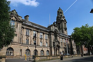
Walsall Council, formally Walsall Metropolitan Borough Council, is the local authority for the Metropolitan Borough of Walsall in the West Midlands, England. The town of Walsall had been a borough from medieval times, which was reformed on numerous occasions. Since 1974 the council has been a metropolitan borough council. It provides the majority of local government services in the borough. The council has been a member of the West Midlands Combined Authority since 2016.

Wallington Heath is an area of Bloxwich in the Metropolitan Borough of Walsall in the West Midlands county of England. It was described in 1856 as a hamlet in the township of Bloxwich. The area of Wallington Heath was amongst the land enclosed by Bloxwich Town Council in 1888 for recreational use, under an agreement drawn up with Lord Bradford and his trustees. It lies north of Bloxwich town centre on the A34 road to Cannock and is bounded by Little Bloxwich, Lower Farm Estate, Mossley and Turnberry Estate.

