
The South Santiam River is a tributary of the Santiam River, about 69 miles (111 km) long, in western Oregon in the United States. It drains an area of the Cascade Range into the Willamette Valley east of Corvallis.

The Clatskanie River is a tributary of the Columbia River, approximately 25 miles (40 km) long, in northwestern Oregon in the United States. It drains a timber-producing area in the foothills of the Northern Oregon Coast Range north-northwest of Portland.
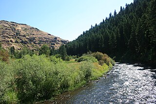
The Minam River is a tributary of the Wallowa River, 51 miles (82 km) long, in northeastern Oregon in the United States. It drains a rugged wilderness area of the Wallowa Mountains northeast of La Grande.
The South Fork Rogue River is a 25-mile (40 km) tributary of the Rogue River in the U.S. state of Oregon. Rising in the Sky Lakes Wilderness in the Cascade Range, it flows generally northeast through the Rogue River – Siskiyou National Forest to meet the Rogue River downstream of Prospect and slightly upstream of Lost Creek Lake.
West Little Owyhee River is a 63.1-mile-long (101.5 km) tributary of the Owyhee River in the U.S. state of Oregon. The source of the river is at an elevation of 6,508 feet (1,984 m) near McDermitt, while the mouth is at an elevation of 4,373 feet (1,333 m) in the Owyhee Desert. West Little Owyhee River has a 310-square-mile (800 km2) watershed.
The Winchuck River is a short coastal stream that runs through the Rogue River–Siskiyou National Forest to the Pacific Ocean in the U.S. states of Oregon and California. Flowing generally west from its origin near Elk Mountain, the river enters the sea at Crissey Field State Recreation Site, about 1⁄2 mile (0.80 km) north of the Oregon–California border and about 5 miles (8 km) south of Brookings.

French Pete Creek is a tributary of the South Fork McKenzie River in Lane County, in the U.S. state of Oregon. It flows generally west through the Three Sisters Wilderness to the south end of Cougar Reservoir, about 11 miles (18 km) from the larger river's confluence with the McKenzie River. The creek has two named tributaries—Olallie Creek and, further downstream, Pat Creek—both of which enter from the right.
Roaring River is a tributary of the South Fork McKenzie River in Lane County in the U.S. state of Oregon. It begins along the west side of Roaring River Ridge in the Cascade Range and flows generally north through the Willamette National Forest to meet the larger stream about 22 miles (35 km) from its confluence with the McKenzie River.
Beaver Creek is a tributary of the Crooked River in the U.S. state of Oregon. It is formed by the confluence of its two forks in southeastern Crook County, a sparsely populated part of Central Oregon. North Fork Beaver Creek flows south and then west around Laughlin Table. South Fork Beaver Creek drains the slopes of Snow Mountain and Funny Butte in southwestern Grant County before joining the North Fork.
The South Fork Burnt River is a tributary of the Burnt River in Baker County in the U.S. state of Oregon. Its headwaters lie in the Monument Rock Wilderness and the Wallowa–Whitman National Forest of the Blue Mountains. It flows generally northeast for about to meet the main stem at Unity Reservoir, north of Unity. The river, about 12 miles (19 km) long, crosses under U.S. Route 26 about 3 miles (5 km) northwest of Unity.

The North Fork Umatilla River is a tributary of the Umatilla River in Union and Umatilla counties in the U.S. state of Oregon. Its headwaters lie in the Umatilla National Forest in the Blue Mountains of northeastern Oregon. It flows generally northwest to meet the South Fork Umatilla River near Graves Butte. Together the two forks form the main stem Umatilla.
The South Fork Umatilla River is a tributary of the Umatilla River in Umatilla County in the U.S. state of Oregon. Its headwaters lie in the Umatilla National Forest in the Blue Mountains of northeastern Oregon near Pileup Saddle and Black Mountain. The South Fork flows generally north between Goodman Ridge and Bobsled Ridge to meet the North Fork Umatilla River near Graves Butte. Together the forks form the main stem Umatilla.
The Little Minam River is a tributary of the Minam River in Union County in the U.S. state of Oregon. It begins at the base of Cartwheel Ridge in the Wallowa Mountains and flows generally north through the Wallowa–Whitman National Forest to meet the main stem river at the north end of Backbone Ridge.
The Little Willamette River is a minor tributary of the Willamette River in Linn County in the U.S. state of Oregon. It begins in a gravel pit slightly east of the main stem in a bend of the larger river west of Albany. Flowing generally northeast and roughly parallel to the main stem for about 3 miles (5 km), it enters the Willamette about 121.5 miles (195.5 km) from the larger river's mouth on the Columbia River.
The North Fork Smith River is a 34-mile (55 km) tributary of the Smith River in Douglas County in the U.S. state of Oregon. It begins in the Central Oregon Coast Range near Roman Nose Mountain and flows generally southwest to meet the larger river 16 miles (26 km) from its confluence with the Umpqua River at Reedsport. The entire course of the North Fork lies within the Siuslaw National Forest.

The North Fork Smith River is 28-mile (45 km) tributary of the Smith River that begins in the U.S. state of Oregon and ends in the U.S. state of California. Arising near Chetco Peak in the Klamath Mountains, it flows generally south to meet the Middle Fork Smith River at Gasquet, California. The combined streams form the Smith River.
Eagle Creek is a tributary, 41 miles (66 km) long, of the Powder River in the northeastern part of the U.S. state of Oregon. Beginning at Eagle Lake in the Wallowa Mountains, the creek flows generally southwest and then southeast to meet the river near the small city of Richland. The creek's headwaters are in the Eagle Cap Wilderness within the Wallowa–Whitman National Forest. The upper 28.9 miles (46.5 km) of the creek, from Eagle Lake to the national forest boundary at Skull Creek, are part of the National Wild and Scenic Rivers System.

Cavitt Creek is a tributary of the Little River in Douglas County in the U.S. state of Oregon. From its source near Red Butte, the creek flows generally west then north through the Umpqua National Forest of the Cascade Range before entering the river about 1.5 miles (2.4 km) upstream of the rural community of Peel and 7 miles (11 km) above the Little River's mouth on the North Umpqua River.
