Little Indian, Illinois | |
|---|---|
 Little Indian, Illinois  Little Indian, Illinois | |
| Coordinates: 39°53′15″N90°12′04″W / 39.88750°N 90.20111°W | |
| Country | United States |
| State | Illinois |
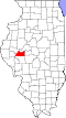
| County | Cass |
| Elevation | 600 ft (200 m) |
| Time zone | UTC-6 (Central (CST)) |
| • Summer (DST) | UTC-5 (CDT) |
| Area code | 217 |
| GNIS feature ID | 422917 [1] |
Little Indian is an unincorporated community in Cass County, Illinois, United States. Little Indian is located near Illinois Route 78, south of Virginia.