Little Luckiamute River

Last updated
Little Luckiamute River
Little Luckiamute River in 2010.jpg
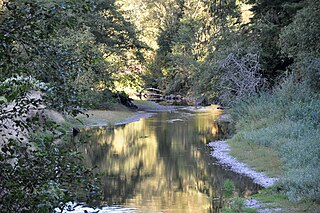
Rapids on the Little Luckiamute River
USA Oregon location map.svg
Red pog.svg
Location of the mouth of the Little Luckiamute River in Oregon
EtymologyNative American but of unknown meaning [1]
Location
Country United States
State Oregon
County Polk
Physical characteristics
Source Central Oregon Coast Range
 - locationnear Fanno Peak
 - coordinates 44°52′45″N123°37′37″W / 44.87917°N 123.62694°W / 44.87917; -123.62694 [2]
 - elevation2,869 ft (874 m) [3]
Mouth Luckiamute River
 - locationabout 4 miles (6 km) upstream of Sarah Helmick State Recreation Site
 - coordinates 44°47′28″N123°17′17″W / 44.79111°N 123.28806°W / 44.79111; -123.28806 Coordinates: 44°47′28″N123°17′17″W / 44.79111°N 123.28806°W / 44.79111; -123.28806 [2]
 - elevation203 ft (62 m) [2]
Length24 mi (39 km) [4]
Discharge 
 - locationHelmick State Recreation Site, 13.5 miles (21.7 km) from the mouth
Basin features
Basin size54 sq mi (140 km2) [5]

The Little Luckiamute River is a stream in Polk County in the U.S. state of Oregon. It rises in the Central Oregon Coast Range near Fanno Peak and joins the Luckiamute River about 4 miles (6 km) upstream of the Sarah Helmick State Recreation Site southwest of Monmouth. [4]

Polk County, Oregon County in the United States

Polk County is a county located in the U.S. state of Oregon. As of the 2010 census, the population was 75,403, making it the least populous county in the Willamette Valley. The county seat is Dallas. The county is named for James Knox Polk, the 11th president of the United States.

Oregon State of the United States of America

Oregon is a state in the Pacific Northwest region on the West Coast of the United States. The Columbia River delineates much of Oregon's northern boundary with Washington, while the Snake River delineates much of its eastern boundary with Idaho. The parallel 42° north delineates the southern boundary with California and Nevada. Oregon is one of only three states of the contiguous United States to have a coastline on the Pacific Ocean.

Central Oregon Coast Range

The Central Oregon Coast Range is the middle section of the Oregon Coast Range, in the Pacific Coast Ranges physiographic region, and located in the west-central portion of the state of Oregon, United States roughly between the Salmon River and the Umpqua River and the Willamette Valley and the Pacific Ocean. This approximately 90-mile (140 km) long mountain range contains mountains as high as 4,097 feet for Marys Peak. Portions of the range are inside the Siuslaw National Forest and three wilderness areas exist as well: Drift Creek Wilderness, Cummins Creek Wilderness and Rock Creek Wilderness.

Contents

Flowing generally east from its source near Fanno Peak, the river parallels Fanno Ridge, which is to the right. Lost Creek enters from the left at a rapids, and Camp Creek enters from the left 20.6 miles (33.2 km) from the mouth. About 0.5 miles (0.80 km) further on, the river passes over a waterfall. Approaching the unincorporated community of Black Rock, Little Luckiamute River receives Black Rock Creek from the left at river mile (RM) 17 or river kilometer (RK) 27. For several miles starting at Black Rock, the George T. Gerlinger Experimental Forest is on the river's left. Sam's Creek enters from the left about 1 mile (1.6 km) downstream of Black Rock. [4] [6]

Black Rock is an unincorporated community and former logging camp in Polk County, Oregon, United States. It is located about three miles west of Falls City, in the Central Oregon Coast Range on the Little Luckiamute River.

River mile

In the United States, a river mile is a measure of distance in miles along a river from its mouth. River mile numbers begin at zero and increase further upstream. The corresponding metric unit using kilometers is the river kilometer. They are analogous to vehicle roadway mile markers, except that river miles are rarely marked on the physical river; instead they are marked on navigation charts, and topographic maps. Riverfront properties are sometimes partially legally described by their river mile.

George T. Gerlinger was influential in the railroad and lumber products business in the U.S. state of Oregon in the early 20th century. The oldest son of Louis Gerlinger, Sr., in 1902 he organized a group of investors in Dallas, Oregon to build railroad lines in the area.

Gerlinger County Park is on the right at RM 15 (RK 24). Dutch Creek enters from the left and Berry Creek from the right before the river reaches Falls City Falls and Falls City about 13 miles (21 km) from the mouth. [4] [6] At the falls, the river plunges 25 to 35 feet (7.6 to 10.7 m) into a gorge within a city park. [7] Turning southeast, the river receives Waymire Creek from the left, then Teal Creek from the right, then passes under Oregon Route 223 at about RM 8 (RK 13). Fern Creek enters from the left just beyond Route 223, and Cooper Creek enters from the left about 1.5 miles (2.4 km) from the mouth. The Little Luckiamute River meets the Luckiamute River about 18 miles (29 km) from the larger river's confluence with the Willamette River. [4] [6]

Falls City, Oregon City in Oregon, United States

Falls City is a city in Polk County, Oregon, United States. The population was 947 at the 2010 census. It is part of the Salem Metropolitan Statistical Area.

Oregon Route 223 highway in Oregon

Oregon Route 223 is a state highway in the U.S. State of Oregon, which runs between the town of Wren, Oregon and the city of Dallas, Oregon. It is known as the Kings Valley Highway No. 191 and is 31 miles (50 km) long. It lies in Benton and Polk counties.

Willamette River major river in northwest Oregon

The Willamette River is a major tributary of the Columbia River, accounting for 12 to 15 percent of the Columbia's flow. The Willamette's main stem is 187 miles (301 km) long, lying entirely in northwestern Oregon in the United States. Flowing northward between the Oregon Coast Range and the Cascade Range, the river and its tributaries form the Willamette Valley, a basin that contains two-thirds of Oregon's population, including the state capital, Salem, and the state's largest city, Portland, which surrounds the Willamette's mouth at the Columbia.

The upper river supports catch-and-release fishing for wild coastal cutthroat trout ranging in size from 6 to 13 inches (15 to 33 cm). [8]

Coastal cutthroat trout subspecies of fish

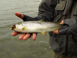
The coastal cutthroat trout also known as the sea-run cutthroat trout, or harvest trout is one of the several subspecies of cutthroat trout found in Western North America. The coastal cutthroat trout occurs in four distinct forms. A semi-anadromous or sea-run form is the most well known. Freshwater forms occur in both large and small rivers and streams and lake environments. The native range of the coastal cutthroat trout extends south from the southern coastline of the Kenai Peninsula in Alaska to the Eel River in Northern California. Coastal cutthroat trout are resident in tributary streams and rivers of the Pacific basin and are rarely found more than 100 miles (160 km) from the ocean.

See also

Related Research Articles

Tualatin River river in the United States of America

The Tualatin River is a tributary of the Willamette River in Oregon in the United States. The river is about 83 miles (134 km) long, and it drains a fertile farming region called the Tualatin Valley southwest and west of Portland at the northwest corner of the Willamette Valley. There are approximately 500,000 people residing on 15 percent of the land in the river's watershed.

Yamhill River river in the United States of America

The Yamhill River is an 11-mile (18 km) tributary of the Willamette River, in the U.S. state of Oregon. Formed by the confluence of the South Yamhill River and the North Yamhill River about 3 miles (5 km) east of McMinnville, it drains part of the Northern Oregon Coast Range. The river meanders east past Dayton to join the Willamette River at its river mile (RM) 55 or river kilometer (RK) 89, south of Newberg.

Siletz River river in the United States of America

The Siletz River flows about 67 miles (108 km) to the Pacific Ocean through coastal mountains in the U.S. state of Oregon. Formed by the confluence of its north and south forks near Valsetz in Polk County, it winds through the Central Oregon Coast Range. The river, draining a watershed of 373 square miles (970 km2), empties into Siletz Bay, south of Lincoln City in Lincoln County. Although the river travels 67 miles (108 km) in river miles, its winding course begins only about 20 miles (32 km) east of the ocean, and its mouth and source latitudes are almost identical.

North Yamhill River river in the United States of America

The North Yamhill River is a 31-mile (50 km) tributary of the Yamhill River in the U.S. state of Oregon. It drains an area of the Northern Oregon Coast Range, as well as part of the Willamette Valley west of the Willamette River.

South Yamhill River tributary of the Yamhill River in northwest Oregon

The South Yamhill River is a tributary of the Yamhill River, approximately 60 miles (97 km) long, in northwest Oregon in the United States. It drains an area of the Northern Oregon Coast Range, as well as part of the Willamette Valley west of the Willamette River.

Luckiamute River watercourse in the United States of America

The Luckiamute River is a tributary of the Willamette River, about 61 miles (98 km) long, in western Oregon in the United States. It drains an area of Central Oregon Coast Range and the western Willamette Valley northwest of Corvallis.

Big River (Oregon) river in Oregon, United States of America

The Big River is a tributary of the Coast Fork Willamette River, approximately 12 miles (19 km) long, in western Oregon in the United States. It drains an area of the Calapooya Mountains south of Eugene.

Miami River (Oregon) river in United States of America

The Miami River is a stream, approximately 13 miles (21 km) long, on the coast of northwest Oregon in the United States. It drains a mountainous timbered region of the Northern Oregon Coast Range west of Portland, into Pacific Ocean.

Collawash River river in the United States of America

The Collawash River is a 12-mile (19 km) tributary of the Clackamas River in the U.S. state of Oregon. Formed by the confluence of Elk Lake Creek and the East Fork Collawash River in the Cascade Range, it flows generally north-northwest from source to mouth through the Mount Hood National Forest. The largest tributary of the upper Clackamas, it provides about a third of bigger river's low-flow volume. About 35 percent of its watershed of 150 square miles (390 km2) is protected as wilderness.

Abiqua Creek river in Oregon, United States of America

Abiqua Creek is a tributary of the Pudding River in the U.S. state of Oregon. The creek originates near Lookout Mountain in the foothills of the Cascade Range in the northwestern part of the state. It flows northwest for about 29 miles (47 km) to its confluence with the Pudding, about 2 miles (3.2 km) west of Silverton, in the Willamette Valley. About 20 miles (32 km) north of Silverton, the Pudding River meets the Molalla River, which meets the Willamette River less than 1 mile (1.6 km) later near Canby.

Imnaha River tributary of the Snake River in Oregon

The Imnaha River is a 73.3-mile-long (118.0 km) tributary of the Snake River in the U.S. state of Oregon. Flowing generally east near the headwaters and then north through Wallowa County, the entire river is designated Wild and Scenic. It follows a geologic fault to the Snake River, and in addition to land in the Wallowa–Whitman National Forest and private land, its corridor includes parts of three special management areas: the Eagle Cap Wilderness, Hells Canyon National Recreation Area, and Hells Canyon Scenic Byway. The Imnaha flows by the unincorporated community of Imnaha, the only settlement along its course, and enters the Snake River roughly 4 miles (6 km) from the larger river's confluence with the Salmon River of Idaho and 192 miles (309 km) from its confluence with the Columbia River.

Umatilla River tributary of the Columbia River in Oregon

The Umatilla River is an 89-mile (143 km) tributary of the Columbia River in the U.S. state of Oregon. Draining a basin of 2,450 square miles (6,300 km2), it enters the Columbia near the city of Umatilla in the northeastern part of the state. In downstream order, beginning at the headwaters, major tributaries of the Umatilla River are the North Fork Umatilla River and the South Fork Umatilla River, then Meacham, McKay, Birch, and Butter creeks.

Row River river in the United States of America

The Row River is a river, approximately 20 miles (32 km) long, in Lane County, Oregon, United States. It rises in the Cascade Range and flows into the Coast Fork Willamette River near Cottage Grove. The stream was originally known as the "East Fork Coast Fork", but was later renamed after a dispute (row) between neighbors and brothers-in-law George Clark and Joseph Southwell over "trespassing" livestock. Clark was killed as a result of the row. The name rhymes with "cow" rather than with "slow". A post office named Row River operated from 1911 to 1914 a little north of the present site of Dorena at 43.740123°N 122.880347°W.

Gales Creek (Oregon) river in the United States of America

Gales Creek, is a tributary, 23.5 miles (37.8 km) long, of the Tualatin River in Washington County, Oregon, United States. The headwaters of Gales Creek are on the north side of the mountain Round Top in the Northern Oregon Coast Range. The community of Gales Creek, Oregon, is near the creek, which further downstream forms the southwest border of the city of Forest Grove.

Course of the Rogue River (Oregon) river in the United States of America

The Rogue River in the U.S. state of Oregon begins at Boundary Springs on the border between Klamath and Douglas counties near the northern edge of Crater Lake National Park. The Rogue River flows generally west for 215 miles (346 km) from the Cascade Range through the Rogue River – Siskiyou National Forest and the Klamath Mountains to the Pacific Ocean at Gold Beach. Communities along its course include Union Creek, Prospect, Trail, Shady Cove, Gold Hill, and Rogue River, all in Jackson County; Grants Pass, and Galice in Josephine County, and Agness, Wedderburn and Gold Beach in Curry County. Significant tributaries include the South Fork Rogue River, Elk Creek, Bear Creek, the Applegate River, and the Illinois River. Arising at 5,320 feet (1,622 m) above sea level, the river loses more than 1 mile (1.6 km) in elevation by the time it reaches the Pacific.

South Fork Rogue River tributary of the Rogue River in Oregon

The South Fork Rogue River is a 25-mile (40 km) tributary of the Rogue River in the U.S. state of Oregon. Rising in the Sky Lakes Wilderness in the Cascade Range, it flows generally northeast through the Rogue River – Siskiyou National Forest to meet the Rogue River downstream of Prospect and slightly upstream of Lost Creek Lake.

Course of the Willamette River

The Willamette River is a 187-mile (301 km) tributary of the Columbia River in the U.S. state of Oregon. The upper tributaries of the Willamette originate in mountains south and southeast of Eugene and Springfield. Formed by the confluence of the Middle Fork Willamette River and Coast Fork Willamette River near Springfield, the main stem meanders generally north from source to mouth. The river's two most significant course deviations occur at Newberg, where the stream turns sharply east, and about 18 miles (29 km) downriver from Newberg, where it turns north again. Near its mouth, the river splits into two channels that flow around Sauvie Island. The main channel enters the Columbia about 101 miles (163 km) from the larger stream's mouth on the Pacific Ocean, and the smaller Multnomah Channel enters the Columbia about 14.5 miles (23.3 km) further downstream near St. Helens in Columbia County.

West Fork Millicoma River river in the United States of America

The West Fork Millicoma River is a tributary, about 34 miles (55 km) long, of the Millicoma River in the U.S. state of Oregon. Rising in northeastern Coos County near the Douglas County line, it flows generally southwest through the Elliott State Forest of the Southern Oregon Coast Range to the community of Allegany. There it joins the East Fork Millicoma River to form the Millicoma. In turn, the Millicoma, which is only about 9 miles (14 km) long, joins the South Fork Coos River to form the Coos River. The Coos River, itself only about 5 miles (8 km) long, empties into the eastern end of Coos Bay, which connects to the Pacific Ocean.

South Fork Coos River river in the United States of America

The South Fork Coos River is a tributary, about 32 miles (51 km) long, of the Coos River in the U.S. state of Oregon. Formed by the confluence of the Williams River and Tioga Creek, it begins in eastern Coos County near the Douglas County line and flows generally northwest through the Southern Oregon Coast Range. East of the city of Coos Bay, it joins the Millicoma River to form the Coos River. This larger river, only about 5 miles (8 km) long, empties into the eastern end of Coos Bay, which connects to the Pacific Ocean.

South Fork McKenzie River tributary of the McKenzie River in Oregon

The South Fork McKenzie River is a tributary, about 31 miles (50 km) long, of the McKenzie River in the U.S. state of Oregon. It begins at about 4,500 feet (1,400 m) above sea level near Mink Lake in the Three Sisters Wilderness of the Cascade Range. Flowing northwest within Lane County, it meets the McKenzie River about 60 miles (97 km) from the larger river's confluence with the Willamette River.

References

  1. McArthur, Lewis A.; McArthur, Lewis L. (2003) [1928]. Oregon Geographic Names, 7th ed. Portland, Oregon: Oregon Historical Society Press. pp. 597&ndash, 98. ISBN   0-87595-277-1.
  2. 1 2 3 "Little Luckiamute River". Geographic Names Information System (GNIS). United States Geological Survey. November 28, 1980. Retrieved October 25, 2011.
  3. Source elevation derived from Google Earth search using GNIS source coordinates.
  4. 1 2 3 4 5 "United States Topographic Map". United States Geological Survey. Retrieved March 4, 2016 via Acme Mapper. The map quadrants include river-mile (RM) markers to RM 20.6 (river kilometer 33.2). The remaining distance is an estimate based on map scale and ruler.
  5. Marys Peak Resource Area support team (September 1998). "Rowell Creek, Mill Creek, Rickreall Creek, Luckiamute River Watershed Analysis" (PDF). Bureau of Land Management. p. R&CC-17. Retrieved October 24, 2011.
  6. 1 2 3 Oregon Atlas & Gazetteer. Freeport, Maine: DeLorme Mapping. 1991. pp. 52–53. ISBN   0-89933-235-8.
  7. Plumb, Gregory A. (2004). Waterfall Lover's Guide: Pacific Northwest (4th ed.). The Mountaineers Books. p. 195. ISBN   0-89886-911-0.
  8. Sheehan, Madelynne Diness. Fishing in Oregon (10th ed.). Scappoose, Oregon: Flying Pencil Publications. pp. 149–50. ISBN   0-916473-15-5.