Little Snake River

Last updated
Little Snake River [1]

Little Snake River.JPG

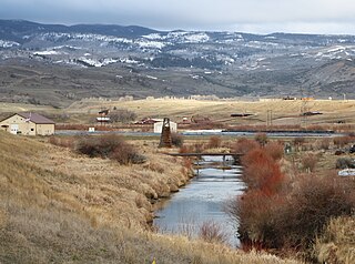
The river as it passes under Wyoming Highway 70 near Dixon.
Yampa river basin map.png
Physical characteristics
Main source Confluence of Middle Fork and North Fork
7,001 ft (2,134 m)
40°59′36″N107°02′51″W / 40.99333°N 107.04750°W / 40.99333; -107.04750
River mouth Confluence with Yampa River
5,620 ft (1,710 m)
40°27′09″N108°26′32″W / 40.45250°N 108.44222°W / 40.45250; -108.44222 Coordinates: 40°27′09″N108°26′32″W / 40.45250°N 108.44222°W / 40.45250; -108.44222
Basin features
Progression YampaGreenColorado
The Little Snake River, a tributary of the Yampa River, is shown highlighted on a map of the western United States Wpdms nasa topo little snake river.jpg
The Little Snake River, a tributary of the Yampa River, is shown highlighted on a map of the western United States

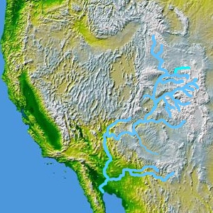
The Little Snake River is a tributary of the Yampa River, approximately 155 miles (249 km) long, in southwestern Wyoming and northwestern Colorado in the United States.

Yampa River river in northwestern Colorado, United States

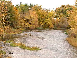
The Yampa River flows 250 miles (400 km) through northwestern Colorado in the United States. Rising in the Rocky Mountains, it is a tributary of the Green River and a major part of the Colorado River system. The Yampa is one of the few free-flowing rivers in the western United States, with only a few small dams and diversions.

Wyoming State of the United States of America

Wyoming is a state in the mountain region of the western United States. The state is the 10th largest by area, the least populous, and the second most sparsely populated state in the country. Wyoming is bordered on the north by Montana, on the east by South Dakota and Nebraska, on the south by Colorado, on the southwest by Utah, and on the west by Idaho and Montana. The state population was estimated at 577,737 in 2018, which is less than 31 of the most populous U.S. cities including Denver in neighboring Colorado. Cheyenne is the state capital and the most populous city, with an estimated population of 63,624 in 2017.

Colorado State of the United States of America

Colorado is a state of the Western United States encompassing most of the southern Rocky Mountains as well as the northeastern portion of the Colorado Plateau and the western edge of the Great Plains. It is the 8th most extensive and 21st most populous U.S. state. The estimated population of Colorado was 5,695,564 on July 1, 2018, an increase of 13.25% since the 2010 United States Census.

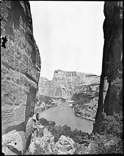
It rises near the continental divide, in Routt National Forest in northern Routt County, Colorado, along the northern edge of the Park Range. It flows west along the Wyoming-Colorado state line, meandering across the border several times and flowing past the Wyoming towns of Dixon and Baggs. It turns southwest and flows through Moffat County, Colorado, joining the Yampa approximately 45 mi (72 km) west of Craig, just east of Dinosaur National Monument. The Little Snake is not generally navigable except seasonally in years of plentiful water.

A continental divide is a drainage divide on a continent such that the drainage basin on one side of the divide feeds into one ocean or sea, and the basin on the other side either feeds into a different ocean or sea, or else is endorheic, not connected to the open sea. Every continent on earth except Antarctica which has no free-flowing water has at least one continental drainage divide; islands, even small ones like Killiniq Island on the Labrador Sea in Canada, may also host part of a continental divide or have their own island-spanning divide.

Routt County, Colorado County in the United States

Routt County is one of the 64 counties in the U.S. state of Colorado. As of the 2010 census, the population was 23,509. The county seat is Steamboat Springs.

Park Range (Colorado)

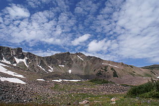
The Park Range, elevation approximately 12,000 feet (3,700 m), is a mountain range in the Rocky Mountains of northwestern Colorado in the United States. The range forms a relatively isolated part of the Continental Divide, extending north-to-south for approximately 40 miles (64 km) along the boundary between Jackson (east) and Routt counties. It separates North Park in the upper basin of the North Platte River on the east from the Elk River basin in the watershed of the Yampa River the west. It rises steeply out of the Yampa River basin, forming a climatic barrier that receives much snowfall in winter. The northern end of the range lies in Wyoming and is known as the Sierra Madre Range.

See also

Related Research Articles

Moffat County, Colorado County in the United States

Moffat County is the northwesternmost of the 64 counties in the U.S. state of Colorado. As of the 2010 census, the population was 13,795. The county seat is Craig.

North Platte River major tributary of the Platte River

The North Platte River is a major tributary of the Platte River and is approximately 716 miles (1,152 km) long, counting its many curves. In a straight line, it travels about 550 miles (890 km), along its course through the U.S. states of Colorado, Wyoming, and Nebraska.

Muddy Creek (Colorado) river in the United States of America

Muddy Creek is a tributary of the Colorado River, approximately 60.5 miles (97.4 km) long, in north central Colorado in the United States.

Laramie River river in the United States of America

The Laramie River is a tributary of the North Platte River, approximately 280 miles (450 km) long, in the U.S. states of Colorado and Wyoming. The river was named for Jacques La Ramie, a fur trapper who visited the area in the early 19th century. Laramie County, Wyoming, the city of Laramie, and other geographical entities in the region have "Laramie" in their names.

Weiser River river in the United States of America

The Weiser River is a 103-mile-long (166 km) tributary of the Snake River in western Idaho in the United States. It drains a mountainous area of 1,660 square miles (4,300 km2) consisting primarily of low rolling foothills intersected by small streams south and east of Hells Canyon along the Idaho-Oregon border.

Snake River (Colorado) river in Colorado, United States of America

The Snake River is a short tributary of the Blue River, approximately 15 miles (24 km) long, in central Colorado in the United States. It drains a mountainous area on the west side of the Front Range in southeastern Summit County east of Keystone.

Medicine Bow – Routt National Forest U.S. Forest Service managed area

Medicine Bow – Routt National Forest is the official title to a U.S. Forest Service managed area extending over 2,222,313 acres (8,993.38 km2) in the states of Wyoming and Colorado, United States. What were once three separate areas, Medicine Bow National Forest, Routt National Forest and Thunder Basin National Grassland were administratively combined in 1995 due to similarity of the resources, proximity to each other and for administrative purposes.

Yampa River State Park Park in Colorado, US

Yampa River State Park is a Colorado state park located along the Yampa River in Routt and Moffat Counties in northwestern Colorado in the United States.

Hoback River river in the United States of America

The Hoback River, once called the Fall River, is an approximately 55-mile (89 km)-long tributary of the Snake River in the U.S. state of Wyoming. It heads in the northern Wyoming Range of Wyoming and flows north and then east through the Bridger-Teton National Forest. Its largest tributary is its South Fork, which joins the Hoback about nine miles downstream of its head as it turns northeast and continues to U.S. Route 191. It then turns northwest, where it spreads onto a large marshy flat in a braided floodplain once known as Jackson's Little Hole, but now referred to as the "Hoback Basin" in which lies the town of Bondurant. It then enters the steep, narrow Hoback Canyon from which it emerges to join the Snake about 11 miles (18 km) south of Jackson Hole, just upstream of head of the Snake River Canyon near the town of Hoback. The entire length of the Hoback is free flowing and unobstructed by dams. About 30 miles (48 km) downstream from the confluence with the Hoback River, the Snake River crosses into the state of Idaho and is impounded by Palisades Dam.

Elk River (Colorado) stream in Colorado

Elk River is a 34.2-mile-long (55.0 km) stream in Colorado. It flows from a confluence of the North Fork Elk River and Middle Fork Elk River in Routt National Forest north of Steamboat Springs to a confluence with the Yampa River.

Bear River (Colorado) tributary of the Yampa River, sourced in Colorado

The Bear River is a 22.7-mile-long (36.5 km) tributary of the Yampa River. Its source is in the Flat Tops Wilderness above Stillwater Reservoir in Garfield County, Colorado. The Bear River flows northeast into Routt County and joins the Yampa River just east of the town of Yampa.

North Fork Little Snake River is a 13.1-mile-long (21.1 km) tributary of the Little Snake River in Colorado and Wyoming. It flows from a source in the Medicine Bow National Forest of Carbon County, Wyoming to a confluence with the Middle Fork Little Snake River in Routt County, Colorado that forms the Little Snake River.

Middle Fork Little Snake River is a 17.5-mile-long (28.2 km) tributary of the Little Snake River in Routt County, Colorado. It flows from a source near the Continental Divide in Routt National Forest to a confluence with the North Fork Little Snake River that forms the Little Snake River.

South Fork Little Snake River is an 18.2-mile-long (29.3 km) tributary of the Little Snake River in Routt County, Colorado. It flows north from a source in Routt National Forest near Steamboat Lake State Park to a confluence with the Little Snake River.

Roaring Fork Little Snake River is a 12.0-mile-long (19.3 km) tributary of the Little Snake River in Colorado and Wyoming. It flows from a source in the Medicine Bow National Forest of Carbon County, Wyoming to a confluence with the Little Snake River in Routt County, Colorado.

Elk Mountain (Routt County, Colorado) mountain in Routt County, Colorado, United States of America

Elk Mountain is a summit in Routt County, Colorado. The mountain lies to the northwest of Steamboat Springs and is easily seen from the city, especially from along Lincoln Avenue, Steamboat's main street. The mountain is also easily seen from Mount Werner, the home of the Steamboat Ski Resort.

References

  1. "Little Snake River". Geographic Names Information System . United States Geological Survey . Retrieved 2011-01-27.