
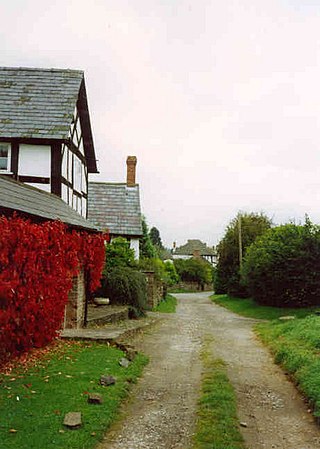
Bacton is a small village in a rural area of south-west Herefordshire, England, 14 miles from Hereford.

Welsh Newton is a small village and civil parish in the county of Herefordshire, England. It is located close to the border with Wales to which the parish extends towards Monmouthshire. It should not be confused with Newton, a township-chapelry in Clodock Parish and near Longtown, or with Newton Leominister. Its postal address is in Wales, with Monmouth as its post town.
The history of Herefordshire starts with a shire in the time of King Athelstan, and Herefordshire is mentioned in the Anglo-Saxon Chronicle in 1051. The first Anglo-Saxon settlers, the 7th-century Magonsætan, were a sub-tribal unit of the Hwicce who occupied the Severn valley. The Magonsætan were said to be in the intervening lands between the Rivers Wye and Severn. The undulating hills of marl clay were surrounded by the Welsh mountains to the west; by the Malvern Hills to the east; by the Clent Hills of the Shropshire borders to the north, and by the indeterminate extent of the Forest of Dean to the south. The shire name first recorded in the Anglo-Saxon Chronicle may derive from "Here-ford", Old English for "army crossing", the location for the city of Hereford.

Eardisley is a village and civil parish in Herefordshire about 5 miles (8.0 km) south of the centre of Kington. Eardisley is in the Wye valley in the northwest of the county, close to the border with Wales.

Archenfield is the historic English name for an area of southern and western Herefordshire in England. Since the Anglo-Saxons took over the region in the 8th century, it has stretched between the River Monnow and River Wye, but it derives from the once much larger Welsh kingdom of Ergyng.
Hope under Dinmore is a village and civil parish in Herefordshire, England. The village is on the A49 road, 4 miles (6 km) south of Leominster and 9 miles (14 km) north of Hereford, and on the Welsh Marches railway line. The railway passes under Dinmore Hill through the split-level 1,051-yard (961 m) long Dinmore Tunnel. Dinmore railway station closed in 1958, but the line remains open. The church has a tower and is dedicated to Saint Mary the Virgin.

Ganarew is a village and small civil parish in south Herefordshire, England near the River Wye and the border with Wales. The village is located 0.62 miles (1.00 km) southwest of the village of Whitchurch on the main A40 road, and lies within the electoral ward of Kerne Bridge. The village is about 2 miles (3.2 km) from Monmouth and 8 miles (13 km) from Ross-on-Wye. It contains the Church of St Swithin and Ganarew Manor.
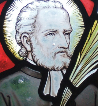
John Kemble was an English Roman Catholic martyr. He was one of the Forty Martyrs of England and Wales.

Ergyng was a Welsh kingdom of the sub-Roman and early medieval period, between the 5th and 7th centuries. It was later referred to by the English as Archenfield.
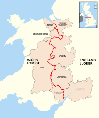
The England–Wales border, sometimes referred to as the Wales–England border or the Anglo-Welsh border, runs for 160 miles (260 km) from the Dee estuary, in the north, to the Severn estuary in the south, separating England and Wales.

Walterstone is a village and civil parish in Herefordshire, England, near the Welsh border and the Brecon Beacons National Park, 14 miles (23 km) south-west of Hereford. The parish had a population of 97 in the 2001 UK Census and is grouped with Craswall, Llanveynoe and Longtown to form Longtown Group Parish Council for administrative purposes.

Llanveynoe is a village and civil parish in Herefordshire, England, near the Welsh border and the Brecon Beacons National Park, 14 miles (23 km) south west of Hereford. The parish had a population of 104 in the 2001 UK Census and shares the Longtown grouped parish council with Craswall, Longtown and Walterstone.

Brampton Abbotts is a village and civil parish in Herefordshire, England. It is located 2 km north of Ross-on-Wye and 16 km south east of Hereford. The village lies near the western terminus of M50 motorway.

Clodock Welsh: Clydog is a village in the west of Herefordshire, England. It lies on the River Monnow in the foothills of the Black Mountains, close to the border with Wales. The village is in the civil parish of Longtown.
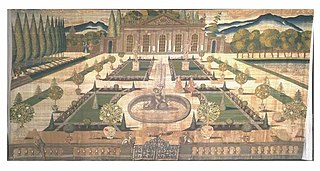
Stoke Edith House is a derelict country house with surrounding park in Stoke Edith, Herefordshire, England. The present 17th century quadrangular mansion was preceded by a multi-gabled, Elizabethan home. Set within gardens, it was destroyed by fire in 1927.

Cwm was a Jesuit gathering place, Ecclesiastical province and college in Llanrothal, Herefordshire, England. It became a Jesuit college in 1622. Based in a large farmhouse, the Cwm included two houses, called "Upper Cwm" and "Lower Cwm". They were divided by a walled forecourt and during their prime in the early 17th century each was able to generate £60 annually in rents from its own land.
Henry Milbourne, also Milburne or Milborne, was a Welsh magistrate who served as the Recorder of Monmouth and as agent to the Duke of Beaufort.

Hereford Cathedral Library is a working theological lending and reference library located in Hereford Cathedral, Hereford, England; it also holds books and manuscripts of major importance to the history of the county of Herefordshire. Hereford Cathedral Library is also well known for its chained books as it is the only library of this type to survive with all of the chains, rods and locks still intact.

Putley is a village and civil parish 8 miles (13 km) east of Hereford, in the county of Herefordshire, England. In 2011 the parish had a population of 245. The parish borders Aylton, Woolhope, Pixley, Much Marcle and Tarrington.

Llancillo is a civil parish in south-west Herefordshire, England, and is approximately 13 miles (20 km) south-west from Hereford. The parish borders Wales at the south in which is the nearest town, Abergavenny, 7 miles (11 km) to the south-southwest. In the parish is the isolated Grade II* listed 11th-century Church of St Peter.

