
The Snowdon Mountain Railway is a narrow gauge rack and pinion mountain railway in Gwynedd, north-west Wales. It is a tourist railway that travels for 4.7 miles (7.6 km) from Llanberis to the summit of Snowdon, the highest peak in Wales.

The Rhinogydd are a range of mountains located east of Harlech in North Wales. The name Rhinogydd derives from the names of two of the more famous peaks, Rhinog Fawr and Rhinog Fach, although the greatest elevation in the range is reached by Y Llethr, 756 m.

Crib Goch is an arête in the Snowdonia National Park in Gwynedd, Wales. The name means ‘red ridge’ in the Welsh language.
Welsh 3000s are the 15 mountains in Wales with a height over 3,000 feet (914.4 m). Geographically they fall within three ranges, but close enough to make it possible to reach all 15 summits within 24 hours, a challenge known as the Welsh 3000s challenge. All 15 are classed as Furths by the Scottish Mountaineering Club, meeting the criteria for a Scottish Munro, and are on the official list of SMC Furths.

Glyder Fawr is a mountain in Snowdonia, Wales, the highest peak in the Glyderau range at just over 1,000 metres, having had its height recalculated in 2010 using GPS. It is the fifth-highest mountain in Wales and has several walking and scrambling routes leading to its summit. According to Sir Ifor Williams, the word "Glyder" derives from the Welsh word "Gludair", meaning a heap of stones.

Moel Hebog is a mountain in Snowdonia, north Wales which dominates the view west from the village of Beddgelert. It gives name to a whole range of peaks in the north-western corner of Snowdonia, which include the Nantlle Ridge and Mynydd Mawr.

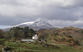
Arenig Fawr is a mountain in Snowdonia, North Wales, close to Llyn Celyn reservoir, alongside the A4212 between Trawsfynydd and Bala.

Foel-fras (944 m) is a mountain in the Carneddau range, about 10 km east of Bethesda in North Wales. It lies on the border between the counties of Gwynedd and Conwy. With a height rising to 944m it is officially the eleventh highest summit in Wales. Foel-fras is located at the northern end of the main ridge of the Carneddau, between Drum to the north and Foel Grach to the south, with the subsidiary summit of Garnedd Uchaf (926 m) between it and Foel Grach. Due south and 400 m below lies the reservoir of Llyn Dulyn, while the smaller reservoir of Llyn Anafon lies to the north.

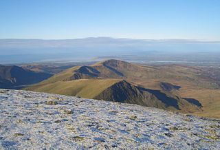
The Snowdon Massif is one of the three mountain groups in Snowdonia, north Wales, to include mountains over 3,000 feet (914 m) high. It occupies the area between Beddgelert, Pen-y-Pass and Llanberis. It is surrounded by the Glyderau to the north-east, Moel Siabod to the east, the Moelwynion to the south, Moel Hebog, the Nantlle Ridge and Mynydd Mawr to the west, and by flatter land leading down to Caernarfon and the Menai Strait to the north-west.
Moel Cynghorion is a mountain in Snowdonia, North Wales. It lies several miles north-west of Snowdon, and forms part of the Moel Eilio Horseshoe walk. The summit is situated on a wide plateau, marked by a pile of stones. The southern slopes are gentle, while the northern aspect is precipitous. The summit has close views of Clogwyn Du'r Arddu and Yr Wyddfa. Views from the summit can extend as far as Holyhead in Anglesey to nearby towns and villages in Gwynedd such as Caernarfon, Llanrug and Llanberis. On a clear day the Wicklow Mountains in Ireland can be seen across the Irish Sea, at a distance of approximately 80 miles away.

The Llanberis Pass in Snowdonia carries the main road (A4086) from the south-east to Llanberis, over Pen-y-Pass, between the mountain ranges of the Glyderau and the Snowdon massif. At the bottom of the pass is the small village of Nant Peris.

Rhobell Fawr is an extinct volcano in the Arenig range within the Snowdonia National Park.
Yr Arddu is a large hill in Snowdonia, Wales. It lies approximately 2.5 km south east of the village of Beddgelert and just over 1 km from the rather more famous mountain Cnicht. It is a rugged hill with widespread rock outcrops and cliffs. A small lake, Llyn yr Arddu, is located on the flanks of the mountain. The recognised summit is at 388m to the South of the hill, but the highest point, named Cerrig-y-Myllt on only the most detailed UK Ordnance Survey mapping, is at 463m above the two small lakes to the North of the hill. The craggy nature of the hill is due to the presence of lavas and tuffs dating from the Ordovician period when Snowdonia was characterised by numerous volcanic eruptions; Yr Arddu is a particularly good location to see the record of Ordovician volcanism. The Yr Arddu Tuffs may be the earliest eruptive phase of the Lower Rhyolitic Tuff Formation.

Carnedd Llechwedd-llyfn is a subsidiary summit of Carnedd y Filiast on the border of Snowdonia National Park in Llandderfel, in Gwynedd. The northern slopes of the peak lie in Ysbyty Ifan, in Conwy. It is part of the Arenig mountain range, and rises from the shore of Llyn Celyn.

Y Gamallt is a mountain located in the Migneint in Snowdonia, North Wales. It forms part of the Arenig mountain range being separated from the Moelwynion range at the head of Cwm Teigl.
The Welsh 1000m Peaks Race takes place on the first Saturday in June each year. The 32 km route is also known as the Snowdonia Summits Marathon as competitors have to reach the top of the all the 1000 metre peaks in Wales.

Clogwyn is an intermediate station on the Snowdon Mountain Railway. It is located on an exposed ridge overlooking the Llanberis Pass and Clogwyn Du'r Arddu cliffs, a popular climbing spot.

Moel y Garnedd is a hill within the Snowdonia National Park in Gwynedd, North Wales.


