Loch Lomond (Algoma District)

Last updated
Loch Lomond
Canada Ontario relief location map.jpg
Red pog.svg
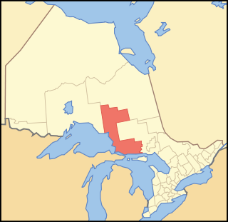
Loch Lomond
Location in Ontario
Location Algoma District, Ontario
Coordinates 48°22′15″N84°11′43″W / 48.37083°N 84.19528°W / 48.37083; -84.19528 Coordinates: 48°22′15″N84°11′43″W / 48.37083°N 84.19528°W / 48.37083; -84.19528 [1]
Etymology Named after Loch Lomond
Part of Great Lakes Basin
Primary inflows Lochalsh River
Primary outflows Lochalsh River
Max. length 3.2 kilometres (2.0 mi)
Max. width 0.7 kilometres (0.43 mi)
Surface elevation 339 metres (1,112 ft) [2]

Loch Lomond is a lake in geographic Glasgow Township [3] in the Unorganized North Part of Algoma District in Northeastern, Ontario, Canada. [1] It is in the Great Lakes Basin and lies within the Chapleau Crown Game Preserve.

Lake A body of relatively still water, in a basin surrounded by land

A lake is an area filled with water, localized in a basin, that is surrounded by land, apart from any river or other outlet that serves to feed or drain the lake. Lakes lie on land and are not part of the ocean, and therefore are distinct from lagoons, and are also larger and deeper than ponds, though there are no official or scientific definitions. Lakes can be contrasted with rivers or streams, which are usually flowing. Most lakes are fed and drained by rivers and streams.

Unorganized North Algoma District Unorganized area in Ontario, Canada

Unorganized North Algoma District is an unorganized area in northeastern Ontario, Canada, comprising all areas in Algoma District, north of the Sault Ste. Marie to Elliot Lake corridor, which are not part of an incorporated municipality or a First Nation. It covers 44,077.03 km2 (17,018.24 sq mi) of land, and had a population of 5739 in 2016.

Algoma District District in Ontario, Canada

Algoma District is a district and census division in Northeastern Ontario in the Canadian province of Ontario.

The primary inflow is the Lochalsh River arriving from Glasgow Lake at the west. The primary outflow, at the east, is also the Lochalsh River, which flows to Dog Lake and then via the Dog River, the Michipicoten River, and the Magpie River to Lake Superior.

Michipicoten River river in Canada

The Michipicoten River is a river in the Algoma District of northern Ontario, Canada, which flows from Dog Lake and joins with the Magpie River to empty into Michipicoten Bay on Lake Superior near the town of Wawa. This river is 113 km (70 mi) in length and drains an area of about 5,200 km2 (2,000 sq mi).

Magpie River (Ontario) watercourse in Canada

The Magpie River is a river in Algoma District, northeastern Ontario, Canada, The river empties into Michipicoten Bay on Lake Superior near the town of Wawa. The river drains an area of about 1,900 square kilometres (734 sq mi).

Lake Superior largest of the Great Lakes of North America

Lake Superior, the largest of the Great Lakes of North America, is also the world's largest freshwater lake by surface area, and the third largest freshwater lake by volume. The lake is shared by the Canadian province of Ontario to the north, the U.S. state of Minnesota to the west, and Wisconsin and the Upper Peninsula of Michigan to the south. The farthest north and west of the Great Lakes chain, Superior has the highest elevation of all five great lakes and drains into the St. Mary's River.

Related Research Articles

Lake Nosbonsing lake in Ontario, Canada

Lake Nosbonsing is a lake in the municipalities of Bonfield, Chisholm, and East Ferris in Nipissing District in Northeastern Ontario, Canada. It is near the City of North Bay, is the source of the Kaibuskong River, and is in the Saint Lawrence River drainage basin.

Loch Lomond (Thunder Bay District) lake in Thunder Bay District, Ontario, Canada

Loch Lomond is a large spring-fed lake located 102 metres (335 ft) above Lake Superior, 6 kilometres (3.7 mi) south of the city of Thunder Bay, Ontario, Canada. It is located in behind Mount McKay, in the Fort William First Nation and Neebing Municipality. Loch Lomond is considered to be a deep oligotrophic lake. The natural re-charge level of Loch Lomond from underground spring water is estimated at 57,100 m3 (12,600,000 imp gal) per day.

Bull Lake (Black River) lake in Sioux Narrows-Nestor Falls, Ontario, Canada

Bull Lake is a lake in geographic Devonshire Township in the municipality of Sioux Narrows-Nestor Falls, Kenora District, Ontario, Canada. It is about 570 metres (1,870 ft) long and 260 metres (853 ft) wide, and lies at an elevation of 358 metres (1,175 ft) about 15 kilometres (9.3 mi) northeast of the community of Sioux Narrows. The primary outflow is an unnamed creek to Mac Lake, whose waters flow via the Black River into Lake of the Woods.

Lake George (Michigan–Ontario) lake on the Canada–United States border (Ontario and Michigan)

Lake George is a lake in Chippewa County, Michigan, United States, and Algoma District, Northwestern Ontario, Canada, that lies between Sugar Island in Michigan on the west and the Ontario mainland on the east.

Misema Lake lake in northeastern Ontario, Canada

Misema Lake is a lake in geographic Katrine and geographic Arnold Township, Timiskaming District in Northeastern Ontario, Canada. It is in the Saint Lawrence River drainage basin and is in the Misema Caldera.

Fallduck Lakes group of lakes in Canada

Fallduck Lakes is a lake in geographic Terry Township, Timiskaming District in Northeastern Ontario, Canada. It is in the Saint Lawrence River drainage basin and is the source of the Englehart River.

Black Lake (Coldwater River) lake in Barager Township, Algoma District, Northeastern Ontario, Canada

Black Lake is a lake in geographic Barager Township in the Unorganized North Part of Algoma District in Northeastern Ontario, Canada. It is part of the Great Lakes Basin, lies entirely within Lake Superior Provincial Park, and is the source of the Coldwater River, which is its primary outflow at the east. The Coldwater River flows to Lake Superior.

Black Lake (Little White River) lake in geographic Le Caron Township, Algoma District, Northeastern Ontario, Canada

Black Lake is a lake in geographic Le Caron Township in the Unorganized North Part of Algoma District in Northeastern Ontario, Canada. It is part of the Great Lakes Basin.

Black River (Abitibi River tributary) river in Canada

The Black River is a river in Cochrane District and Timiskaming District in Northeastern Ontario, Canada. It is part of the James Bay drainage basin, and is a right tributary of the Abitibi River. The municipality of Black River-Matheson is named after the river.

Wolverine Lake (Cochrane District)

Wolverine Lake is a lake in geographic Hanlan Township and geographic Bannerman Township in Cochrane District in Northeastern Ontario, Canada. It is in the James Bay drainage basin and is in the Valentine River system.

Fontaines Landing Unincorporated area in Ontario, Canada

Fontaine's Landing is an unincorporated area in geographic Hanlan Township, Cochrane District in Northeastern Ontario, Canada. The community is counted as part of Unorganized Cochrane North Part in Canadian census data, and is located at the southwest corner of Wolverine Lake where the Valentine River enters the lake, about 15 kilometres (9.3 mi) northwest of Hearst.

Ferguson Lake (Sudbury District)

Ferguson Lake is a lake in geographic Hess Township, Sudbury District in Northeastern Ontario, Canada. It is in the Great Lakes Basin and is the source of Carhess Creek.

Gibson Lake (Pukaskwa River)

Gibson Lake is a lake in Thunder Bay District and Algoma District in Northern Ontario, Canada. It is in the Great Lakes Basin, is the source of the Pukaskwa River, and lies entirely within Pukaskwa National Park. There are three unnamed inflows, at the northwest, northeast and southeast. The primary outflow, at the south, is the Pukaskwa River, which flows to Lake Superior.

Partridge Lake (Fox River)

Partridge Lake is a lake in Thunder Bay District in Northwestern Ontario, Canada. It is in the Great Lakes Basin, and is on the Fox River system. There are three inflows: two unnamed, at the northwest, and the Fox River at the northeast. The primary outflow, at the south, is the Fox River, which flows via the Pukaskwa River to Lake Superior.

Lomond River (Ontario) river in Canada

The Lomond River is a river in the Fort William First Nation and the Municipality of Neebing in Thunder Bay District in Northwestern Ontario, Canada. The river is part of the Great Lakes Basin, and flows from Loch Lomond through a small intermediate lake to Lake Superior.

Gibson Lake (Baldhead River)

Gibson Lake is a lake in geographic Brimacombe Township, Algoma District in Northeastern Ontario, Canada. It is part of the Great Lakes Basin and lies adjacent to and east of Ontario Highway 17 in Lake Superior Provincial Park.

Gibson Lake (Aux Sables River)

Gibson Lake is a lake in geographic Monestime Township and geographic Olynik Township in Algoma District in Northeastern Ontario, Canada. It is part of the Great Lakes Basin and lies about 4 kilometres (2.5 mi) east of the northern terminus of Ontario Highway 810.

Meyers Lake (Ontario)

Meyers Lake is a lake in Cochrane District and Timiskaming District, in northeastern Ontario, Canada. The lake is in the James Bay drainage basin and the nearest community is Bourkes, 4.6 kilometres (2.9 mi) to the northeast.

Swan Lake (Timiskaming District)

Swan Lake is a lake in geographic Lee Township and geographic Maisonville Township in the Unorganized West Part of Timiskaming District, in northeastern Ontario, Canada. The lake is in the James Bay drainage basin and the nearest community is Sesekinika, 4.9 kilometres (3.0 mi) to the northeast. Swan Lake is the location of the mouth of Woollings Creek and is the source of the Whiteclay River.

Hansen Lake (Nipissing District) lake in Temagami, Nipissing District, Ontario, Canada

Hansen Lake is a lake in geographic Chambers Township in the municipality of Temagami, Nipissing District in Northeastern Ontario, Canada. It is in the Great Lakes Basin, and has one named island, Horr Island.

References

  1. 1 2 "Loch Lomond". Geographical Names Data Base. Natural Resources Canada . Retrieved 2014-12-15.
  2. Taken from Google Earth at geographic coordinates, accessed 2014-12-15.
  3. "Glasgow" (PDF). Geology Ontario - Historic Claim Maps. Ontario Ministry of Northern Development, Mines and Forestry . Retrieved 2014-12-15.

Other map sources:

Ministry of Transportation of Ontario government ministry in Ontario

The Ministry of Transportation of Ontario (MTO) is the provincial ministry of the Government of Ontario that is responsible for transport infrastructure and related law in Ontario. The ministry traces its roots back over a century to the 1890s, when the province began training Provincial Road Building Instructors. In 1916, the Department of Public Highways of Ontario (DPHO) was formed and tasked with establishing a network of provincial highways. The first was designated in 1918, and by the summer of 1925, sixteen highways were numbered. In the mid-1920s, a new Department of Northern Development (DND) was created to manage infrastructure improvements in northern Ontario; it merged with the Department of Highways of Ontario (DHO) on April 1, 1937. In 1971, the Department of Highways took on responsibility for Communications and in 1972 was reorganized as the Ministry of Transportation and Communications (MTC), which then became the Ministry of Transportation in 1987.

The Ministry of Municipal Affairs and Housing is the department of the Government of Ontario that is responsible for municipal affairs and housing in the Canadian province of Ontario.