Loddon and Clavering Rural District

Last updated

Boundaries in 1935 Loddon RD 1935.png
Boundaries in 1935

Loddon and Clavering Rural District was a rural district in Norfolk, England from 1894 to 1935, [1] continuing, with very slight boundary changes, as Loddon Rural District until 1974. [2]

Contents

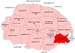
It was formed under the Local Government Act 1894 based on the Loddon and Clavering rural sanitary district, and took its name from the ancient hundreds of Loddon and Clavering. It lay in the south-east corner of the county.

In 1974, the district was abolished under the Local Government Act 1972, and became part of the South Norfolk district.

Statistics

YearArea (ha)

[3] [4]

Population

[5] [6]

Density
(pop/ha)
191124,39212,5500.51
192112,1350.50
193111,8220.48
195124,44612,5810.51
196112,1130.50

Parishes

ParishFromToNotes
Aldeby
Alpington
Ashby St Mary
Bedingham
Bergh Apton
Brooke
Broome
Burgh St Peter
Carleton St Peter
Chedgrave
Claxton
Ditchingham
Ellingham
Geldeston
Gillingham
Haddiscoe
Hales
Hardley 1935Component of Langley with Hardley
Heckingham
Hedenham
Hellington
Howe
Kirby Cane
Kirstead
Langley 1935See next
Langley with Hardley 1935Merger
Loddon
Mundham
Norton Subcourse
Raveningham
Seething
Sisland
Stockton
Thorpe-next-Haddiscoe 1935Added to Haddiscoe
Thurlton
Thurton
Thwaite
Toft Monks
Topcroft
Wheatacre
Woodton
Yelverton

References

  1. "Loddon and Clavering RD through time: Census tables with data for the Local Government District". A Vision of Britain through Time. GB Historical GIS / University of Portsmouth. Retrieved 1 July 2017.
  2. "Loddon RD through time: Census tables with data for the Local Government District". A Vision of Britain through Time. GB Historical GIS / University of Portsmouth. Retrieved 1 July 2017.
  3. "Loddon and Clavering RD through time: Population Statistics: Area (acres)". A Vision of Britain through Time. GB Historical GIS / University of Portsmouth. Retrieved 1 July 2017.
  4. "Loddon RD through time: Population Statistics: Area (acres)". A Vision of Britain through Time. GB Historical GIS / University of Portsmouth. Retrieved 1 July 2017.
  5. "Loddon and Clavering RD through time: Population Statistics: Total Population". A Vision of Britain through Time. GB Historical GIS / University of Portsmouth. Retrieved 1 July 2017.
  6. "Loddon RD through time: Population Statistics: Total Population". A Vision of Britain through Time. GB Historical GIS / University of Portsmouth. Retrieved 1 July 2017.

52°32′N1°29′E / 52.53°N 1.48°E / 52.53; 1.48