Long Island (Nova Scotia)

Last updated

Long Island looking northward Long Island Nova Scotia - Looking northward.jpg
Long Island looking northward
Long Island (Nova Scotia)
This is a stopgap mapping solution, while attempts are made to resolve technical difficulties with {{ OSM Location map }}
Location in the Bay of Fundy
Long Island (Nova Scotia)
This is a stopgap mapping solution, while attempts are made to resolve technical difficulties with {{ OSM Location map }}
Long Island in relation to Digby Neck and Brier Island

Long Island is a Canadian island in Digby County, Nova Scotia.

Situated in the Bay of Fundy immediately southwest of the Digby Neck, Brier Island is located immediately west. Long Island is separated from the Digby Neck by the "Petit Passage" and from Brier Island by the "Grand Passage".

Route 217 runs the length of Long Island from the ferry crossing at Tiverton at the eastern end of the island (connecting to East Ferry on the Digby Neck) to the ferry crossing at Freeport at the western end of the island (connecting to Westport).

Long Island is approximately 15 km long and 5 km wide and is primarily basalt rock of the North Mountain ridge. The southern coast (St. Mary's Bay side) of the island is mostly faced with steep cliffs with the north coast (Bay of Fundy side) featuring smaller cliffs and round-rock beaches. There are several coves along both sides with Bear Cove (in Tiverton), Israel's Cove (also known as Pirate's Cove, located in Tiverton), Flour Cove (central on the island), and Beautiful Cove (in Freeport) being the best known and easily accessed coves.

There are two shallow lakes located together in the centre of the island with a small brook leading in either directions and ending on either end of the island, one in Tiverton and the other in Freeport.

There is a tidal bore that occurs on the outgoing (ebb) tide in St. Mary's Bay just south of Petit Passage that is commonly referred to as The Bull.

Long Island was first discovered by the explorer Samuel de Champlain in 1604 but was not settled until the late 18th century when the land was granted to British loyalists who fought for the British against the Americans in the American Revolution.

The primary industry is lobster catching with a season running from the last Monday in November until the last day of May. A second, and growing industry, is tourism. The Bay of Fundy is known for whale watching and Long Island offers several tour operator throughout the summer months. Another attraction is Balancing Rock, a large basalt column that appears to be balancing on its end on the southern shore just outside Tiverton.

It also has commonly-sighted deer, sea birds, and as of 2013 a bear which had not previously been seen for a century. Sometimes whales can be seen from the water's edge.
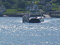
See also

44°19′35″N66°16′22″W / 44.32639°N 66.27278°W / 44.32639; -66.27278

Related Research Articles

<span class="mw-page-title-main">Bay of Fundy</span> Bay on the east coast of North America

The Bay of Fundy is a bay between the Canadian provinces of New Brunswick and Nova Scotia, with a small portion touching the U.S. state of Maine. It is an arm of the Gulf of Maine. Its tidal range is the highest in the world. The name is probably a corruption of the French word fendu, meaning 'split'.

<span class="mw-page-title-main">Digby County, Nova Scotia</span> County in Nova Scotia, Canada

Digby County is a county in the Canadian province of Nova Scotia.

<span class="mw-page-title-main">Minas Basin</span>

The Minas Basin is an inlet of the Bay of Fundy and a sub-basin of the Fundy Basin located in Nova Scotia, Canada. It is known for its extremely high tides.

<span class="mw-page-title-main">Westport, Nova Scotia</span>

Brier Island is an island in the Bay of Fundy in Digby County, Nova Scotia.

<span class="mw-page-title-main">Annapolis Basin</span>

The Annapolis Basin is a sub-basin of the Bay of Fundy, located on the bay's southeastern shores, along the northwestern shore of Nova Scotia and at the western end of the Annapolis Valley.

Freeport is a village in Digby County, Nova Scotia and it is located on Long Island in the Bay of Fundy.

<span class="mw-page-title-main">Nova Scotia Route 217</span>

Route 217 is a collector road in the Canadian province of Nova Scotia.

<span class="mw-page-title-main">St. Marys Bay, Nova Scotia</span> Bay in Nova Scotia, Canada

St. Marys Bay south western Nova Scotia, Canada, is surrounded by the modern municipal districts of Clare Municipal District and Digby.

<span class="mw-page-title-main">Tiverton, Nova Scotia</span> Village in Nova Scotia, Canada

Tiverton is a small village located on the northeast tip of Long Island, Nova Scotia. Tiverton has a population of about 300 people. It was named for Tiverton, Devon.

Digby Neck is a Canadian peninsula extending into the Bay of Fundy in Digby County, Nova Scotia.

<span class="mw-page-title-main">Nova Scotia peninsula</span> Peninsula in Nova Scotia

The Nova Scotia peninsula is a peninsula on the Atlantic coast of North America.

<span class="mw-page-title-main">Municipality of the District of Digby</span> District municipality in Nova Scotia, Canada

Digby, officially named the Municipality of the District of Digby, is a district municipality in Digby County, Nova Scotia, Canada. Statistics Canada classifies the district municipality as a municipal district.

<span class="mw-page-title-main">North Mountain (Nova Scotia)</span> Mountain range in Nova Scotia, Canada

North Mountain is a narrow southwest-northeast trending volcanic ridge on the mainland portion of southwestern Nova Scotia, stretching from Brier Island to Cape Split. It forms the northern edge of the Annapolis Valley along the shore of the Bay of Fundy. Together with South Mountain, the two ranges form the Annapolis Highlands region.

Cape St. Marys is a headland located at the western tip of the Nova Scotia peninsula in the Canadian province of Nova Scotia.

Joseph Henry Casey was a fish plant operator, steamship pilot and political figure in Nova Scotia, Canada. He represented Digby and then Digby-Annapolis in the Nova Scotia House of Assembly from 1970 to 1984 and from 1988 to 1997 as a Liberal member.

<span class="mw-page-title-main">Digby Gut</span>

The Digby Gut is a narrow channel connecting the Bay of Fundy with the Annapolis Basin. The town of Digby, Nova Scotia is located on the inner portion of the western side of the Gut. The eastern entrance is marked by the Point Prim Lighthouse. Strong tidal currents, numerous rocky ledges, frequent fogs and unpredictable winds make it a dangerous passage requiring a pilot or local knowledge. Tide flows create 5 knot tidal currents and create numerous whirlpools and eddies. The gut is about a half nautical mile in width and bordered by high rocky cliffs. It marks a break in the North Mountain ridge along the Annapolis Valley and is the eastern end of Digby Neck. Digby Gut had its origins as the northern terminus of the ancient Bear River, part of which is now a drowned river valley.

<span class="mw-page-title-main">Outline of Nova Scotia</span> Overview of and topical guide to Nova Scotia

The following outline is provided as an overview of and topical guide to Nova Scotia: