Looe Bridge

Last updated

Looe Bridge
Looe Bridge (9911).jpg
The downstream face of Looe Bridge (pictured in 2011)
Coordinates 50°21′22″N4°27′21″W / 50.3562°N 4.4559°W / 50.3562; -4.4559 Coordinates: 50°21′22″N4°27′21″W / 50.3562°N 4.4559°W / 50.3562; -4.4559
OS grid reference SX 25395 53584
Carries A387 road
Crosses River Looe
Locale Looe, Cornwall
Heritage status Grade II listed
Preceded by Terras Bridge
Characteristics
Design Arch bridge
Material Slatestone, granite
No. of spans9
Piers in water6
History
ArchitectWilliam Pease
Construction start1854
Construction end1855
Construction cost£2,984 (equivalent to £286,346in 2020)
Opened4 September 1855
Location
Looe Bridge

Looe Bridge is a bridge in Looe, Cornwall, across the River Looe. Built in the 1850s to replace a dangerous 15th-century structure, the bridge carries the A387 road and is a Grade II listed building.

Contents

History

Early crossing (c. 1400–1405)

An early wooden bridge was built across the river at Looe in c.1400. This structure burned down in 1405. [1]

Medieval bridge (1411–1853)

A plaque in West Looe commemorating the 1689 repairs to the old bridge Old Bridge Marker on Quay Road, West Looe (geograph 6945617 by T Jenkinson).jpg
A plaque in West Looe commemorating the 1689 repairs to the old bridge

The first stone bridge across the river in the town was built following a grant of 22 October 1411; construction took 25 years and was completed in 1436. [2] [lower-alpha 1] Most descriptions of the bridge give its length as 384 ft (117 m), [2] [4] although publication of 1847 described it as being 423 ft (129 m) long. [5] Similarly disputed is the number of arches the bridge had – reports by John Leland describe either 12 or 16, [2] The Gentleman's Magazine listed 13, [6] Celia Fiennes referred to its 14 arches, [7] William Borlase sketched [8] and the National Heritage List for England states 15, [9] and Thomas Bond specified 18. [2] The arches varied in width from 9–22 ft (2.7–6.7 m); the larger spans allowed passage of timber rafts. The width of the bridge was 6 ft 8 in (2.03 m) at its narrowest and 10 ft 3 in (3.12 m) at its widest. On the centre of the bridge was a chapel dedicated to Saint Anne; the first mention of the chapel is from 18 November 1436 when the chaplain obtained a license from Edmund Lacey to hold a wedding there. [4] [8] It is possible that the chapel was demolished at the time of the Reformation, [8] although some traces were reported to have still existed when the bridge was demolished. [2] In 1689 the bridge was "in general decay", and the repairs were seen to by the county authority. Granite plaques were installed at each end of the bridge, of which the west plaque still exists. [10]

In 1478, William of Worcester referred to the bridge as Low Brygge, and described it as maximus pons – i.e. the largest bridge in Cornwall. [11] [12] In 1508, wealthy Cornwall merchant Thomas Yogge bequeathed a hundredweight (112 lb or 51 kg) of salt for repairs to the bridge, provided that the town of Loo [ sic ] brought it from Plymouth at the town's own expense. [11] [13] A notice placed in The London Gazette in 1847 stated of an intent to apply to parliament to improve and maintain Looe Harbour, and to "take down the bridge across the said harbour, and to build a new bridge instead thereof, with proper approaches and works connected therewith, at or near the site of the present bridge". [14] The following year, the East and West Looe Harbour and Bridge Act was passed, which stated that "the present bridge across the harbour is dilapidated and ill built". [15] A similar description of the old structure said that it was a "narrow time-eaten bridge [that] had become ruinous and dangerous". [16] Conversely, a more contemporary report described it as "a very fine mediaeval bridge". [11] Henderson and Coates suggested that had the narrowest part of the bridge been 9 ft (2.7 m) like that at Wadebridge, it would have been spared – and that it was "a thousand pities" the builders had not done so. [11] [17]

Victorian bridge (1854–present)

A grant for constructing a new bridge was made in 1852. Built approximately 100 yd (91 m) upstream of the site of the older bridge, which had been removed in 1853, [2] the foundation stone was laid on 16 June 1854 and the new bridge opened on 4 September 1855. [4] Designed by William Pease [18] of slatestone with granite dressings, [9] the bridge cost £2,984 (equivalent to £286,346in 2020) to construct. It has nine "misshapen" arches, [11] of which seven span the river, one is a dry arch on the East Looe side, and one at the West Looe side forms a pedestrian passage. [4] [9] The roadway had an original uniform width of 18 ft 2 in (5.54 m), [4] but underwent a programme of widening in the late 1950s and early 1960s. [19] [20] [21]

The road carried by the bridge forms part of the A387 between Polbathic and Polperro. [19] In 1993, the bridge and its six cast iron lamp standards were given Grade II listed status. [9]

Footnotes

  1. One source states that construction completed in 1411, having begun in 1405 [3]

Related Research Articles

Looe Island

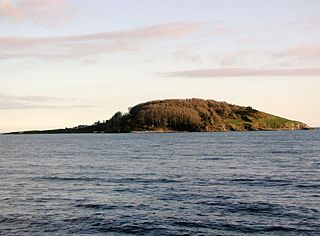
Looe Island, also known as St George's Island, and historically St Michael's Island is a small island nature reserve a mile from the mainland town of Looe off Cornwall, England.

Polruan Human settlement in England

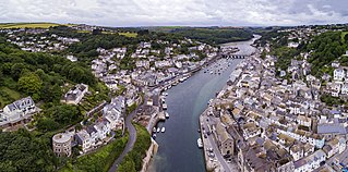
Polruan is a small fishing village in the parish of Lanteglos-by-Fowey in Cornwall, England, United Kingdom. It is bounded on three sides by water: to the north by Pont Creek, to the west by the River Fowey and to the south by the English Channel and neighbours village Bodinnick to the north, connected by a 4-mile walk along the hill tops. Polruan is very steep and well protected from the prevailing winds and Polruan Pool is a haven for small boats.

Looe Human settlement in England

Looe is a coastal town and civil parish in south-east Cornwall, England, with a population of 5,280 at the 2011 census.

River Avon, Bristol River in the south west of England

The River Avon is a river in the south west of England. To distinguish it from a number of other rivers of the same name, it is often called the Bristol Avon. The name 'Avon' is a cognate of the Welsh word afon, meaning 'river'.

South West Coast Path Long distance footpath in England

The South West Coast Path is England's longest waymarked long-distance footpath and a National Trail. It stretches for 630 miles (1,014 km), running from Minehead in Somerset, along the coasts of Devon and Cornwall, to Poole Harbour in Dorset. Because it rises and falls with every river mouth, it is also one of the more challenging trails. The total height climbed has been calculated to be 114,931 ft (35,031 m), almost four times the height of Mount Everest. It has been voted 'Britain's Best Walking route' twice in a row by readers of The Ramblers' Walk magazine, and regularly features in lists of the world's best walks.

River Camel River in Cornwall, England

The River Camel is a river in Cornwall, United Kingdom. It rises on the edge of Bodmin Moor and with its tributaries its catchment area covers much of North Cornwall. The river flows into the eastern Celtic Sea between Stepper Point and Pentire Point having covered about 30 miles, making it the second longest river wholly in Cornwall. The river is tidal upstream to Egloshayle and is popular for sailing, birdwatching and fishing. The name Camel comes from the Cornish language for 'the crooked one', a reference to its winding course. Historically the river was divided into three named stretches. Heyl was the name for the estuary up to Egloshayle, the River Allen was the stretch between Egloshayle and Trecarne, whilst the Camel was reserved for the stretch of river between its source and Trecarne.

Saltash Town in Cornwall, United Kingdom

Saltash is a town and civil parish in south Cornwall, England, United Kingdom. It had a population of 16,184 in 2011 census. Saltash faces the city of Plymouth over the River Tamar and is popularly known as "the Gateway to Cornwall". Saltash’s landmarks include the Tamar Bridge which connects Plymouth to Cornwall by road, and the Royal Albert Bridge. The area of Latchbrook is part of the town.

Polperro Human settlement in England

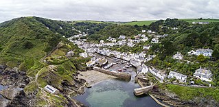
Polperro is a large village, civil parish, and fishing harbour within the Polperro Heritage Coastline in south Cornwall, England. Its population is around 1,554.

Looe Valley Line

The Looe Valley Line is an 8+34 miles (14 km) community railway from Liskeard to Looe in Cornwall, United Kingdom, that follows the valley of the East Looe River for much of its course. It is operated by Great Western Railway.

Talland

Talland is a hamlet and ecclesiastical parish between Looe and Polperro on the south coast of Cornwall. It is in the civil parish of Polperro and consists of a church, the Old Vicarage and a few houses.

Cornwall Railway viaducts

The Cornwall Railway company constructed a railway line between Plymouth and Truro, England, opening in 1859, and extended it to Falmouth in 1863. The topography of Cornwall is such that the route, which is generally east-west, cuts across numerous deep river valleys that generally run north-south. At the time of construction of the line, money was in short supply due to the collapse in confidence following the railway mania, and the company sought ways of reducing expenditure.

Looe railway station Railway station in Cornwall, England

Looe railway station serves the twin towns of East and West Looe, in Cornwall, England. The station is the terminus of the scenic Looe Valley Line 8.75 miles (14 km) south of Liskeard.

Hessenford Human settlement in England

Hessenford is a small village in south-east Cornwall, United Kingdom, four miles west of St Germans on the A387 Polbathic to Polperro road. The village had a population of 170 at the 2001 census. It is in the civil parish of Deviock. The river Seaton runs through the village and a mill was recorded here in 1286; the last mill closing in the mid-20th century.

Lansallos Human settlement in England

Lansallos is a village in the civil parish of Polperro in south Cornwall, England, United Kingdom. It is situated between Polruan and Polperro about 5 miles (8 km) east of Fowey in Liskeard Registration District.

Gribben Head Headland on the south coast of Cornwall, England

Gribbin Head is a promontory on the south coast of Cornwall, England, UK, owned and managed by the National Trust. It separates St Austell Bay from the estuary of the River Fowey and is marked by a large tower used to aid navigation of ships approaching the local harbours. The nearest town is Fowey. The western point of the headland is called Little Gribbin.

Fishing in Cornwall, England, UK, has traditionally been one of the main elements of the economy of the county. Pilchard fishing and processing was a thriving industry in Cornwall from around 1750 to around 1880, after which it went into an almost terminal decline. During the 20th century the varieties of fish taken became much more diverse and crustaceans such as crab and lobster are now significant. Much of the catch is exported to France due to the higher prices obtainable there. Though fishing has been significantly damaged by overfishing, the Southwest Handline Fishermen's Association has started to revive the fishing industry. As of 2007, stocks are improving. The Cornwall Sea Fisheries Committee is one of 12 such committees responsible for managing the corresponding Sea Fisheries District. The Isles of Scilly Sea Fisheries Committee is responsible for the Scilly district.

Terras Bridge Road bridge over the River Looe in Cornwall, England

Terras Bridge, also known as Terras Pill Bridge, is a road bridge near Morval in Cornwall, England. Built in c. 1825, the Grade II listed bridge crosses the tidal East Looe River, and is adjacent to the Liskeard and Looe Railway and the remains of the Liskeard and Looe Union Canal.

Polruan to Polperro

Polruan to Polperro is a coastal Site of Special Scientific Interest (SSSI) and Special Area of Conservation (SAC) in south-east Cornwall, England, UK, noted for its biological interest. It contains a wide variety of plant species and is a site for populations of breeding birds.

Joseph Thomas (1838-1901) was a Cornish architect, civil engineer and entrepreneur who lived the majority of his life in Looe. He made a number of significant contributions to the development of the town in the late 19th century, including the design of the Banjo Pier and the creation of the Hannafore estate.

Respryn Bridge Bridge over the River Fowey in Cornwall

Respryn Bridge is a 15th-century granite and stone bridge over the River Fowey in the parish of Lanhydrock in Cornwall, England. The bridge is a Grade II* listed building.

References

  1. Mikhailova, Ekaterina; Garrard, John (29 November 2021). Twin Cities across Five Continents: Interactions and Tensions on Urban Borders. Abingdon, Oxon: Routledge. ISBN   978-1-000-47911-9 . Retrieved 11 January 2022.
  2. 1 2 3 4 5 6 "Looe Bridge And St Annes Chapel". www.heritagegateway.org.uk. Heritage Gateway. Retrieved 11 January 2022.
  3. "Cornwall Industrial Settlements Initiative LOOE" (PDF). Cornwall County Council. April 2002. Archived from the original (PDF) on 10 January 2022. Retrieved 10 January 2022.
  4. 1 2 3 4 5 Polsue, Joseph (1870). A Complete Parochial History of the County of Cornwall (Volume 3). Lake. p. 166. Retrieved 11 January 2022.
  5. Wallis, John (1847). The Cornwall register, containing collections relative to the past and present state of the 209 parishes. p. 367. Retrieved 11 January 2022.
  6. "Compendium of County History". The Gentleman's Magazine. 123: 410. 1818. Retrieved 11 January 2022.
  7. Fiennes, Peter (2019). Footnotes : a journey round Britain in the company of great writers. London. ISBN   9781786076304.
  8. 1 2 3 "LOOE - Medieval chapel, Medieval bridge". www.heritagegateway.org.uk. Heritage Gateway. Retrieved 11 January 2022.
  9. 1 2 3 4 Historic England. "BRIDGE OVER EAST LOOE RIVER AND LAMP STANDARDS (1201093)". National Heritage List for England .
  10. Bond, Thomas (1823). Topographical and Historical Sketches of the Boroughs of East and West Looe, in the County of Cornwall. J. Nichols and Son. pp. 9–10. Retrieved 11 January 2022.
  11. 1 2 3 4 5 Henderson, Charles; Coates, Henry (1928). Old Cornish Bridges and Streams. University College of the South West. pp. 67–69. Retrieved 11 January 2022.
  12. Keast, John (1987). A history of East and West Looe. Chichester, Sussex: Phillimore. p. 12. ISBN   9780850336153 . Retrieved 11 January 2022.
  13. Historic England. "PRYSTEN HOUSE (1067152)". National Heritage List for England .
  14. "Notices". The London Gazette: 4428. 22 October 1847.
  15. "East and West Looe Harbour and Bridge Act 1848". vLex. vLex Justis. Retrieved 10 January 2022.
  16. Allen, John (1856). History of the Borough of Liskeard and Its Vicinity. Cash. p. 403.
  17. Harrison, David (2004). The Bridges of Medieval England: transport and society, 400-1800. Oxford: Clarendon Press. p. 153. ISBN   9780199272747.
  18. Keast, John (1987). A history of East and West Looe. Chichester, Sussex: Phillimore. p. 74. ISBN   9780850336153.
  19. 1 2 Pope, Rita Tregellas (2002). Cornwall and the Isles of Scilly (3rd ed.). Ashbourne: Landmark Publishing Limited. p. 44. ISBN   9781843060345.
  20. "Widening of Looe Bridge on Looe-Polperro Road, Corn". The National Archives. 1958–1959. Retrieved 10 January 2022.
  21. "They Built Upon Sand". Municipal Journal, Public Works Engineer Contractor's Guide: 190. 1960.