Lorengecora

Last updated

Lorengecora
Uganda location map.svg
Red pog.svg
Lorengecora
Map of Uganda showing the location of Lorengecora.
Coordinates: 02°14′04″N34°15′57″E / 2.23444°N 34.26583°E / 2.23444; 34.26583 Coordinates: 02°14′04″N34°15′57″E / 2.23444°N 34.26583°E / 2.23444; 34.26583
CountryFlag of Uganda.svg  Uganda
District Napak District
Elevation
1,162 m (3,812 ft)
Time zone UTC+3 (EAT)

Lorengecora is a settlement in the Northern Region of Uganda. [1] It is the headquarters of Lorengecora Parish, in Iriri sub-county, in Bokora County, in Napak District, in the Karamoja sub-region. [1] [2]

Contents

Location

Lorengecora Town Council is located along the Soroti–Katakwi–Moroto–Lokitanyala Road, approximately 111 kilometres (69 mi), by road, northeast of Soroti. [3] The town is about 62 kilometres (39 mi), by road, southwest of Moroto Town, the largest town in the Karamoja sub-region. [4] This location is within the Bokora Corridor Wildlife Reserve, approximately 400 kilometres (249 mi), by road, northeast of Kampala, the largest city and capital of Uganda. [5] The geographical coordinates of Lorengecora Town Council are 02°14'04.0"N, 34°15'57.0"E (Latitude:2.234444; Longitude:34.265833). [6] Lorengecora is situated at an average elevation of 1,162 metres (3,812 ft), above sea level. [7]

Overview

Lorengecora Town Council was created, effective 14 July 2011. [8] In 2015, a study carried out by a non-government organisation, called African Network for the Prevention and Protection against Child Abuse and Neglect (ANPPCAN), on the streets of Kampala, found that 57 percent of all Kampala street children come from the Karamoja sub-region. Also, 44 percent of the same cohort, come from Napak District. [9]

Efforts to resettle the nomadic children back in their home area, have focused in Lorengecora Town Council, where attempts are made to enroll in school and house the returnees at Kobulin Resettlement Camp in Napak District. [10] [11]

See also

Related Research Articles

Kotido District District in Uganda

Kotido District is a district in Northern Uganda. It is named after its 'chief town', Kotido, where the district headquarters are located.

Moroto District District in Uganda

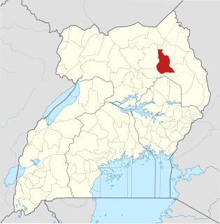
Moroto District is a district in the Northern Region of Uganda. The town of Moroto is the site of the district headquarters.

Moroto Town Place in Northern Region, Uganda

Moroto is a town in Moroto District in the Northern Region of Uganda. It is the location of the district headquarters.

Kotido Place in Uganda

Kotido is a town in the Northern Region of Uganda. It is the chief municipal, administrative, and commercial center of the Kotido District and the site of the district headquarters.

Nakapiripirit Place in Uganda

Nakapiripirit is a town in the Nakapiripirit District of the Northern Region of Uganda. It is the seat of the district headquarters. The town is an administrative unit of the district, at the level of a sub-county; one of the eight sub-counties in the district.

Kaabong District District in Uganda

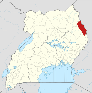
Kaabong District is a district in the Northern Region of Uganda. The district headquarters are in the town of Kaabong.

Abim District District in Uganda

Abim District is a district in Northern Uganda. It's named after its 'chief town', Abim, where the district headquarters are located.

Abim, Uganda Place in Northern Uganda, Uganda

Abim is a town in the Northern Region of Uganda. It is the chief municipal, administrative, and commercial center of Abim District.

Kaabong Place in Uganda

Kaabong is a town in the Northern Region of Uganda. It is the chief municipal, administrative and commercial center of Kaabong District, and the district headquarters are located there.

Moroto Regional Referral Hospital, commonly known as Moroto Hospital is a hospital in the town of Moroto, in Northeastern Uganda. It is the referral hospital for the districts of Abim, Kaabong, Kotido, Moroto and Nakapiripirit and Napak.

Amudat District District in Uganda

Amudat District is a district in Northern Uganda. Like most other Ugandan districts, it is named after its 'chief town', Amudat, where the district headquarters are located.

Napak District District in Northern Uganda, Uganda

Napak District is a district in Northern Uganda. It is named after Mount Napak, and its headquarters is at Lokitede.

Napak Place in Uganda

Napak is a town in Northern Uganda. It is the commercial, administrative and municipal headquarters of Napak District. The district is named after the town.

Moroto Cement Limited (MCL), whose full name is Moroto Cement Industries Limited, is a manufacturer of cement in Uganda with approximately 3000 tonnes per day clinker capacity.

Kimwanyi Place in Wakiso District, Uganda

Kimwanyi is a neighborhood in Kira Municipality, Wakiso District, in the Buganda Region of Uganda. Kimwanyi also refers to Kimwanyi Parish, in Kira sub-county, Kyaddondo County, Wakiso District. It is one of the six parishes (wards) of Kira Municicipality, namely; Kimwanyi, Kira, Kyaliwajjala, Kireka, Bweyogerere and Kirinnya.

Soroti–Katakwi–Moroto–Lokitanyala Road is a road in the Eastern and Northern regions of Uganda. The road connects the urban centers of Soroti, the largest city in Teso sub-region, to Katakwi, the district headquarters of Katakwi District and to Moroto, the largest city in the Karamoja sub-region. It ends at Lokitanyala, at the international border with Kenya.

Katakwi General Hospital, also Katakwi Hospital is a government-owned hospital in the Eastern Region of Uganda.

Kaabong General Hospital, also Kaabong District Hospital, is a public hospital in the Northeastern Region of Uganda.

Kijabijo Place in Buganda, Uganda

Kijabijo is a neighborhood in Kira Town, in Wakiso District in the Buganda Region of Uganda.

The Opuyo–Moroto High Voltage Power Line is a high voltage electricity power line, under construction, connecting the high voltage substation at Opuyo, a southern suburb of the town of Soroti, in the Eastern Region to another high voltage substation at Moroto, in the Northern Region of Uganda.

References

  1. 1 2 Places in the World (11 June 2018). "Places in the World: Lorengecora, Uganda". Places-in-the-world.com. Retrieved 11 June 2018.
  2. Lcmt.org (11 June 2018). "Uganda Directory: Lorengecora Parish, Iriiri Subcounty, Napak District, Uganda". Land Conflict Mapping Tool Organization (Lcmt.org). Retrieved 11 June 2018.
  3. Globefeed.com (11 June 2018). "Distance between Soroti Regional Police Headquarters, Soroti, Uganda and Lorengecora Town Council, Uganda". Globefeed.com. Retrieved 11 June 2018.
  4. Globefeed.com (11 June 2018). "Distance between Lorengecora Town Council, Uganda and Moroto Police Station, Moroto, Uganda". Globefeed.com. Retrieved 11 June 2018.
  5. Globefeed.com (11 June 2018). "Distance between Uganda Post Office, Kampala Road, Kampala, Uganda and Lorengecora Town Council, Uganda". Globefeed.com. Retrieved 11 June 2018.
  6. Google (11 June 2018). "Location of Lorengecora Town Council, Napak District, Uganda" (Map). Google Maps . Google. Retrieved 11 June 2018.
  7. Mapcarta (11 June 2018). "Elevation of Lorengecora, Uganda". Mapcarta.com. Retrieved 11 June 2018.
  8. Adolf Mwesige, Minister of Local Government (3 February 2012). "Local Government (Declaration of Towns) Regulations, 2012" (PDF). Kampala: Uganda Legal Information Institute (ULII). Retrieved 11 June 2018.
  9. ANPPCAN Uganda (2015). "Summary of Situation Analysis of children living on the streets in Uganda". Kampala: African Network for the Prevention and Protection against Child Abuse and Neglect (ANPPCAN). Retrieved 11 June 2018.
  10. Oketch, Bill (30 May 2018). "How Karimojong parents fuel begging on Kampala streets". Daily Monitor . Kampala. Retrieved 11 June 2018.
  11. Mary Sundal (May 2010). "Nowhere to Go: Karimojong Displacement and Forced Resettlement" (DOI: 10.3167/np.2010.140205). Nomadic Peoples. 14 (2): 72–86. doi:10.3167/np.2010.140205 . Retrieved 11 June 2018.