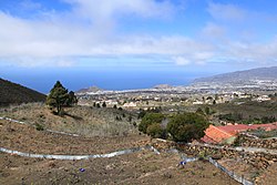
La Palma, also known as La isla bonita and historically San Miguel de La Palma, is the most northwesterly island of the Canary Islands, Spain. La Palma has an area of 708 square kilometres (273 sq mi) making it the fifth largest of the eight main Canary Islands. The total population at the end of 2020 was 85,840, of which 15,716 lived in the capital, Santa Cruz de La Palma and about 20,467 in Los Llanos de Aridane. Its highest mountain is the Roque de los Muchachos, at 2,426 metres (7,959 ft), being second among the peaks of the Canaries after the Teide massif on Tenerife.

Lanzarote is a Spanish island, the easternmost of the Canary Islands in the Atlantic Ocean, 125 kilometres off the north coast of Africa and 1,000 kilometres from the Iberian Peninsula. Covering 845.94 square kilometres, Lanzarote is the fourth-largest of the islands in the archipelago. With 152,289 inhabitants at the start of 2019, it is the third most populous Canary Island, after Tenerife and Gran Canaria. Located in the centre-west of the island is Timanfaya National Park, one of its main attractions. The island was declared a biosphere reserve by UNESCO in 1993. The island's capital is Arrecife, which lies on the eastern coastline. It is the smaller main island of the Province of Las Palmas.
A monogenetic volcanic field is a type of volcanic field consisting of a group of small monogenetic volcanoes, each of which erupts only once, as opposed to polygenetic volcanoes, which erupt repeatedly over a period of time. The small monogenetic volcanoes of these fields are the most common subaerial volcanic landform.
The Cumbre Vieja is an active volcanic ridge on the island of La Palma in the Canary Islands, Spain. The spine of Cumbre Vieja trends in an approximate north–south direction, comprising the southern half of La Palma, with both summit ridge and flanks pockmarked by dozens of craters and cones. The latest eruption began on 19 September 2021 in a forested area of Las Manchas locality known as Cabeza de Vaca. Voluminous lava flows quickly reached populated areas downslope, fanning out across settlements and banana plantations, destroying thousands of buildings and ultimately pouring over steep cliffs into the ocean to enlarge the island at several locations. The volcano went quiet on 13 December 2021, and on 25 December 2021, the local government declared the eruption to be over.

In volcanology, a Strombolian eruption is a type of volcanic eruption with relatively mild blasts, typically having a Volcanic Explosivity Index of 1 or 2. Strombolian eruptions consist of ejection of incandescent cinders, lapilli, and volcanic bombs, to altitudes of tens to a few hundreds of metres. The eruptions are small to medium in volume, with sporadic violence. This type of eruption is named for the Italian volcano Stromboli.

Fuencaliente de La Palma, also Fuencaliente, is a municipality in the southern part of the island La Palma in the province of Santa Cruz de Tenerife of the Canary Islands, Spain. The seat of the municipality is the village Los Canarios. It has been the seat since 1837. The population of the municipality is 1,798 (2013) and the area is 56.42 km².
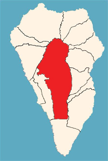
El Paso, also known as Ciudad de El Paso, is a Spanish municipality located on the island of La Palma, province of Santa Cruz de Tenerife, Canary Islands.

La Palma Airport is an airport located in Breña Baja and Villa de Mazo, 8 km (5.0 mi) south of the city of Santa Cruz de La Palma on La Palma in the Canary Islands. It is operated by Aeropuertos Españoles y Navegación Aérea (AENA), who operate the majority of civil airports in Spain.

Teneguía is a monogenetic cinder cone – a volcanic vent which has been active once and has had further seismic activity. It is situated on the island of La Palma, one of the Canary Islands, and is located at the southern end of the sub-aerial section of the Cumbre Vieja volcano, of which Teneguía is just one of several vents.

The Canary hotspot, also called the Canarian hotspot, is a hotspot and volcanically active region centred on the Canary Islands located off the north-western coast of Africa. Hypotheses for this volcanic activity include a deep mantle plume beginning about 70 million years ago. The underwater El Hierro and subaerial Cumbre Vieja eruptions remain the most recent Canarian eruptions.

Lava is molten or partially molten rock (magma) that has been expelled from the interior of a terrestrial planet or a moon onto its surface. Lava may be erupted at a volcano or through a fracture in the crust, on land or underwater, usually at temperatures from 800 to 1,200 °C. The volcanic rock resulting from subsequent cooling is also often called lava.
The 2011–2012 El Hierro eruption occurred just off the island of El Hierro, the smallest and farthest south and west of the Canary Islands, in the Atlantic Ocean off the coast of Africa. The island is also the youngest in the volcanic chain. The October 2011 – March 2012 eruption was underwater, with a fissure of vents located approximately 2 kilometres to the south of the fishing village of La Restinga on the southern coast of the island. Increased seismicity in June 2012 to the north-west of the vent did not result in another phase of eruptive activity. Until the 2021 La Palma eruption, which started on 19 September 2021, this was the last volcanic eruption in Spain.

The geology of the Canary Islands is dominated by volcanic rock. The Canary Islands and some seamounts to the north-east form the Canary Volcanic Province whose volcanic history started about 70 million years ago. The Canary Islands region is still volcanically active. The most recent volcanic eruption on land occurred in 2021 and the most recent underwater eruption was in 2011-12.

An eruption at the Cumbre Vieja volcanic ridge, comprising the southern half of the Spanish island of La Palma in the Canary Islands, took place between 19 September and 13 December 2021. It was the first volcanic eruption on the island since the eruption of Teneguía in 1971. At 85 days, it is the longest known and the most damaging volcanic eruption on La Palma since records began. The total damage caused by the volcano amounts up to 843 million euros.

Las Manchas is a locality in the municipalities of El Paso and Los Llanos de Aridane on the island of La Palma. It is an area of historical and geographical interest, especially due to the volcanic territory in which it is located, being a tourist and cultural focus of the two municipalities. At the end of the 15th century, this area was part of the aboriginal cantons of Tihuya and Tamanca.

The Church of Saint Pius X was a Catholic church located in Todoque, Los Llanos de Aridane, La Palma. Built in 1954 and destroyed during the 2021 Cumbre Vieja volcanic eruption, it was the world's first church dedicated to Pope Pius X.

Todoque was a locality belonging to the municipality of Los Llanos de Aridane, located in the southwest of the island of La Palma, Canary Islands. Its main neighborhoods were Todoque, Los Pasitos and Todoque de Arriba. The town was first badly damaged and many buildings destroyed by the Cumbre Vieja vulcano eruption in September 2021, which ended up engulfing it entirely.

La Laguna is a town and neighbourhood of Los Llanos de Aridane, in La Palma, Canary Islands, Spain. It was significantly affected by a lava flow from the 2021 Cumbre Vieja volcanic eruption, which destroyed hundreds of houses in the town.

Maroparque fundación is an animal rescue centre in Breña Alta, La Palma, one of the Canary Islands, in Spain. Opened in 2000, it houses around 450 animals. It gained over 250 extra animals during the 2021 volcanic eruption.