Province of Santa Cruz de Tenerife, also Province of Santa Cruz, is a province of Spain, consisting of the western part of the autonomous community of the Canary Islands. It consists of about half of the Atlantic archipelago: the islands of Tenerife, La Gomera, El Hierro, and La Palma. It occupies an area of 3,381 km2 (1,305 sq mi). It also includes a series of adjacent roques.
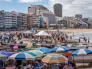
Las Palmas, officially Las Palmas de Gran Canaria, is a Spanish city and capital of Gran Canaria, in the Canary Islands, in the Atlantic Ocean.

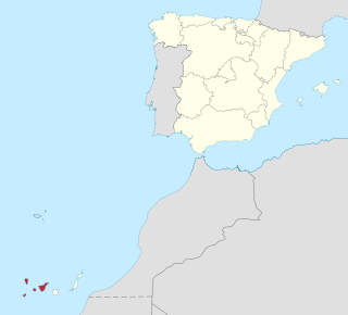
La Palma, also known as La isla bonita and historically San Miguel de La Palma, is the most northwesterly island of the Canary Islands, Spain, which is a Spanish autonomous community and archipelago in Macaronesia in the North Atlantic Ocean. La Palma has an area of 708.32 square kilometres (273.48 sq mi) making it the fifth largest of the eight main Canary Islands. The total population at the start of 2023 was 84,338, of which 15,522 lived in the capital, Santa Cruz de La Palma and 20,375 in Los Llanos de Aridane. Its highest mountain is the Roque de los Muchachos, at 2,426 metres (7,959 ft), being second among the peaks of the Canaries after the Teide massif on Tenerife.

Santa Cruz de Tenerife, commonly abbreviated as Santa Cruz, is a city, the capital of the island of Tenerife, Province of Santa Cruz de Tenerife, and one of the capitals of the Canary Islands, along with Las Palmas. Santa Cruz has a population of 206,593 (2013) within its administrative limits. The urban zone of Santa Cruz extends beyond the city limits with a population of 507,306 and 538,000 within urban area. It is the second largest city in the Canary Islands and the main city on the island of Tenerife, with nearly half of the island's population living in or around it.
Los Realejos is a town and a municipality in the northern part of the island of Tenerife, which is the biggest town in the Canary Islands. It is part of the province of Santa Cruz de Tenerife, Spain. The town is located 2 km (1.2 mi) from the north coast, 5 km (3.1 mi) southwest of Puerto de la Cruz, 6 km (3.7 mi) west of La Orotava, and 34 km (21 mi) southwest of the island's capital Santa Cruz de Tenerife. The inhabitants are known in Spanish as realejeros.

Garafía is a municipality in the island of La Palma, Santa Cruz de Tenerife. Located in the northwest of the island, in the middle of two whims of nature: the ravines of Franceses bordering Barlovento and Izcagua by the South, bordering Punta Gorda. The administrative capital, home to the City Council, is called Santo Domingo; its parish church, Iglesia de Nuestra Señora de La Luz dates back to the 16th century. Garafía has a length of 25.50 km coastline.

Adeje is a town and municipality in the southwestern part of the island of Tenerife, one of the Canary Islands, and part of the province of Santa Cruz de Tenerife, Spain. The town Adeje is located 4 km from the coast, 8 km north of the resort town Los Cristianos, 60 km southwest of the island capital Santa Cruz de Tenerife and about 17 km northwest of Tenerife South Airport.

Santa Cruz de la Palma is a city and a municipality on the east coast of the island of La Palma in the province of Santa Cruz de Tenerife of the Canary Islands. Santa Cruz de la Palma is the second-largest city and is the capital of the island. It is along an old lava flow coming from the Caldereta, a volcano just south of the city. Santa Cruz de La Palma has the privilege of having the first democratically elected town hall in Spain.

San Andrés y Sauces is a municipality on the island of La Palma, Province of Santa Cruz de Tenerife, Canary Islands, Spain. It is situated in the northeastern part of the island. The population of the municipality is 4,473 (2013) and the area is 42.75 km². The elevation of the largest village Los Sauces is 250 m. Los Sauces is 14 km north of the island capital Santa Cruz de La Palma. The municipality takes its name from the villages Los Sauces and San Andrés, 1.5 km southeast of Los Sauces, at the coast.

Tijarafe is a town and a municipality on the island of La Palma, Province of Santa Cruz de Tenerife, Canary Islands, Spain. It is situated in the northwestern part of the island. The population of the municipality is 2,776 (2013) and the area is 53.76 km². Tijarafe is 7 km northwest of Los Llanos de Aridane and 19 km west of the island capital Santa Cruz de La Palma.
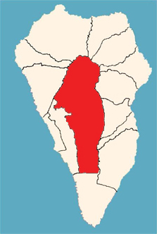
El Paso, also known as Ciudad de El Paso, is a Spanish municipality located on the island of La Palma, province of Santa Cruz de Tenerife, Canary Islands.

Tazacorte is a town and a municipality on the island of La Palma, Province of Tenerife, Canary Islands, Spain. It is near the coast, in the western part of the island. The population of the municipality is 4,600 (2018) and the area is 11.37 km2. The average elevation is 60 m. Tazacorte is 2 km southwest of Los Llanos de Aridane and 17 km west of the island capital Santa Cruz de La Palma. The inhabitants are known as Bagañetes.

La Palma is a Spanish Denominación de Origen Protegida (DOP) for wines that covers the entire island of La Palma, in the Canary Islands, Spain. It acquired its DO in 1994. There are around 600 ha of vineyards registered with the DOP, planted in a strip along the coast, though the altitude can vary between 200 m and 1,500 m above sea-level. The DOP is divided into three sub-zones.

Punta Lava Lighthouse is an active 20th century Spanish lighthouse on the Canary island of La Palma. It is located in the municipality of Tazacorte, near the village of La Bombilla on the western side of the island. The larger settlement of Puerto Naos lies 2 kilometres to the south-west.

An eruption at the Cumbre Vieja volcanic ridge, comprising the southern half of the Spanish island of La Palma in the Canary Islands, took place between 19 September and 13 December 2021. It was the first volcanic eruption on the island since the eruption of Teneguía in 1971. At 85 days, it is the longest known and the most damaging volcanic eruption on La Palma since records began. The total damage caused by the volcano amounts up to 843 million euros.

Las Manchas is a locality in the municipalities of El Paso and Los Llanos de Aridane on the island of La Palma. It is an area of historical and geographical interest, especially due to the volcanic territory in which it is located, being a tourist and cultural focus of the two municipalities. At the end of the 15th century, this area was part of the aboriginal cantons of Tihuya and Tamanca.

The Church of Saint Pius X was a Catholic church located in Todoque, Los Llanos de Aridane, La Palma. Built in 1954 and destroyed during the 2021 Cumbre Vieja volcanic eruption, it was the world's first church dedicated to Pope Pius X.

Todoque is a ghost town belonging to the municipality of Los Llanos de Aridane, located in the southwest of the island of La Palma, Canary Islands. Its main neighborhoods were Todoque, Los Pasitos and Todoque de Arriba. The town was first badly damaged and many buildings destroyed by the Cumbre Vieja vulcano eruption in September 2021, which ended up engulfing it entirely.

Los Campitos is a neighborhood of Todoque in La Palma, Canary Islands, Spain. Formerly it was a separate locality, integrated into Todoque in 2000. It was destroyed by a lava flow from the 2021 Cumbre Vieja volcanic eruption, which destroyed hundreds of houses in the neighborhood and ended up engulfing it entirely.


