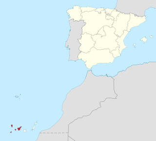
Province of Santa Cruz de Tenerife, also Province of Santa Cruz, is a province of Spain, consisting of the western part of the autonomous community of the Canary Islands. It consists of about half of the Atlantic archipelago: the islands of Tenerife, La Gomera, El Hierro, and La Palma. It occupies an area of 3,381 km2 (1,305 sq mi). It also includes a series of adjacent roques.

Santa Cruz de Tenerife, commonly abbreviated as Santa Cruz, is a city, the capital of the island of Tenerife, Province of Santa Cruz de Tenerife, and one of the capitals of the Canary Islands, along with Las Palmas. Santa Cruz has a population of 206,593 (2013) within its administrative limits. The urban zone of Santa Cruz extends beyond the city limits with a population of 507,306 and 538,000 within urban area. It is the second largest city in the Canary Islands and the main city on the island of Tenerife, with nearly half of the island's population living in or around it.
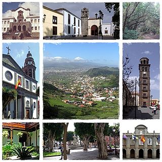
Los Realejos is a town and a municipality in the northern part of the island of Tenerife, which is the biggest town in the Canary Islands. It is part of the province of Santa Cruz de Tenerife, Spain. The town is located 2 km (1.2 mi) from the north coast, 5 km (3.1 mi) southwest of Puerto de la Cruz, 6 km (3.7 mi) west of La Orotava, and 34 km (21 mi) southwest of the island's capital Santa Cruz de Tenerife. The inhabitants are known in Spanish as realejeros.

Arona is a municipality in the southern part of the island of Tenerife in the Canary Islands, Spanish region and archipelago in the Atlantic Ocean, in Macaronesia. The municipality covers an area of 81.79 square kilometres comprising 4% of the island's area. The town of Arona is 59 km southwest of Santa Cruz de Tenerife, the island's capital. The population in 2017 was about 93,496. It is the third largest city in Tenerife, after, Santa Cruz de Tenerife and San Cristóbal de La Laguna. Arona has a pleasant climate with temperatures ranging from 20 to 25 degrees Celsius. Notable places include the tourist resorts of Los Cristianos, Playa de las Americas, Costa del Silencio and Las Galletas. Arona also features Punta Salemas, the southernmost point of the island of Tenerife. The TF-1 motorway passes through the municipality.

Garafía is a municipality in the island of La Palma, Santa Cruz de Tenerife. Located in the northwest of the island, in the middle od two whims of nature: the ravines of Franceses bordering Barlovento and Izcagua by the South, bordering Punta Gorda. The administrative capital, home to the City Council, is called Santo Domingo and has a length of 25.50 km coastline. with cliffs of incredible beauty but very steep and difficult to access, which can only be reached on foot, demanding a great effort to those not used to walking on rough terrain. Yes, their landscapes not leave anyone indifferent by the canopy of deep green vegetation that tupe those cliffs and see the ravines in contrast to the blue of the sky and its wild seas, as an example cited the gorgeous Beach Bujarén in Santo Domingo, with its roques; is the North of La Palma: a magical, unique, and unparalleled place.
San Cristóbal de La Laguna is a city and municipality in the northern part of the island of Tenerife in the Province of Santa Cruz de Tenerife, on the Canary Islands, Spain. The former capital of the Canary Islands, the city is the third-most populous city of the archipelago and the second-most populous city of the island. La Laguna's historical center was declared a World Heritage Site by UNESCO in 1999. La Laguna is situated alongside the city of Santa Cruz de Tenerife; thus, the two cities and municipalities form a single large urban center. Its economy is business-oriented while agriculture dominates the northeastern portion of the city. The urban area dominates the central and the southern parts.

Adeje is a town and municipality in the southwestern part of the island of Tenerife, one of the Canary Islands, and part of the province of Santa Cruz de Tenerife, Spain. The town Adeje is located 4 km from the coast, 8 km north of the resort town Los Cristianos, 60 km southwest of the island capital Santa Cruz de Tenerife and about 17 km northwest of Tenerife South Airport.

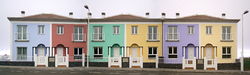
La Matanza de Acentejo is a town near the north coast of Tenerife, Canary Islands, Spain. It is located 10 km east of Puerto de la Cruz, and about 20 km west of the island's capital, Santa Cruz de Tenerife. Its name means "the Slaughter of Acentejo" in Spanish, and refers to the 1494 First Battle of Acentejo, lost by the Spanish.
Alajeró is a municipality on the island of La Gomera in the province of Santa Cruz de Tenerife in the Canary Islands. It is located on the south coast, SW of the capital San Sebastián de la Gomera. As well as being a municipality, Alajeró is also the name of the administrative town that governs that municipality.

Villa de Mazo is a town and a municipality on the island of La Palma, Province of Santa Cruz de Tenerife, Canary Islands, Spain. It is situated in the southeastern part of the island. The population of the municipality is 4,858 (2013) and the area is 71.17 km². Villa de Mazo is 9 km south of the island capital Santa Cruz de La Palma. La Palma Airport is located on the coast of Villa de Mazo.
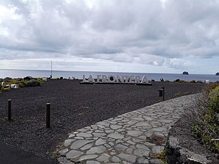
La Frontera is a municipality in the northwestern part of the island El Hierro, Santa Cruz de Tenerife, Canary Islands, Spain. In 2007, the southern part of the territory of La Frontera was split off to form the new municipality of El Pinar.

The Punta de Anaga Lighthouse is an active lighthouse on the Canary island of Tenerife, in the municipality of Santa Cruz de Tenerife. Punta de Anaga is the most northerly point on the island, and is where the Anaga mountain range meets the sea.

Punta Cumplida Lighthouse is an active 19th century Spanish lighthouse on the Canary island of La Palma in the municipality of Barlovento. Punta Cumplida is the oldest of the four main lighthouses on La Palma, each one being located near to a different cardinal point of the island. Punta Cumplida marks the north-eastern tip; Fuencaliente the southern point, and the two modern lighthouses at Punta Lava and Arenas Blancas, the eastern and western points respectively.
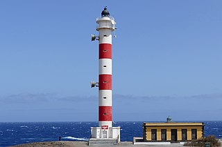
The Punta Abona Lighthouse is an active lighthouse on the south-eastern coast of Tenerife in the Canary islands. It is located between Abades and Poris de Abona, in the municipality of Arico. The lighthouse was the second to be constructed on the rocky headland of Punta Abona, which marks the south-east side of the island, and lies between the Punta de Anaga Lighthouse to the north and the Punta Rasca Lighthouse of Arona to the south.

The Punta Rasca Lighthouse is an active lighthouse in the municipality of Arona on the Canary Island of Tenerife. The current lighthouse was the second to be constructed on the headland of Punta Rasca, which is located close to the most southerly point on the island at Punta Salemas. It lies between the Punta Abona Lighthouse to the northeast and the Punta de Teno Lighthouse of Buenavista del Norte to the northwest.

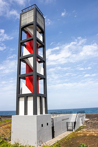
The Punta de Teno Lighthouse is an active lighthouse in the municipality of Buenavista del Norte on the Canary Island of Tenerife. The current lighthouse was the second to be constructed on the narrow rocky headland of Punta de Teno, which is the most westerly point on the island. It is one of seven lighthouses which mark the coastline of Tenerife, and lies between the Punta Rasca Lighthouse to the southeast, and the modern lighthouse of Buenavista to the northeast.
The Puerto de la Cruz Lighthouse is an active lighthouse in Puerto de la Cruz on the northern coast of Tenerife in the Canary Islands. This modern lighthouse is situated within a seafront car park, to the west of the small port in the town. It is one of seven lighthouses which mark the coastline of Tenerife, and lies between two other modern lighthouses of Punta del Hidalgo to the northeast, and Buenavista to the west.

The Punta del Hidalgo Lighthouse is an active lighthouse in Punta del Hidalgo within the municipality of San Cristóbal de La Laguna on the northeast coast of Tenerife in the Canary Islands.

The Buenavista Lighthouse, also known as the Punta de Buenavista lighthouse is an active lighthouse in the municipality of Buenavista del Norte on the northern coast of Tenerife in the Canary Islands.