Valverde, Santa Cruz de Tenerife

Last updated
Valverde
Valverde2009.jpg
Coat of Arms of Valverde (Santa Cruz de Tenerife Province).svg
Karte Gemeinde Valverde 2022.png
Location of the municipality within El Hierro
Valverde, Santa Cruz de Tenerife
Location of Valverde
Canarias-loc.svg
Red pog.svg
Valverde
Espana-Canarias-loc.svg
Red pog.svg
Valverde
Coordinates: 27°48′0″N17°55′0″W / 27.80000°N 17.91667°W / 27.80000; -17.91667
CountryFlag of Spain.svg Spain
Autonomous community Flag of the Canary Islands.svg Canary Islands
Province Provincia de Santa Cruz de Tenerife - Escudo.svg Santa Cruz de Tenerife
IslandFlag of El Hierro.svg El Hierro
Area
[1]
  Total
103.65 km2 (40.02 sq mi)
Elevation
[1]
571 m (1,873 ft)
Population
 (2024) [2]
  Total
5,268
  Density51/km2 (130/sq mi)
Postal code
E-38900

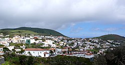
Valverde (Spanish meaning "green valley") is a municipality in the Canary Islands in the province of Santa Cruz de Tenerife. It is located on the northeast part of El Hierro (the rest of the island being the municipalities of Frontera and El Pinar). The town of the same name serves as the island's official capital. It is both the smallest Canarian capital and the only one not located by the sea. The town's airport and seaport are both several kilometres away on the island's east coast.

Contents

Pastureland and smallholdings dominate the central plateau area with pine and cloud forest at progressively higher elevations. The coastal areas and lower slopes are arid and mainly left to unimproved scrub and sparse grassland. Volcanism is prominent, with several cinder cones and areas of lava flow to be seen.

Historical population

YearPopulation
20014,227
20024,643
20034,727
20135,048
Church of Nuestra Senora de la Concepcion, Valverde Concepcionvalverde2009.JPG
Church of Nuestra Señora de la Concepción, Valverde
Charco Azul, Valverde Charco Azul.JPG
Charco Azul, Valverde
The Giant Lizard of El Hierro, endemic to this island Gallotia simonyi.jpg
The Giant Lizard of El Hierro, endemic to this island

Climate

The city has a tropical desert climate (Köppen climate classification BWh) with mild temperatures year round. [3] Winters are mild and warm with a January mean of 18.8 °C (65.8 °F). Temperatures rarely go below 10 °C (50.0 °F) with the record low being 8.0 °C (46.4 °F) on January 16, 1981. [4] Frosts are non-existent. [5] Most of the precipitation falls during the winter months. Summers are warm with the warmest month, September averaging 24.1 °C (75.4 °F), indicating a seasonal lag. Precipitation is scarce during this time, averaging 0 millimetres (0 in) to 2 millimetres (0 in). Owing to its proximity to the sea, extreme temperatures are rare with the highest temperature recorded being 34.2 °C (93.6 °F) on October 16, 1983. [4]

Valverde is at an altitude of 571 metres above sea level, while El Hierro airport is just 32 metres above sea level. The difference in altitude can have a significant effect on the weather.

Climate data for Hierro Airport
MonthJanFebMarAprMayJunJulAugSepOctNovDecYear
Record high °C (°F)28.5
(83.3)
29.4
(84.9)
32.6
(90.7)
33.2
(91.8)
31.4
(88.5)
32.0
(89.6)
32.4
(90.3)
33.8
(92.8)
33.3
(91.9)
34.2
(93.6)
32.4
(90.3)
28.3
(82.9)
34.2
(93.6)
Mean daily maximum °C (°F)20.9
(69.6)
20.8
(69.4)
21.4
(70.5)
21.6
(70.9)
22.6
(72.7)
24.0
(75.2)
25.0
(77.0)
26.1
(79.0)
26.5
(79.7)
25.6
(78.1)
23.7
(74.7)
22.2
(72.0)
23.4
(74.1)
Daily mean °C (°F)18.8
(65.8)
18.6
(65.5)
19.0
(66.2)
19.3
(66.7)
20.3
(68.5)
21.7
(71.1)
22.8
(73.0)
23.7
(74.7)
24.1
(75.4)
23.3
(73.9)
21.6
(70.9)
20.0
(68.0)
21.1
(70.0)
Mean daily minimum °C (°F)16.6
(61.9)
16.4
(61.5)
16.7
(62.1)
17.0
(62.6)
17.9
(64.2)
19.3
(66.7)
20.5
(68.9)
21.3
(70.3)
21.7
(71.1)
20.9
(69.6)
19.5
(67.1)
17.8
(64.0)
18.8
(65.8)
Record low °C (°F)8.0
(46.4)
9.0
(48.2)
9.2
(48.6)
10.0
(50.0)
10.0
(50.0)
10.0
(50.0)
14.0
(57.2)
14.2
(57.6)
15.2
(59.4)
11.0
(51.8)
12.0
(53.6)
9.6
(49.3)
8.0
(46.4)
Average precipitation mm (inches)28
(1.1)
29
(1.1)
20
(0.8)
14
(0.6)
2
(0.1)
1
(0.0)
0
(0)
0
(0)
2
(0.1)
12
(0.5)
26
(1.0)
33
(1.3)
170
(6.7)
Average precipitation days (≥ 1.0 mm)32310000022419
Average relative humidity (%)74767474747577787776747475
Mean monthly sunshine hours 1401581841972332292102342101891571432,339
Source 1: Agencia Estatal de Meteorología (normals 1971-2010) [5]
Source 2: Agencia Estatal de Meteorología (extremes only 1973-present) [4]

See also

References

  1. 1 2 "SUPERFICIE, PERÍMETRO Y ALTITUD DE LOS MUNICIPIOS DE CANARIAS" (in Spanish). Instituto Canario de Estadística (ISTAC). Archived from the original on 2012-12-04.
  2. Municipal Register of Spain 2018. National Statistics Institute.
  3. Kottek, M.; J. Grieser; C. Beck; B. Rudolf; F. Rubel (2006). "World Map of the Köppen-Geiger climate classification updated" (PDF). Meteorol. Z. 15 (3): 259–263. doi:10.1127/0941-2948/2006/0130 . Retrieved January 14, 2013.
  4. 1 2 3 "Valores extremos. Hierro Aeropuerto" (in Spanish). Agencia Estatal de Meteorología. Retrieved January 14, 2013.
  5. 1 2 "Valores climatológicos normales. Hierro Aeropuerto" (in Spanish). Agencia Estatal de Meteorología. Retrieved January 14, 2013.