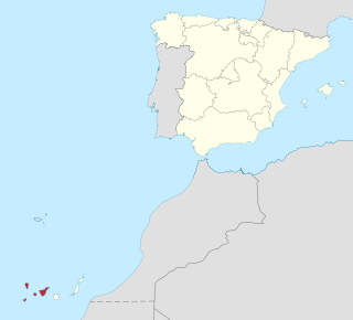
Province of Santa Cruz de Tenerife, also Province of Santa Cruz, is a province of Spain, consisting of the western part of the autonomous community of the Canary Islands. It consists of about half of the Atlantic archipelago: the islands of Tenerife, La Gomera, El Hierro, and La Palma. It occupies an area of 3,381 km2 (1,305 sq mi). It also includes a series of adjacent roques.

Tenerife is the largest and most populous island of the eight Canary Islands. It is home to 43% of the total population of the Canary Islands. With a land area of 2,034.38 square kilometres (785.48 sq mi) and a population of 917,841 inhabitants at the start of 2019 it is also the most populous island of Spain and of Macaronesia.

La Palma, also San Miguel de La Palma, is the most north-westerly island of the Canary Islands, Spain. La Palma has an area of 708 square kilometres (273 sq mi) making it the fifth largest of the seven main Canary Islands. The total population at the start of 2019 was 82,671, of which 15,716 lived in the capital, Santa Cruz de la Palma and about 20,467 in Los Llanos de Aridane. La Palma has "sister city" status with El Dorado Hills, California. Its highest mountain is the Roque de los Muchachos, at 2,423 metres (7,949 ft), being second among the peaks of the Canaries only to the peaks of the Teide massif on Tenerife.

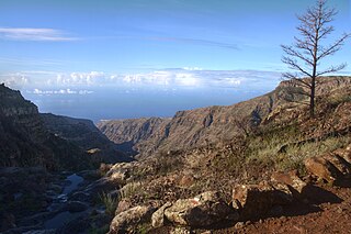
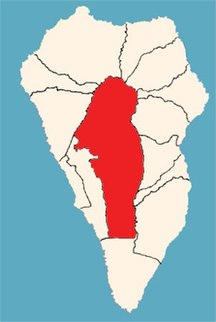
Barlovento is a municipality in the northern part of the island of La Palma, one of the Canary Islands, and a part of the province of Santa Cruz de Tenerife. Barlovento is on the main highway which encircles the island. The land rises steeply from a small coastal plain, to the rim of the Caldera de Taburiente at Pico de la Cruz (2,350m)

Pájara is a municipality in the southwestern portion of the island of Fuerteventura in the Province of Las Palmas in the Canary Islands as well as the name of its largest town. Its population is 20,931 (2013), and the area is 383.52 km². Pájara is both the southernmost and the westernmost municipality on the island. Pájara is also the largest municipality on the island. The largest towns in the municipality of Pájara are Morro Jable and Costa Calma, both situated on the coast. The small port Ajuy is situated in the north of the municipality, near Betancuria. The Jandía peninsula is part of the municipality.

Santa Brígida is a town and a municipality in the northeastern part of the island of Gran Canaria in the Province of Las Palmas of the Canary Islands. Its population is 18,791 (2013), and the area is 23.81 km². It is situated in the mountains, 13 km southwest of Las Palmas.

Santiago del Teide is a town and a municipality in the western part of the island Tenerife, Canary Islands, and part of the province of Santa Cruz de Tenerife. The area of the municipality is 52.21 km², the population is 12,634 (2013). Beach resort towns in the municipality are Los Gigantes, Puerto de Santiago and Playa de la Arena. The steep cliffs Acantilados de Los Gigantes are situated on the coast of the municipality.

La Guancha is a municipality in the northern part of the island of Tenerife, one of the Canary Islands, and part of the province of Santa Cruz de Tenerife. It is located about 40 km west of the island's capital Santa Cruz de Tenerife, and 6 km east of Icod de los Vinos. The population is 5,448 (2013) and the area is 23.77 km². The elevation is 501 m.
Vallehermoso is a village and municipality in the western part of the island La Gomera in the province of Santa Cruz de Tenerife of the Canary Islands, Spain. The town of Vallehermoso, the seat of the municipality, is situated in the northern part of the municipality, 3 km from the coast and 18 km northwest of the island capital, San Sebastián de la Gomera.

Villa de Mazo is a town and a municipality on the island of La Palma, Province of Santa Cruz de Tenerife, Canary Islands, Spain. It is situated in the southeastern part of the island. The population of the municipality is 4,858 (2013) and the area is 71.17 km². Villa de Mazo is 9 km south of the island capital Santa Cruz de La Palma. La Palma Airport is located on the coast of Villa de Mazo.

Breña Baja is a municipality on the eastern side of the island of La Palma, in the province of Santa Cruz de Tenerife, in the Canary Islands. The ayuntamiento is in the town of San José with an elevation of 300 m. Until the 17th century the area was known as Breña, but was then divided into Breña Alta and Breña Baja.

Breña Alta is a municipality on the eastern side of the island of La Palma, in the province of Santa Cruz de Tenerife, in the Canary Islands. The ayuntamiento is in the town of San Pedro, at 350 m above sea-level, and only 9 km south of the island's capital Santa Cruz de la Palma. Breña Alta lies on the main highway encircling the island, just north of La Palma Airport. Until the 17th century the area was known as Breña, but was then divided into Breña Alta and Breña Baja.

Santa Cruz de la Palma is a city and a municipality on the east coast of the island of La Palma in the province of Santa Cruz de Tenerife of the Canary Islands. Santa Cruz de la Palma is the second-largest city and is the capital of the island. It is along an old lava flow coming from the Caldereta, a volcano just south of the city.

Puntallana is a town and a municipality on the island of La Palma, Province of Santa Cruz de Tenerife, Canary Islands, Spain. It is situated in the northeastern part of the island. The population of the municipality is 2,346 (2013) and the area is 35.10 km². The elevation is 420 m. Puntallana is 7 km northeast of the island capital Santa Cruz de La Palma.

San Andrés y Sauces is a municipality on the island of La Palma, Province of Santa Cruz de Tenerife, Canary Islands, Spain. It is situated in the northeastern part of the island. The population of the municipality is 4,473 (2013) and the area is 42.75 km². The elevation of the largest village Los Sauces is 250 m. Los Sauces is 14 km north of the island capital Santa Cruz de La Palma. The municipality takes its name from the villages Los Sauces and San Andrés, 1.5 km southeast of Los Sauces, at the coast.

Puntagorda is a village and a municipality in the northwestern part of the island of La Palma, Canary Islands, Spain. It is situated 23 km northwest of Santa Cruz de la Palma. The municipality consists of a number of small villages, total population 2,057 (2013). The area is 31.10 km². The elevation of the village is around 700 m. The elevation of the municipality ranges from sea level to over 2000 m.

Tijarafe is a town and a municipality on the island of La Palma, Province of Santa Cruz de Tenerife, Canary Islands, Spain. It is situated in the northwestern part of the island. The population of the municipality is 2,776 (2013) and the area is 53.76 km². Tijarafe is 7 km northwest of Los Llanos de Aridane and 19 km west of the island capital Santa Cruz de La Palma.
El Paso, also known as Ciudad de El Paso, is a Spanish municipality located on the island of La Palma, province of Santa Cruz de Tenerife, Canary Islands.

Punta Cumplida Lighthouse is an active 19th century Spanish lighthouse on the Canary island of La Palma in the municipality of Barlovento. Punta Cumplida is the oldest of the four main lighthouses on La Palma, each one being located near to a different cardinal point of the island. Punta Cumplida marks the north-eastern tip; Fuencaliente the southern point, and the two modern lighthouses at Punta Lava and Arenas Blancas, the eastern and western points respectively.

Punta Lava Lighthouse is an active 20th century Spanish lighthouse on the Canary island of La Palma. It is located in the municipality of Tazacorte, near the village of La Bombilla on the western side of the island. The larger settlement of Puerto Naos lies 2 kilometres to the south-west.