Mérida is a city and municipality of Spain, part of the Province of Badajoz, and capital of the autonomous community of Extremadura. Located in the western-central part of the Iberian Peninsula at 217 metres above sea level, the city is crossed by the Guadiana and Albarregas rivers. The population was 60,119 in 2017.

Tenerife is the largest and most populous island of the Canary Islands. It is home to 42.9% of the total population of the archipelago. With a land area of 2,034.38 square kilometres (785.48 sq mi) and a population of 948,815 inhabitants as of January 2023, it is also the most populous island of Spain and of Macaronesia.

Santa Cruz de Tenerife, commonly abbreviated as Santa Cruz, is a city, the capital of the island of Tenerife, Province of Santa Cruz de Tenerife, and one of the capitals of the Canary Islands, along with Las Palmas. Santa Cruz has a population of 206,593 (2013) within its administrative limits. The urban zone of Santa Cruz extends beyond the city limits with a population of 507,306 and 538,000 within urban area. It is the second largest city in the Canary Islands and the main city on the island of Tenerife, with nearly half of the island's population living in or around it.

Roque de los Muchachos Observatory is an astronomical observatory located in the municipality of Garafía on the island of La Palma in the Canary Islands, Spain. The observatory site is operated by the Instituto de Astrofísica de Canarias, based on nearby Tenerife. ORM is part of the European Northern Observatory.

Yaiza is a small town in the island of Lanzarote in the Canary Islands, Spain. It lies in the southwest of the island. The population in 2012 was 857. The town gives its name to the municipality of Yaiza, although it is much smaller than the largest settlement in the municipality, Playa Blanca.

Vega de San Mateo is a town and a municipality in the mountainous central part of the island of Gran Canaria in the Province of Las Palmas in the Canary Islands. Its population is 7,774 (2013), and the area is 37.89 km2. Vega de San Mateo is located 17 km southwest of Las Palmas.

Güímar is the name of a municipality, town and valley in the eastern part of the Spanish island of Tenerife, one of the Canary Islands, and part of Santa Cruz de Tenerife (province). The municipality extends for 102.9 square kilometers from the mountainous interior to the beaches on the Atlantic, and borders the municipalities of La Orotava, Arafo and Fasnia. Its estimated population is 18,589 (2013). The TF-1 motorway passes through the municipality.

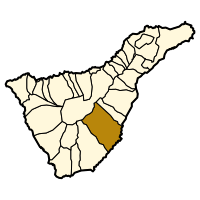
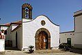
San Miguel de Abona is a town and a municipality in the southern part of the island of Tenerife, one of the Canary Islands, and part of the province of Santa Cruz de Tenerife, Spain. The TF-1 motorway passes through the southern part of the municipality.

Vilaflor is a municipality and village in the south-central part of the island of Tenerife, one of the Canary Islands, and part of Santa Cruz de Tenerife (province), Spain. Vilaflor, with an altitude of 1,400 m, is the highest village on Tenerife, situated south of the Teide volcano. It is located 7 km north of San Miguel de Abona and 51 km southwest of the island's capital Santa Cruz de Tenerife. The population is 1,645 (2018) and the area is 56.26 km².

Adeje is a town and municipality in the southwestern part of the island of Tenerife, one of the Canary Islands, and part of the province of Santa Cruz de Tenerife, Spain. The town Adeje is located 4 km from the coast, 8 km north of the resort town Los Cristianos, 60 km southwest of the island capital Santa Cruz de Tenerife and about 17 km northwest of Tenerife South Airport.
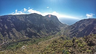
Valle Gran Rey is a municipality in the western part of the island La Gomera, in the province of Santa Cruz de Tenerife of the Canary Islands, Spain. The Guanche name of the area was Orone. The seat of the municipality since 1930 is La Calera; previously it was in Arure.
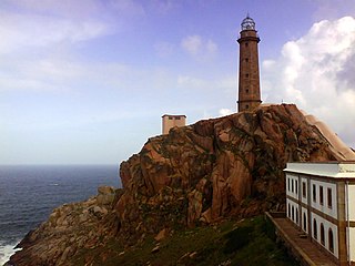
Camariñas is a municipality in the province of A Coruña in the autonomous community of Galicia in northwestern Spain. It belongs to the comarca of Terra de Soneira. An important fishing center, it is renowned all over Spain by the bobbin lace work of its women.

Montoro is a municipality of Spain belonging to the province of Córdoba, Andalusia. Housing lies on a bend of the river Guadalquivir, which envelopes from West, North, and East.

The Alfabia Mountains are a mountain range in Majorca located in the municipality of Fornalutx.

The TF-1 is a motorway encircling the eastern and the southern parts of the island of Tenerife. The TF-1 motorway runs from the capital Santa Cruz in the north to Adeje with its major tourist resorts Los Cristianos and Playa de las Américas in the south of the island, and continues to Santiago del Teide in the west. It is a 103 km motorway and interchange numbers go facing south. The motorway is one in the Canary Islands that passes through most of the municipalities and is the longest in the archipelago.

Abades “on Tenerife” is a small holiday resort located on the southeast coast of Tenerife, the largest of Spain’s Canary Islands, in the municipality of Arico, between Poris de Abona and La Jaca.

The climate of Spain is highly diverse and varies considerably across the country's various regions. In fact, Spain is sometimes described as the most climatically diverse country in Europe and has 13 different Köppen, climates.

Adjona, also written Adxoña or Atxoña was the Guanche mencey (king) of the Menceyato de Abona at the time of the conquest of Tenerife in the fifteenth century.
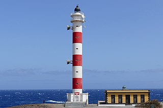
The Punta Abona Lighthouse is an active lighthouse on the south-eastern coast of Tenerife in the Canary islands. It is located between Abades and Poris de Abona, in the municipality of Arico. The lighthouse was the second to be constructed on the rocky headland of Punta Abona, which marks the south-east side of the island, and lies between the Punta de Anaga Lighthouse to the north and the Punta Rasca Lighthouse of Arona to the south.