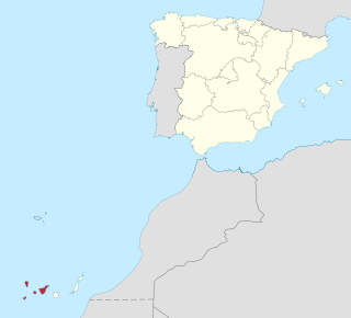
Province of Santa Cruz de Tenerife, also Province of Santa Cruz, is a province of Spain, consisting of the western part of the autonomous community of the Canary Islands. It consists of about half of the Atlantic archipelago: the islands of Tenerife, La Gomera, El Hierro, and La Palma. It occupies an area of 3,381 km2 (1,305 sq mi). It also includes a series of adjacent roques.

The Guanche were the indigenous inhabitants of the Spanish Canary Islands, located in the Atlantic Ocean some 100 kilometres (60 mi) to the west of modern Morocco and the North African coast. The islanders spoke the Guanche language, which is believed to have been related to the Berber languages of mainland North Africa; the language became extinct in the 17th century, soon after the islands were colonized.
Tenerife is the largest and most populous island of the Canary Islands. It is home to 42.9% of the total population of the archipelago. With a land area of 2,034.38 square kilometres (785.48 sq mi) and a population of 948,815 inhabitants as of January 2023, it is also the most populous island of Spain and of Macaronesia.

Santa Cruz de Tenerife, commonly abbreviated as Santa Cruz, is a city, the capital of the island of Tenerife, Province of Santa Cruz de Tenerife, and one of the capitals of the Canary Islands, along with Las Palmas. Santa Cruz has a population of 206,593 (2013) within its administrative limits. The urban zone of Santa Cruz extends beyond the city limits with a population of 507,306 and 538,000 within urban area. It is the second largest city in the Canary Islands and the main city on the island of Tenerife, with nearly half of the island's population living in or around it.
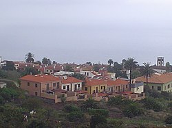
Los Realejos is a town and a municipality in the northern part of the island of Tenerife, which is the biggest town in the Canary Islands. It is part of the province of Santa Cruz de Tenerife, Spain. The town is located 2 km (1.2 mi) from the north coast, 5 km (3.1 mi) southwest of Puerto de la Cruz, 6 km (3.7 mi) west of La Orotava, and 34 km (21 mi) southwest of the island's capital Santa Cruz de Tenerife. The inhabitants are known in Spanish as realejeros.

The First Battle of Acentejo took place on the island of Tenerife between the Guanches and an alliance of Spaniards, other Europeans, and associated natives, on 31 May 1494, during the Spanish conquest of this island. It resulted in a victory for the Guanches of Tenerife.
Tegueste is a town and a municipality of the northeastern part of the island of Tenerife in the Santa Cruz de Tenerife province, on the Canary Islands, Spain. It is surrounded by the municipality of San Cristóbal de La Laguna. The town Tegueste is located 4 km northwest of San Cristóbal de La Laguna and 11 km northwest of the island capital Santa Cruz de Tenerife. Tegueste became independent from San Cristóbal de La Laguna in the 17th century.

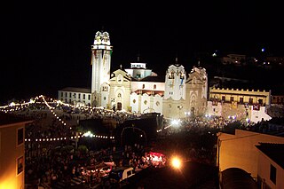
Candelaria, also Villa Mariana de Candelaria, is a municipality and city in the eastern part of the island of Tenerife in the Province of Santa Cruz de Tenerife, in the Canary Islands, Spain. The city is located on the coast, 17 km southwest of Santa Cruz de Tenerife. The population is 25,140 (2010), and the area is 49.18 km².

Vilaflor is a municipality and village in the south-central part of the island of Tenerife, one of the Canary Islands, and part of Santa Cruz de Tenerife (province), Spain. Vilaflor, with an altitude of 1,400 m, is the highest village on Tenerife, situated south of the Teide volcano. It is located 7 km north of San Miguel de Abona and 51 km southwest of the island's capital Santa Cruz de Tenerife. The population is 1,645 (2018) and the area is 56.26 km².

Adeje is a town and municipality in the southwestern part of the island of Tenerife, one of the Canary Islands, and part of the province of Santa Cruz de Tenerife, Spain. The town Adeje is located 4 km from the coast, 8 km north of the resort town Los Cristianos, 60 km southwest of the island capital Santa Cruz de Tenerife and about 17 km northwest of Tenerife South Airport.

La Orotava is a town and a municipality in the northern part of Tenerife, one of the Canary Islands of Spain. The area of the municipality stretches from the north coast to the mountainous interior, and includes the summit of the Teide volcano, Canary Islands' and Spain's highest point at 3,718 m. At 207.31 km2, it is the largest municipality of the island of Tenerife. The population is 41,255 (2013).

La Matanza de Acentejo is a town near the north coast of Tenerife, Canary Islands, Spain. It is located 10 km east of Puerto de la Cruz, and about 20 km west of the island's capital, Santa Cruz de Tenerife. Its name means "the Slaughter of Acentejo" in Spanish, and refers to the 1494 First Battle of Acentejo, lost by the Spanish.

Hermigua is a town and a municipality in the northeastern part of La Gomera in the province of Santa Cruz de Tenerife of the Canary Islands, Spain. It is located 12 km northwest of the island's capital, San Sebastián de la Gomera. The Garajonay National Park covers the southern part of the municipality.

Fuencaliente de La Palma, also Fuencaliente, is a municipality in the southern part of the island La Palma in the province of Santa Cruz de Tenerife of the Canary Islands, Spain. The seat of the municipality is the village Los Canarios. It has been the seat since 1837. The population of the municipality is 1,798 (2013) and the area is 56.42 km².

Tijarafe is a town and a municipality on the island of La Palma, Province of Santa Cruz de Tenerife, Canary Islands, Spain. It is situated in the northwestern part of the island. The population of the municipality is 2,776 (2013) and the area is 53.76 km². Tijarafe is 7 km northwest of Los Llanos de Aridane and 19 km west of the island capital Santa Cruz de La Palma.

San Andrés is a village located on the island of Tenerife in the Canary Islands (Spain). It is located on the coast, at the foot of the Anaga mountains, 7 km (4.3 mi) northeast of the capital city Santa Cruz de Tenerife. It is administratively part of the municipality of Santa Cruz de Tenerife. San Andrés is one of the oldest villages of Canary Islands, and was founded around 1498.
The Battle of Aguere, or Battle of San Cristóbal de La Laguna, was fought between forces of the Crown of Castile, led by the Adelantado Alonso Fernández de Lugo, and the natives of Tenerife, called Guanches. The battle took place on 14-15 November 1494.

Alternativa Popular Canaria is a Canarian nationalist leftist party founded in 2002, and part of the Movimiento de Liberación Nacional Canario (MLNC). Its creation was spurred by the youth organisation Azarug and several municipal parties, as well as members of various leftist nationalist parties.

The Guanche mummies of Necochea are two mummies of Guanche individuals, who were the ancient Berber autochthones of the Canary Islands. The specimens are currently on display at the Museo de la Naturaleza y el Hombre in Santa Cruz de Tenerife.
The pilgrimage to Candelaria is a religious march that takes place every year on the night of August 14 to 15 in Tenerife towards the municipality of Candelaria where the image is located. of the Patroness of the Canary Islands, the Virgin of Candelaria. It is one of the most popular events in the Canary Islands.