Valle Gran Rey | |
---|---|
Coordinates: 28°6′N17°20′W / 28.100°N 17.333°W | |
Country | Spain |
Autonomous Region | Canary Islands |
Province | Santa Cruz de Tenerife |
Island | La Gomera |
Government | |
• Mayor | Angel Piñero Cruz |
Area | |
• Total | 32.36 km2 (12.49 sq mi) |
Population (2018) [2] | |
• Total | 4,484 |
• Density | 140/km2 (360/sq mi) |
Time zone | UTC+0 (GMT) |
Website | www.vallegranrey.es |
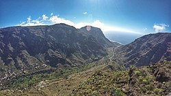
Valle Gran Rey is a municipality in the western part of the island La Gomera, in the province of Santa Cruz de Tenerife of the Canary Islands, Spain. The Guanche name of the area was Orone. [3] The seat of the municipality since 1930 is La Calera; previously it was in Arure.
The population was 4,240 in 2013, [4] and the area is 32.36 square kilometres (12.49 sq mi). [1] Valle Gran Rey borders the municipality of Vallehermoso to the east, while the Atlantic Ocean lies to the west.
It is located in the west of the island, bordering the municipality of Vallehermoso. It has an extension of 32.36 km2 (12½ sq. mi.). [5] The altitude of the municipal capital is about 50 meters (200') above sea level, reaching a maximum altitude of 1,225 meters (4020') above sea level at the central summit of the island. [6]
Valle Gran Rey has a hot-summer Mediterranean climate (Köppen: Csb; Trewartha: Csal), depending on the altitude and location of the nearest weather station in Arure, the precipitation is three to four times higher than in coastal areas due to its location on the windward slope.
Climate data for Valle Gran Rey (Arure ) Climate ID: C316I; coordinates 28°07′42″N17°18′54″W / 28.12833°N 17.31500°W ; elevation: 916 m (3,005 ft); 2018–2024 normals, extremes 2018–present [7] | |||||||||||||
---|---|---|---|---|---|---|---|---|---|---|---|---|---|
Month | Jan | Feb | Mar | Apr | May | Jun | Jul | Aug | Sep | Oct | Nov | Dec | Year |
Record high °C (°F) | 24.5 (76.1) | 26.4 (79.5) | 30.9 (87.6) | 32.4 (90.3) | 34.8 (94.6) | 36.8 (98.2) | 40.0 (104.0) | 42.1 (107.8) | 36.2 (97.2) | 36.5 (97.7) | 29.3 (84.7) | 24.9 (76.8) | 42.1 (107.8) |
Mean daily maximum °C (°F) | 15.5 (59.9) | 17.1 (62.8) | 17.0 (62.6) | 18.3 (64.9) | 20.5 (68.9) | 22.1 (71.8) | 27.5 (81.5) | 28.9 (84.0) | 25.0 (77.0) | 23.1 (73.6) | 19.3 (66.7) | 17.4 (63.3) | 21.0 (69.8) |
Daily mean °C (°F) | 12.5 (54.5) | 13.6 (56.5) | 13.6 (56.5) | 14.3 (57.7) | 16.2 (61.2) | 17.8 (64.0) | 22.2 (72.0) | 23.8 (74.8) | 20.6 (69.1) | 19.3 (66.7) | 16.0 (60.8) | 14.3 (57.7) | 17.0 (62.6) |
Mean daily minimum °C (°F) | 9.4 (48.9) | 10.1 (50.2) | 10.1 (50.2) | 10.3 (50.5) | 11.8 (53.2) | 13.5 (56.3) | 17.0 (62.6) | 18.8 (65.8) | 16.1 (61.0) | 15.4 (59.7) | 12.7 (54.9) | 11.2 (52.2) | 13.0 (55.4) |
Record low °C (°F) | 5.4 (41.7) | 4.7 (40.5) | 5.7 (42.3) | 7.3 (45.1) | 8.0 (46.4) | 9.9 (49.8) | 11.8 (53.2) | 12.6 (54.7) | 12.4 (54.3) | 9.9 (49.8) | 8.2 (46.8) | 7.8 (46.0) | 4.7 (40.5) |
Average precipitation mm (inches) | 58.6 (2.31) | 53.4 (2.10) | 50.0 (1.97) | 26.0 (1.02) | 6.6 (0.26) | 12.9 (0.51) | 1.0 (0.04) | 3.7 (0.15) | 17.1 (0.67) | 28.4 (1.12) | 55.8 (2.20) | 57.5 (2.26) | 370.8 (14.60) |
Average precipitation days (≥ 0.1 mm) | 12.00 | 9.80 | 12.00 | 6.40 | 3.60 | 4.60 | 2.20 | 1.60 | 4.33 | 9.33 | 11.17 | 11.50 | 88.53 |
Average relative humidity (%) | 71 | 63 | 74 | 75 | 68 | 71 | 49 | 45 | 66 | 68 | 73 | 71 | 66 |
Source: State Meteorological Agency/AEMET OpenData [8] [9] |
Year | Population |
---|---|
1991 | 3,103 |
1996 | 3,631 |
2001 | 4,238 |
2002 | 4,248 |
2003 | 4,487 |
2004 | 4,745 |
2005 | 4,857 |
2013 | 4,240 |
The Canary Islands, also known informally as the Canaries, are a Spanish region, autonomous community and archipelago in the Atlantic Ocean. At their closest point to the African mainland, they are 100 kilometres west of Morocco. They are the southernmost of the autonomous communities of Spain. The islands have a population of 2.2 million people and are the most populous special territory of the European Union.
Province of Santa Cruz de Tenerife, also Province of Santa Cruz, is a province of Spain, consisting of the western part of the autonomous community of the Canary Islands. It consists of about half of the Atlantic archipelago: the islands of Tenerife, La Gomera, El Hierro, and La Palma. It occupies an area of 3,381 km2 (1,305 sq mi). It also includes a series of adjacent roques.
La Gomera is one of Spain's Canary Islands, in the Atlantic Ocean off the coast of Africa. With an area of 370.03 km2 (142.87 sq mi), it is the third-smallest of the archipelago's eight main islands. It belongs to the province of Santa Cruz de Tenerife. La Gomera is the third least populous of the eight main Canary Islands, with 22,361 inhabitants at the start of 2023. Its capital is San Sebastián de La Gomera, where the cabildo insular is located.
Gran Canaria, also Grand Canary Island, is the third-largest and second-most-populous island of the Canary Islands, an archipelago off the Atlantic coast of Northwest Africa and is part of Spain. As of 2023 the island had a population of 862,893 that constitutes approximately 40% of the population of the archipelago. Las Palmas de Gran Canaria, the capital of the island, is the biggest city of the Canary Islands and the ninth of Spain.
Tenerife is the largest and most populous island of the Canary Islands. It is home to 42.9% of the total population of the archipelago. With a land area of 2,034.38 square kilometres (785.48 sq mi) and a population of 948,815 inhabitants as of January 2023, it is also the most populous island of Spain and of Macaronesia.
La Palma, also known as La isla bonita and historically San Miguel de La Palma, is the most northwesterly island of the Canary Islands, Spain, which is a Spanish autonomous community and archipelago in Macaronesia in the North Atlantic Ocean. La Palma has an area of 708.32 square kilometres (273.48 sq mi) making it the fifth largest of the eight main Canary Islands. The total population at the start of 2023 was 84,338, of whom 15,522 lived in the capital, Santa Cruz de La Palma and 20,375 in Los Llanos de Aridane. Its highest mountain is the Roque de los Muchachos, at 2,426 metres (7,959 ft), being second among the peaks of the Canaries after the Teide massif on Tenerife.
Santa Cruz de Tenerife, commonly abbreviated as Santa Cruz, is a city, the capital of the island of Tenerife, Province of Santa Cruz de Tenerife, and one of the capitals of the Canary Islands, along with Las Palmas. Santa Cruz has a population of 206,593 (2013) within its administrative limits. The urban zone of Santa Cruz extends beyond the city limits with a population of 507,306 and 538,000 within urban area. It is the second largest city in the Canary Islands and the main city on the island of Tenerife, with nearly half of the island's population living in or around it.
Roque de los Muchachos Observatory is an astronomical observatory located in the municipality of Garafía on the island of La Palma in the Canary Islands, Spain. The observatory site is operated by the Instituto de Astrofísica de Canarias, based on nearby Tenerife. ORM is part of the European Northern Observatory.
Graciosa Island or commonly La Graciosa is a volcanic island in the Canary Islands of Spain, located two kilometres north of Lanzarote across the Strait of El Río. As the rest of the Canary Islands, it was formed by the Canary hotspot. The island is part of the Chinijo Archipelago and the Chinijo Archipelago Natural Park. It is administered by the municipality of Teguise in the neighboring island of Lanzarote. In 2018 La Graciosa was officially declared the eighth Canary Island by the Spanish Senate, with few real effects. Before then, the island had the status of an islet. It's administratively dependent on the island of Lanzarote.
Vega de San Mateo is a town and a municipality in the mountainous central part of the island of Gran Canaria in the Province of Las Palmas in the Canary Islands. Its population is 7,774 (2013), and the area is 37.89 km2. Vega de San Mateo is located 17 km southwest of Las Palmas.
Tejeda is a village and a municipality in the mountainous central part of the island of Gran Canaria in the province of Las Palmas in the Canary Islands.
Adeje is a town and municipality in the southwestern part of the island of Tenerife, one of the Canary Islands, and part of the province of Santa Cruz de Tenerife, Spain. The town Adeje is located 4 km from the coast, 8 km north of the resort town Los Cristianos, 60 km southwest of the island capital Santa Cruz de Tenerife and about 17 km northwest of Tenerife South Airport.
La Guancha is a municipality in the northern part of the island of Tenerife, one of the Canary Islands, and part of the province of Santa Cruz de Tenerife. It is located about 40 km west of the island's capital Santa Cruz de Tenerife, and 6 km east of Icod de los Vinos. The population is 5,448 (2013) and the area is 23.77 km². The elevation is 501 m.
Agulo is located on the north coast of the island of La Gomera in the province of Santa Cruz de Tenerife of the Canary Islands. It is located 13 km northwest of the capital San Sebastián de la Gomera. The population was 1,100 in 2013.
Hermigua is a town and a municipality in the northeastern part of La Gomera in the province of Santa Cruz de Tenerife of the Canary Islands, Spain. It is located 12 km northwest of the island's capital, San Sebastián de la Gomera. The Garajonay National Park covers the southern part of the municipality.
San Sebastián de La Gomera is the capital and a municipality of La Gomera in the Canary Islands, Spain. It also hosts the main harbour. The population was 9,584 in 2023, and the area is 113.59 square kilometres (43.86 sq mi).
Alajeró is a municipality on the island of La Gomera in the province of Santa Cruz de Tenerife in the Canary Islands. It is located on the south coast, SW of the capital San Sebastián de la Gomera. As well as being a municipality, Alajeró is also the name of the administrative town that governs that municipality.
Vallehermoso is a village and municipality in the western part of the island La Gomera in the province of Santa Cruz de Tenerife of the Canary Islands, Spain. The town of Vallehermoso, the seat of the municipality, is situated in the northern part of the municipality, 3 km from the coast and 18 km northwest of the island capital, San Sebastián de la Gomera.
"Bajada" is the shortened version of the Fiestas de la Bajada which is a festival which takes place in several places in the Canary Islands. Bajada is Spanish for "bringing down", and means the bringing of a patron saint's statue from its normal place in a chapel to be celebrated by the people.