The transport network in Uruguay consists of 1,673 km of rail network, 7,743 km of paved roads, 1,600 km of navigable waterways, and 11 airports with paved roads.

Misiones is one of the 23 provinces of Argentina, located in the northeastern corner of the country in the Mesopotamia region. It is surrounded by Paraguay to the northwest, Brazil to the north, east and south, and Corrientes Province of Argentina to the southwest.

La Rioja is a province of Argentina located in the west of the country. The landscape of the province consist of a series of arid to semi-arid mountain ranges and agricultural valleys in between. It is in one of these valleys that the capital of the province, the city of la La Rioja, lies. Neighboring provinces are from the north clockwise Catamarca, Córdoba, San Luis and San Juan. The dinosaur Riojasaurus is named after the province.

Risaralda or "Rizaralde", is a landlocked department of Colombia. It is located in the western central region of the country and part of the Paisa Region. Its capital is Pereira.

Margarita Island is the largest island in the Venezuelan state of Nueva Esparta, situated off the northeastern coast of the country, in the Caribbean Sea. The capital city of Nueva Esparta, La Asunción, is located on the island.

Piriápolis is a city in the Maldonado Department of Uruguay. It is an important summer resort in the country, predating the larger and better known resort town of Punta del Este. Because it is mainly used as a resort, it has a relatively small permanent population for a city of its size.
Santa María Jalapa del Marqués is a small city in the Mexican state of Oaxaca. It serves as the administrative centre for the surrounding municipality (municipio) of the same name. It is part of the Tehuantepec District in the west of the Istmo Region.

Ixtapaluca is a city and a municipality in the eastern part of the State of Mexico in Mexico. It lies between the Federal District and the western border of the state of Puebla. The name Ixtapaluca means "Where the salt gets wet".
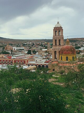
Sombrerete is a town and municipality located in the northwest of the Mexican state of Zacatecas, bordering the state of Durango.

The Purico complex is a Pleistocene volcanic complex in Chile close to Bolivia, formed by an ignimbrite, several lava domes and stratovolcanoes and one maar. It is in the Chilean segment of the Central Volcanic Zone, one of the four volcanic belts which make up the Andean Volcanic Belt. The Central Volcanic Zone spans Peru, Bolivia, Chile and Argentina and includes 44 active volcanoes as well as the Altiplano–Puna volcanic complex, a system of large calderas and ignimbrites of which Purico is a member. Licancabur to the north, La Pacana southeast and Guayaques to the east are separate volcanic systems.

San Juan Bautista Tuxtepec, or simply referred to as Tuxtepec, is the head of the municipality by the same name and is the second most populous city of the Mexican state of Oaxaca. It is part of the Tuxtepec District of the Papaloapan Region. As of the 2020 census, the city is home to a population of 103,609 and 159,452 in the municipality, though census data are often under reported for various reasons. The municipality resides in the region called La Cuenca, is located 36 feet above sea level, and occupies an area of approximately 580 square miles (1,500 km2). The city itself is surrounded by the Papaloapan River, and lies a few kilometers south of the Cerro de Oro Dam on its tributary the Santo Domingo River. The municipality is bordered by the state of Veracruz in the north, the municipalities of Loma Bonita to the east and San José Chiltepec to the south. It is almost 100 miles (160 km) to the port of Veracruz, 130 miles (210 km) to Oaxaca City, the state capital, and 310 miles (500 km) to Mexico City.

Tlaxiaco is a city, and its surrounding municipality of the same name, in the Mexican state of Oaxaca. It is located in the Tlaxiaco District in the south of the Mixteca Region, with a population of about 17,450.

Laguna del Sauce is a subtropical shallow lake and the largest water body in the Maldonado Department of Uruguay. It is located 15 kilometres (9.3 mi) west of Punta del Este. The lake is the only freshwater ecosystem in the country classified for drinking water as its principal use.
Tlatlaya is one of 125 municipalities of the State of Mexico in Mexico. The municipal seat is the town of Tlatlaya which is the eleventh largest town in the municipality. The word “Tlatlaya” means when the hearth is black and red.
Jiquipilco Municipality is one of the municipalities of the State of Mexico in Mexico. It is north of the Toluca Valley, part of the region consisting of the southern and western slopes of Cerro La Catedral, which has a concentration of speakers of the Otomi language. It is about 40 km from Toluca, the state capital. The name is a corruption of Nahuatl “Xiquipilli”, meaning “the place of saddlebags”. Jiquipilco is situated on the transversal volcanic axis that crosses Mexico in an area surrounded by lakes and volcanoes. This portion is called "Anahuac”.
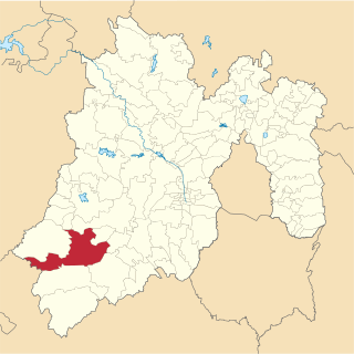
Tejupilco is a municipality in the State of Mexico, Mexico, located approximately 100 kilometres (62 mi) southwest of the state capital Toluca, along Federal Highway 134. Its municipal seat is Tejupilco de Hidalgo. The municipality has a total area of about 1,327 km2 (512 sq mi), with a contrasting topography ranging from deep ravines and canyons to high ridges; the highest elevation within the municipality reaches some 1,117 metres (3,660 ft) asl. The 2005 census recorded a population of 62,547 inhabitants.
Juan Lacaze, or Juan L. Lacaze, is a city located in southwestern Uruguay, within the Colonia Department.
Ombúes de Lavalle is a small city located in the north of Colonia Department in southwestern Uruguay. It is named after the Argentine General Juan Lavalle. The term «Ombúes» is the Spanish plural for «Ombú», a tree originary of the Pampas region, in southern South America, and a national symbol of both Argentina and Uruguay.
Cueros de Purulla is a volcano in Argentina. It consists of a lava dome and an associated ignimbrite. A large eruption dated to c. 7820 BP deposited ash into the Valles Calchaquies.

