Related Research Articles

Antofagasta de la Sierra is a volcanic field in Argentina. The main type of volcanic edifice in the area are scoria cones, it is formed by the La Laguna, Jote and Alumbrera volcanoes. The first and last of these form a sub-group which is better researched. Various dating methods have yielded ages from several million to several hundred thousand years ago, but some vents appear to be of Holocene age.

Payún Matrú is a shield volcano in the Reserva Provincial La Payunia of the Malargüe Department, south of the Mendoza Province in Argentina. It lies in the back-arc region of the Andean Volcanic Belt, and was formed by the subduction of the Nazca Plate beneath the South American Plate. Payún Matrú, along with the Llancanelo, Nevado and Salado Basin volcanic fields, form the Payenia province. It has been proposed as a World Heritage Site since 2011.

Villarrica is one of Chile's most active volcanoes, rising above the lake and town of the same name, 750 km (470 mi) south of Santiago. It is also known as Rucapillán, a Mapuche word meaning "great spirit's house" or " the demon's house". It is the westernmost of three large stratovolcanoes that trend northwest to southeast obliquely perpendicular to the Andean chain along the Mocha-Villarrica Fault Zone, and along with Quetrupillán and the Chilean portion of Lanín, are protected within Villarrica National Park. Guided ascents are popular during summer months.

Incahuasi is a volcanic mountain in the Andes of South America. It lies on the border of the Catamarca Province of Argentina and the Atacama Region of Chile. Incahuasi has a summit elevation of 6,621 metres (21,722 ft) above sea level.

Tres Vírgenes is a complex of volcanoes located in the Mulegé Municipality in the state of Baja California Sur, on the Baja California Peninsula in northwestern Mexico. This Volcano is part of a volcanic ridge that extends from Baja California towards the Guaymas Basin.

Quetrupillán is a stratovolcano located in Los Ríos Region of Chile. It is situated between Villarrica and Lanín volcanoes, within Villarrica National Park. Geologically, Quetrupillán is located in a tectonic basement block between the main traces of Liquiñe-Ofqui Fault and Reigolil-Pirihueico Fault.
Big Cave is a small shield volcano located in northern California in the Cascade Volcanic Arc of the Pacific Northwest. With an elevation listed at either 4,130 feet (1,260 m) or 4,131 feet (1,259 m), it is the product of subduction of several tectonic plates under the North American Plate, which continues at a rate of 4 centimetres (1.6 in) each year.

The Twin Buttes are two volcanic cinder cones located in the Cascade Mountain Range in Shasta County, California. They are part of the Bidwell Spring chain and lie within a region that was active in the Quaternary. Formed during the Pleistocene between 25,000 and 15,000 years ago, the volcanoes erupted lava flows that coursed toward the Burney Mountain lava dome. These lava flows cover an area of 3.9 square miles (10.1 km2) and are made of basalt and dacite. The volcanoes also erupted cinder and volcanic ash that reached eastward.
Durango volcanic field is a volcanic field in north-central Mexico (Durango), east of the Sierra Madre Occidental. The field covers a surface area of 2,100 square kilometres (810 sq mi).
Luingo is a caldera in the Andes of Argentina. It is located southeast of the Galan caldera. The caldera is not recognizable from satellite images and is associated with the Pucarilla-Cerro Tipillas volcanic complex.

Negra Muerta is a caldera in Argentina. It is part of the volcanic centres of the Andean Volcanic Belt, which has formed a number of calderas in large ignimbrite producing eruptions. These calderas include Aguas Calientes, Cerro Panizos, Galan, Negra Muerta and La Pacana. Some of these volcanic centres appear to be associated with large fault zones that cross the Puna.
Negro de Chorrillos is a volcano in the Andes.
San Jerónimo is a volcano in Argentina. It is located 18 kilometres (11 mi) from San Antonio de los Cobres and the lava flows are visible from the road.
Tocomar is a Pleistocene volcano in the Jujuy Province, Argentina. It is part of the Andean Volcanic Belt, more specifically to its sub-belt the Central Volcanic Zone. The Central Volcanic Zone consists of about 44 active volcanoes and large calderas of the Altiplano-Puna volcanic complex. Volcanism there is caused by the subduction of the Nazca Plate beneath the South America Plate in the Peru-Chile Trench. At Tocomar, volcanism is further influenced by a large fault zone, the Calama-Olacapato-El Toro fault, which runs diagonally across the volcanic arc.

Antofalla is a Miocene-Pliocene volcano in Argentina's Catamarca Province. It is part of the volcanic segment of the Andes in Argentina, and it is considered to be part of the Central Volcanic Zone, one of the volcanic zones of the Andes. Antofalla forms a group of volcanoes that are aligned on and behind the main volcanic arc. Antofalla itself is a remote volcano.

Tata Sabaya is a 5,430-metre (17,810 ft) high volcano in Bolivia. It is part of the Central Volcanic Zone, one of several volcanic belts in the Andes which are separated by gaps without volcanic activity. This section of the Andes was volcanically active since the Jurassic, with an episode of strong ignimbritic volcanism occurring during the Miocene. Tata Sabaya lies in a thinly populated region north of the Salar de Coipasa salt pan.

Big Pine volcanic field is a volcanic field in Inyo County, California. The volcanic field covers a surface area of 500 square kilometres (190 sq mi) within the Owens Valley east of the Sierra Nevada and consists of lava flows, one rhyolitic coulee and about 40 volcanic vents including cinder cones. Some vents are simple conical cinder cones while others are irregular scoria cones. Glaciers and former lakes have modified lava flows.
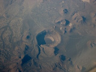
Lunar Crater volcanic field is a volcanic field in Nye County, Nevada. It lies along the Reveille and Pancake Ranges and consists of over 200 vents, mostly small volcanic cones with associated lava flows but also several maars, including one maar named Lunar Crater. Some vents have been eroded so heavily that the structures underneath the volcanoes have been exposed. Lunar Crater itself has been used as a testing ground for Mars rovers and as training ground for astronauts.
Pasto Ventura is an area in the Catamarca Province of Argentina. It features about 14 small Pleistocene volcanoes, mostly cinder cones with associated lava flows but also lava domes, tuff rings and two maars. The volcanoes are accompanied by pyroclastic deposits and their total volume reaches about 0.42 cubic kilometres (0.10 cu mi). Argon-argon dating has yielded ages ranging from 1.3 million years to about 270,000 years for volcanic rocks in the field.
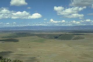
Tilocálar is a group of volcanoes south of the Salar de Atacama, in Chile. It developed during the Pleistocene and consists of a small lava dome, two vents with numerous thick lava flows that reach lengths of several kilometres, and an explosion crater that was mistaken for an impact crater in the past. There are similar volcanoes nearby.
References
- ↑ Guzmán, Petrinovic & Brod 2006, p. 51,52.
- 1 2 Guzmán, Petrinovic & Brod 2006, p. 52.
- ↑ Guzmán, Petrinovic & Brod 2006, p. 53.
- 1 2 "Gemelos-Saladillo". Global Volcanism Program . Smithsonian Institution.
- ↑ Guzmán, Petrinovic & Brod 2006, p. 54.
- 1 2 3 Guzmán, Petrinovic & Brod 2006, p. 55.
- ↑ Guzmán, Petrinovic & Brod 2006, p. 65.
- ↑ Guzmán, Petrinovic & Brod 2006, p. 61.
- ↑ Guzmán, Petrinovic & Brod 2006, p. 66.
Sources
- Guzmán, S.R.; Petrinovic, I.A.; Brod, J.A. (November 2006). "Pleistocene mafic volcanoes in the Puna–Cordillera Oriental boundary, NW-Argentina". Journal of Volcanology and Geothermal Research. 158 (1–2): 51–69. doi:10.1016/j.jvolgeores.2006.04.014. hdl: 11336/54200 . ISSN 0377-0273.