Reynosa is a border city in the northern part of the state of Tamaulipas, in Mexico which also holds the municipal seat of Reynosa Municipality.
Amacuzac is a city in the Mexican state of Morelos. The name means In the River of Yellow Amates. Amacuzac stands at 18°36′N99°23′W, at a mean height of 900 meters above sea level. The city serves as the municipal seat for the surrounding municipality of the same name. The municipality reported 17,772 inhabitants in the year 2015 census and covers a total surface area of 125 km2. The 2020 census reported 17,598 inhabitants in the municipality and 5,575 in the city of Amacuzac.
Emiliano Zapata is a city in the west-central part of the Mexican state of Morelos. It stands at 18°52′N99°09′W. The city serves as the county seat for the surrounding municipality of the same name. The municipality is the sixth largest in the state of Morelos, with a 2020 census population of 107,053 inhabitants, and has it an area of 64.983 km2. The city of Emiliano Zapata had 64,084 inhabitants in 2020. The city was previously known as both San Francisco Zacualpan and San Vicente Zacualpan. It was renamed in honor of Mexican Revolutionary Emiliano Zapata.

Yautepec is a municipality located in the north-central part of the Mexican state of Morelos. The municipal seat is the city of Yautepec de Zaragoza. It stands at 18°53′N99°04′W.

Juchitán de Zaragoza is an indigenous town in the southeast of the Mexican state of Oaxaca. It is part of the Juchitán District in the west of the Istmo de Tehuantepec region. With a 2020 census population of 88,280, it is the third-largest city in the state. The majority of the indigenous inhabitants are Zapotecs and Huaves. The town also serves as the municipal seat for the surrounding municipality, with which it shares a name. The municipality has an area of 414.64 km2 and a population of 113,570, the state's third-largest in population.

Cuautitlán, is a municipality in the State of Mexico, just north of the northern tip of the Federal District within the Greater Mexico City urban area. The city of Cuautitlán is the municipal seat and makes up most of the municipality. The name comes from Nahuatl and means 'between the trees.'

Almoloya de Juárez is a town in the State of Mexico and the seat of the municipality of Almoloya de Juárez. The name Almoloya comes from the Nahuatl, that is properly Almoloyan, composed of: atl, "water"; molo "impersonal voice of moloni, to flow the source" and yan, "place"; that it means "place where flows the water source".

Ciudad Nicolás Romero is the largest city and municipal seat of the municipality of Nicolás Romero in State of Mexico, Mexico. It is located 58 km from the city of Toluca, the state capital and lies in the north-central part of the state, just northwest of the Federal District. The seat/municipality's current name is to honor Nicolás Romero, who fought for Benito Juárez during the Reform War and the French intervention in Mexico. He was executed there by the French. The town adopted this name in 1898. The area was settled by the Otomi and named Azcapotzaltongo by the Aztecs after conquering it. During colonial times, it was known as San Pedro Azcapotzaltongo. It was then called Monte Bajo from 1821 to 1898, when the current name was adopted. Both the municipality and city are commonly referred to as Nicolás Romero.
Los Ramones is the name of a municipality and its corresponding seat of government and main population center in Mexican state of Nuevo Leon.
Melchor Ocampo is a municipality located in the Mexican state of Nuevo León. It is named after Don Melchor Ocampo, who was Foreign Minister during the government of Benito Juárez.

Ciudad Benito Juárez, or simply Juárez, is the name of a city located in the eastern part of the Monterrey metropolitan area in the state of Nuevo León, Mexico. It is the seat of the municipality of the same name. Ciudad Benito Juárez had a 2020 census population of 308,285 and is the sixth-largest city in Nuevo León. It shares borders with the municipalities of Pesquería to the north; to the south with Santiago; to the east with Cadereyta Jiménez; and to the west with Guadalupe.

Chicoloapan de Juárez is the municipal seat and largest city in the municipality of Chicoloapan in State of Mexico, Mexico. It is located in the eastern part of the state, just east of Chimalhuacán and northeast of the Federal District, within the Greater Mexico City urban area.

Apaseo el Grande is a city and municipality located in Guanajuato, Mexico. The municipality covers 415.26 square kilometres (160 sq mi). It is bordered on the north by Comonfort and San Miguel de Allende, on the east by Querétaro in the State of Querétaro on the south by Apaseo el Alto, and on the west by Celaya. The municipality had a population of 85,319 inhabitants according to the 2010 census.

Cárdenas is a municipality and city in the Mexican state of San Luis Potosí.

Tultepec is a city and municipality located in State of Mexico, Mexico. It lies directly north of Mexico City in the northeastern part of the State of Mexico, making it part of the Greater Mexico City urban area. The name comes from Náhuatl meaning 'hill of the 'tule'. The census of 2005 reported a population of 57,586 for the city and 110,145 for the municipality as a whole.
The municipality of Tenango del Valle is located in the southern portion of the Valley of Toluca in Mexico State, about 72 km southwest of Mexico City and 25 km south of Toluca. The municipal seat is the city of Tenango de Arista. While the seat is officially named Tenango de Arista, it is more commonly referred to as Tenango del Valle, as this was the original name of the town. Tenango del Valle is best known as the site of the Teotenango archeological site, which was a walled city inhabited from about 900 C.E. to 1550 C.E.

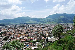
Tlaxiaco is a city, and its surrounding municipality of the same name, in the Mexican state of Oaxaca. It is located in the Tlaxiaco District in the south of the Mixteca Region, with a population of about 17,450.
Ixtlahuaca de Rayón is the municipal seat and 5th largest city in the municipality of Ixtlahuaca north of Toluca in the northwest part of the State of Mexico, in Mexico. The distance between Mexico City and Ixtlahuaca is 32 km. The name Ixthahuaca comes from Náhuatl and means plains without trees. The city and municipality were officially established by decree on November 14, 1816 by the Congress of the State of Mexico.

Santiago Papasquiaro is a municipality in the Mexican state of Durango. The municipal seat lies at Santiago Papasquiaro. The municipality covers an area of 7,238.4 km2. Santiago Papasquiaro municipality is at an average height of 1,730 m (5,675 ft) over the sea level. The municipality lies east of Sierra Madre Occidental Mountain Range. It neighbors with the municipalities of Canelas and Tepehuanes to the north, San Dimas and Otáez to the south, Nuevo Ideal to the east, Tamazula to the west and El Oro to the northeast.
Xochistlahuaca Municipality is a municipality in the Mexican state of Guerrero. The municipal seat lies at Xochistlahuaca. The municipality covers an area of 321.1 km².