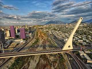
Monterrey is the capital and largest city of the northeastern state of Nuevo León, Mexico, and the second largest city in Mexico behind Mexico City. Located at the foothills of the Sierra Madre Oriental, the city is anchor to the Monterrey metropolitan area, the second-largest in Mexico with an estimated population of 5,341,171 people as of 2020 and the second most productive metropolitan area in Mexico with a GDP (PPP) of US$140 billion in 2015. According to the 2020 census, the city itself has a population of 1,142,194.
Santa Catarina is a city in Santa Catarina Municipality in the state of Nuevo León, Mexico that is part of the Monterrey Metropolitan area.

San Pedro Garza García(also known as San Pedro or Garza García) is a city-municipality of the Mexican state of Nuevo León and part of the Monterrey Metropolitan area. It is a contemporary commercial suburb of the larger metropolitan city of Monterrey between Puente de la Unidad and the Alfa Planetarium, including areas surrounding Calzada del Valle/Calzada San Pedro. In 2018 it was evaluated as having the best quality of life in México. It has luxury shopping malls, large green areas, as well as important colleges and hospitals. Cerro de Chipinque and Chipinque Ecological Park are notable aspects of the city. The city hosts the head offices of companies like ALFA, Cemex, Gamesa, Vitro, Pyosa, Softtek and Cydsa.
The governmental structures of Nuevo León, a Mexican state, are organized according to article 30 of the state constitution, which provides for a republican, representative and popular government, divided into three independent branches that cannot be joined together in a single person or institution. Nuevo León's relation with the federal government of Mexico places it in a similar relation to that federal government as any other Mexican state, but it retains certain aspects of sovereignty with respect to other Mexican states and even toward foreign countries, especially with reference to its own internal affairs.

Nuevo Laredo is a city in the Municipality of Nuevo Laredo in the Mexican state of Tamaulipas. The city lies on the banks of the Rio Grande, across from Laredo, United States. The 2010 census population of the city was 373,725. Nuevo Laredo is part of the Laredo-Nuevo Laredo Metropolitan Area with a population of 636,516. The municipality has an area of 1,334.02 km2 (515.07 sq mi). Both the city and the municipality rank as the third largest in the state.

San Nicolás de los Garza, sometimes known only as San Nicolás, is a city and coextensive municipality in the Mexican state of Nuevo León that is part of the Monterrey metropolitan area. It has become primarily a city for residences and family houses, although it still has several factories that tend to relocate to the periphery of the metropolitan area. It is the fifth-largest city in the state, behind Monterrey, Guadalupe, Ciudad Apodaca and General Escobedo.

Guadalupe is a city and surrounding municipality located in the state of Nuevo León, in northern Mexico. It is part of the Greater Monterrey Metropolitan area.
Nuevo León is a state in Northeast Mexico that is divided into 51 municipalities. According to the 2020 Mexican Census, it is the seventh most populated state with 5,784,442 inhabitants and the 13th largest by land area spanning 64,156.2 square kilometres (24,770.8 sq mi).

General Escobedo, or simply Escobedo, is a city and municipality in Nuevo León, Mexico that is part of the Monterrey Metropolitan area. As of the census of 2005, the population was 295,131 in the city and 299,364 in the municipality. The municipality has an area of around 149 km² and shares borders to the south with San Nicolás de los Garza, Monterrey and Santa Catarina; to the north with Hidalgo and El Carmen; to the east with Apodaca and Salinas Victoria; and to the west with García. Escobedo is also the home of the Mexican Army's 7th Military Zone Army Base.
Federal Highway 40, also called the Carretera Interoceánica, is a road beginning at Reynosa, Tamaulipas, just west of the Port of Brownsville, Texas, and ending at Fed. 15 in Villa Unión, Sinaloa, near Mazatlán and the Pacific coast. It is called Interoceanic as, once finished, the cities of Matamoros, Tamaulipas, on the Gulf of Mexico and Mazatlán on the Pacific Ocean will be linked.

The Monterrey metropolitan area refers to the surrounding urban agglomeration of Monterrey, Nuevo León. Officially called Area Metropolitana de la Ciudad de Monterrey or AMM, the metropolitan area is the 2nd-largest in Mexico.
Cadereyta Jiménez is the name of a city as well as of a municipality in the Mexican state of Nuevo León.

García is a city and municipality located to the northwest of the Monterrey metropolitan area in the state of Nuevo León, Mexico. The municipality had, according to the 2005 census, a population of 145,867. It borders the municipalities of Mina, Escobedo and Hidalgo to the north; to the south and east with Santa Catarina; and to the west with the state of Coahuila.

The Municipality of Nuevo Laredo is located in the Mexican state of Tamaulipas. Its municipal seat is Nuevo Laredo. The municipality contains more than 60 localities which the most important ones are Nuevo Laredo, El Campanario y Oradel, and Álvarez, the last two being suburbs of the city of Nuevo Laredo. By population, the municipality is the third largest in the state of Tamaulipas. The Nuevo Laredo municipality is the northernmost in Tamaulipas, lying at the extreme northwestern tip of its narrow strip of land along the Río Grande. The city of Nuevo Laredo contains approximately 97.5% of the total population of the municipality.
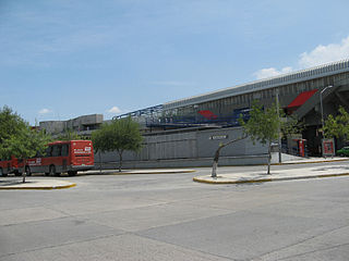
The Exposición Station is a terminal station on Line 1 of the Monterrey Metro. It is located on Juárez and Exposición Avenues in the La Hacienda neighborhood in Guadalupe, Nuevo León, Mexico. The station was opened on 25 April 1991 as the eastern end point or terminus of the inaugural section of Line 1, going from San Bernabé to Exposición.
Pesquería Municipality is a municipality of the state of Nuevo León in Mexico. It is located at 25º47´N 100º3´W and 330 metres (1,080 ft) above sea level. It is part of the suburban area of the Monterrey Metropolitan area. Its distance to the Monterrey city downtown area is 36 kilometres (22 mi). To the east of Pesquería is Los Ramones, to the north is Doctor González, to the west are Apodaca and General Mariano Escobedo International Airport, and to the south is Cadereyta Jiménez, all of which are in Nuevo León.

Allende Municipality is a municipality located in the northeastern Mexican state of Nuevo León. It comprises a region known as Región Citrícola, for being a major producer of orange at local, national and even international level. Allende is located at the Sierra Madre Oriental range foothills in the central-southeastern part in the state of Nuevo León. It has a territorial extension of 148.5 km², comprising around 0.22% of the whole extension of Nuevo León. Given its geographic location, the region consists of valleys and hills ranging from 300 meters above sea level on the northeast, to 1,640 meters above sea level in the southwestern part of the municipality. According to the 2010 census data, it had a population of 32,581, of whom 16,436 were men and 16,145 were women. The main economic activities are agriculture, livestock, beekeeping, poultry and transportation, activities that generate many jobs in the region. A sister city of Allende is Conroe, Texas.

Héctor Murguía Lardizábal is a Mexican politician. He has been a Senator, Federal Deputy in the LXI Legislature and served as Mayor of Ciudad Juarez for 2004-2007 and 2010-2013.

José Jerónimo de los Dolores Treviño y Leal, commonly known as Jerónimo Treviño was a prominent Mexican General and politician. He was a veteran of the Reform War and the Second French intervention in Mexico which he gained fame for his participation in several battles. After the fall of the Second Mexican Empire, Treviño served as the Governor of Nuevo León on several terms as well as the Secretary of War and Navy of Mexico from December 1, 1880, to December 31, 1881, under the cabinet of Manuel González Flores.