Related Research Articles

Interstate 95 (I-95) is the main north–south Interstate Highway on the East Coast of the United States, running from U.S. Route 1 (US 1) in Miami, Florida, north to the Houlton–Woodstock Border Crossing between Maine and the Canadian province of New Brunswick. The highway largely parallels the Atlantic coast and US 1, except for the portion between Savannah, Georgia, and Washington, D.C., and the portion between Portland and Houlton in Maine, both of which follow a more direct inland route.

Caroline County is a United States county located in the eastern part of the Commonwealth of Virginia. The northern boundary of the county borders on the Rappahannock River, notably at the historic town of Port Royal. The Caroline county seat is Bowling Green.

Watauga County is a county located in the U.S. state of North Carolina. As of the 2020 census, the population was 54,086. Its county seat and largest community is Boone. The county is in an exceptionally mountainous region. It is the home of Appalachian State University, which has approximately 20,023 students as of August 2020. Watauga County comprises the Boone, NC Micropolitan Statistical Area.

Jackson County is a county located in the western part of the U.S. state of North Carolina. As of the 2020 census, the population was 43,109. Since 1913, its county seat has been Sylva, which replaced Webster.

Ashe County is a county located in the U.S. state of North Carolina. As of the 2020 census, the population was 26,577. Its county seat is Jefferson.

Alleghany County is a county located in the U.S. state of North Carolina. As of the 2020 census, the population was 10,888. Its county seat is Sparta.
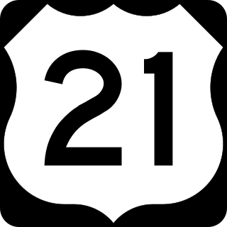
U.S. Route 21 or U.S. Highway 21 (US 21) is a major north–south United States Numbered Highway in the Southeastern United States that extends 394 miles (634 km). The southern terminus is in Hunting Island State Park, South Carolina, 14.4 miles (23.2 km) south of the junction with US 21 Business and South Carolina Highway 802 (SC 802) in Beaufort. The northern terminus is in Wytheville, Virginia, at an interchange with Interstate 81 (I-81) and US 52. Despite the "1" indicating that it is a major north–south highway, US 21 only travels through three states and is no longer a cross-country route as it has been replaced with I-77 in both Ohio and West Virginia. It also has the second-shortest length of all of the major north–south routes, just behind US 91. The route travels through the states of South Carolina, North Carolina, and Virginia. It also connects through major Southeastern cities such as Columbia, South Carolina, and Charlotte, North Carolina. The northern portion of the road travels parallel to I-77 in northern South Carolina and North Carolina. The road also has three interchanges with I-26 in Lexington and Calhoun counties in South Carolina.

U.S. Route 117 (US 117) is a north–south United States Highway located completely within the state of North Carolina. A spur route of US 17, the highway runs for 114 miles (183 km) from the Port of Wilmington, south of downtown Wilmington, to US 301 near Wilson. From its southern terminus, US 117 runs along Shipyard Boulevard and College Road, concurrent with North Carolina Highway 132 (NC 132) through Wilmington. US 117 intersects the eastern terminus of Interstate 40 (I-40) and parallels the interstate until reaching Faison, passing through Burgaw, Wallace, and Warsaw. The highway diverges from I-40 in Faison, running north-northeast through Mount Olive, Goldsboro, and Pikeville to its northern terminus. US 117 meets the southern end of I-795 in Goldsboro, and parallels that route before reaching its northern terminus at US 301 south of Wilson.
The Virginia Department of Transportation (VDOT) is the agency of the state government responsible for transportation in the state of Virginia in the United States. VDOT is headquartered at the Virginia Department of Highways Building in downtown Richmond. VDOT is responsible for building, maintaining, and operating the roads, bridges, and tunnels in the commonwealth. It is overseen by the Commonwealth Transportation Board, which has the power to fund airports, seaports, rail, and public transportation.

State Route 161 is a primary state highway in and near Richmond, Virginia, United States. It extends from an interchange with Interstate 95 (I-95) in the independent city of Richmond north to an intersection with U.S. Route 1 in the Lakeside area of central Henrico County.

Transportation in the Commonwealth of Virginia is by land, sea and air. Virginia's extensive network of highways and railroads were developed and built over a period almost 400 years, beginning almost immediately after the founding of Jamestown in 1607, and often incorporating old established trails of the Native Americans.
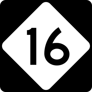
North Carolina Highway 16 (NC 16) is a 143.8-mile primary state highway in the U.S. state of North Carolina. Traveling in a north–south direction, it connects the cities and towns of Charlotte, Newton, Conover, Taylorsville, Wilkesboro and Jefferson, linking the Charlotte metropolitan area with the mountainous High Country. NC 16 is part of a three-state route 16 that connects the Charlotte region with northwestern West Virginia.

Western North Carolina is the region of North Carolina which includes the Appalachian Mountains; it is often known geographically as the state's Mountain Region. It contains the highest mountains in the Eastern United States, with 125 peaks rising to over 5,000 feet in elevation. Mount Mitchell at 6,684 feet, is the highest peak of the Appalachian Mountains and mainland eastern North America. The population of the region, as measured by the 2010 U.S. Census, is 1,473,241, which is approximately 15% of North Carolina's total population.
Interstate 95 (I-95) is a part of the Interstate Highway System that runs along the East Coast of the United States from Miami, Florida, to the Canada–United States border at Houlton, Maine. In the state of North Carolina, the route runs for 181.36 miles (291.87 km) from the South Carolina border near Rowland to the Virginia border near Pleasant Hill. The highway serves the cities of Lumberton, Fayetteville, Wilson, Rocky Mount, and Roanoke Rapids. The route goes through a mostly rural area of the state, avoiding most of the major metro areas of North Carolina. It forms the informal border between the Piedmont and Atlantic Plain regions of the state.

U.S. Route 15 (US 15) is a part of the United States Numbered Highway System that runs from Walterboro, South Carolina, to Painted Post, New York. In Virginia, the U.S. Highway runs 230.37 miles (370.74 km) from the North Carolina state line near Clarksville north to the Maryland state line at the Potomac River near Lucketts. US 15 is a major north–south highway through the Piedmont of Virginia, connecting Clarksville and Farmville in Southside with Culpeper, Warrenton, and Leesburg in Northern Virginia.
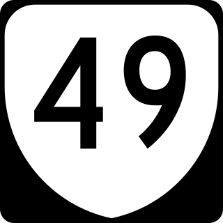
State Route 49 is a primary state highway in the U.S. state of Virginia. The state highway runs 69.01 miles (111.06 km) from the North Carolina state line in Virgilina, Virginia in Halifax County, where the highway continues south as North Carolina Highway 49, north to U.S. Route 360 near Burkeville in Nottoway County. SR 49 passes through Southside Virginia, connecting Virgilina and Burkeville with Clarksville and Chase City in Mecklenburg County, Victoria in Lunenburg County, and Crewe in Nottoway County. Via US 360, the state highway connects Richmond with the John H. Kerr Reservoir.
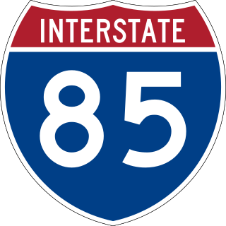
Interstate 85 (I-85) is an Interstate Highway that runs from Montgomery, Alabama, to Petersburg, Virginia. In North Carolina, I-85 travels 231.23 miles (372.13 km) from the South Carolina state line near Grover, North Carolina, to the Virginia state line near Wise. Despite being signed north–south, I-85 physically travels in a southwest–northeast direction across the state. The Interstate Highway connects the three most populous metropolitan areas of North Carolina: the Charlotte metropolitan area, Piedmont Triad, and Research Triangle, as well as nine of the 20 largest municipalities in the state. Outside of North Carolina, I-85 connects the state with Richmond, Virginia, to the north and Upstate South Carolina and Atlanta, Georgia, to the south. I-85 parallels several US Highways including US Highway 29 (US 29) between South Carolina and Greensboro, US 70 between Greensboro and Durham, US 15 between Durham and Oxford, and US 1 between Henderson and Virginia.

Eastern North Carolina is the region encompassing the eastern tier of North Carolina, United States. It is known geographically as the state's Coastal Plain region. Primary subregions of Eastern North Carolina include the Sandhills, the Lower Cape Fear, the Crystal Coast, the Inner Banks and the Outer Banks. It is composed of the 41 most eastern counties in the state. Cities include Greenville, Jacksonville, Wilmington, Rocky Mount and North Carolina's first capital New Bern.

U.S. Route 52 (US 52) is a north–south United States highway that runs for 150 miles (240 km) from the South Carolina state line, near McFarlan, to the Virginia state line, near Mount Airy. It serves as a strategic highway through the central North Carolina Piedmont. Because of its alignment in the state, US 52 does not follow the standard convention of an even U.S. route number going east–west.

The Appalachian region has always had to allocate much resources and time into transportation due to the region's notable and unique geography. Mountainous terrain and commonly occurring adverse weather effects such as heavy fog and snowfall made roads hazardous and taxing on the traveling vehicles. Initially, European settlers found gaps in the mountains, among them the Cumberland Gap and the Wilderness Road. Another notable challenge of Appalachian travel is the political elements of constructing transportation routes. Most travel systems are funded by municipalities, but since The Appalachian area has several different states it can be difficult for the various governments to agree on how to work on transportation. The most influential forms of travel in the Appalachian region are based on water trading routes, roads and railroads.
References
- ↑ Tabler, Dave (August 30, 2016). "The Lost Provinces". Appalachian History. Archived from the original on 5 February 2018. Retrieved 4 February 2018.
- ↑ Warmuth, Donna Akers; Akers, Donna Gayle (2003). Boone. Arcadia Publishing. p. 8. ISBN 978-0738515410.
- ↑ Williams, Cratis. "The New River Valley (N.C.) in Settlement Days". New River Gorge Symposium Proceedings 1984. National Park Service. Retrieved 4 February 2018.
- ↑ Powell, William S. (2006). "Lost Provinces". NCPedia. State Library of North Carolina. Retrieved 4 February 2018.