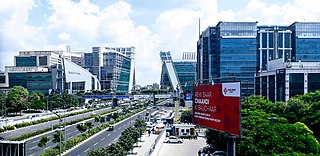
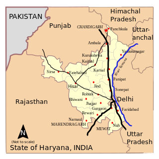
Haryana is an Indian state located in the northern part of the country. It was carved out of the former state of East Punjab on 1 Nov 1966 on a linguistic basis. It is ranked 21st in terms of area, with less than 1.4% of India's land area. The state capital is Chandigarh, which it shares with the neighboring state of Punjab, and the most populous city is Faridabad, which is a part of the National Capital Region. The city of Gurugram is among India's largest financial and technology hubs. Haryana has 6 administrative divisions, 22 districts, 72 sub-divisions, 93 revenue tehsils, 50 sub-tehsils, 140 community development blocks, 154 cities and towns, 7,356 villages, and 6,222 villages panchayats.

Yamunanagar, is a city and a municipal corporation in Yamunanagar district in the Indian state of Haryana. This town is known for the cluster of plywood units and paper factories. It provides timber to larger industries. The older town is called Jagadhri. The Yamunanagar-Jagadhri railway station (YJUD) services the city. Despite its name, Jagadhri Railway is situated in Yamunanagar. There is also another railway station called Jagadhri Workshop in Yamunanagar.

Ambala is a city and a municipal corporation in Ambala district in the state of Haryana, India, located on the border with the Indian state of Punjab and in proximity to both states capital Chandigarh. Politically, Ambala has two sub-areas: Ambala Cantonment and Ambala City, eight kilometres apart, therefore it is also known as "Twin City". It has a large Indian Army and Indian Air Force presence within its cantonment area. It is located 200 km (124 mi) to the north of New Delhi, India's capital, and has been identified as a counter-magnet city for the National Capital Region to develop as an alternative center of growth to Delhi.

Kurukshetra is a city and administrative headquarter of Kurukshetra district in the Indian state of Haryana. It is also known as Dharmakshetra and as the "Land of the Bhagavad Gita".

Sirsa is a city and a municipal council in Sirsa district in the westernmost region of the Indian state of Haryana, bordering Punjab and Rajasthan. It is located in Thar desert. It is located 250 kilometres north-west of New Delhi and 260 kilometres south-west of state capital Chandigarh. Sirsa Nearest city Hisar, Fatehabad, Bhadra, Nohar, Mandi Dabwali, Hanumangarh .Its history dates back to the time of the Mahabharata. At one time, the Sarasvati River flowed in this area.

Panchkula (PKL_Haryanvi) is a planned city and district headquarter in the Panchkula district, part of the Ambala division in Haryana, India. The origin of the name Panchkula came from the place where five irrigation canals meet. At present, it forms a part of an adjoining area to the Chandigarh, Mohali and Zirakpur. It is approximately 4 km (2.5 mi) southeast of Chandigarh, 105 km (65 mi) southwest of Shimla, 44 km (27 mi) from Ambala and 259 km (161 mi) northeast of New Delhi, the national capital. It is a part of the Chandigarh capital region or Greater Chandigarh. The Chandigarh-Mohali-Panchkula metropolitan region collectively forms a Chandigarh Tricity, with a combined population of over two million.
Rohtak is a city and the administrative headquarters of the Rohtak district in the Indian state of Haryana. It lies 70 kilometres (43 mi) north-west of New Delhi and 250 kilometres (160 mi) south of the state capital Chandigarh on NH 9(old NH 10). Rohtak forms a part of the National Capital Region (NCR) which helps the city in obtaining cheap loans for infrastructure development from the NCR Planning Board.

Ambala district is one of the 22 districts of Haryana state in the country of India with Ambala town serving as the administrative headquarters of the district. District Ambala lies on the North-Eastern edge of Haryana and borders Punjab and Himachal Pradesh. Ambala district is a part of Ambala Division.
The administrative divisions of India are subnational administrative units of India; they are composed of a nested hierarchy of administrative divisions.

Ambala Cantonment is a cantonment town in Ambala district in the state of Haryana, India. It is 200 km north of Delhi and 55 km southwest of Chandigarh. This cantonment was established in the year 1843 and is an important centre for manufacturing of scientific and surgical instruments.

Naraingarh is a city, municipal committee and assembly constituency in the Ambala district of the Indian state of Haryana, located on the border with the Indian state of Himachal Pradesh. Due to its geographical location, the Naraingarh plays an important role in local tourism, being located 39 km from Ambala city, the district headquarter, 52 km of Chandigarh, the state capital, 144 km of Shimla, and 230 km of New Delhi.
Banga is a town and Municipal council in the Shahid Bhagat Singh Nagar district of Punjab, India. Banga is also one of the sub-division (tehsil) headquarters of the district. Banga located on Phagwara-Rupnagar section of National Highway 344A. It is currently estimated to have a population of about 23,000 and is classified as a class 2 Municipality. The town also incorporates the former village of Jindowal apart from Banga town.

Haryana is a state in India. The state houses several sites from the Indus Valley Civilization, which was a cradle of civilization. In the Mahabharata, Haryana is mentioned as Bahudanayak Region.
Elections in Haryana, which is a state in India, have been conducted since 1967 to elect the members of state-level Haryana Legislative Assembly and national-level Lok Sabha. There are 90 assembly constituencies and 10 Lok Sabha constituencies.
Harbon is the notified area and village in Naraingarh Tehsil of Ambala district in the Indian State of Haryana. It is known for the cultivation of rice, wheat, barley and sugarcane. The production of the crops so obtained is supplied all over North India.

Chandigarh is a city and a union territory in the northern part of India that serves as the capital of the states of Punjab and Haryana. As a union territory, the city is ruled directly by the Union Government of India and is not part of either state.
Anil Mehta is a Bhartiya Janta Party (BJP) politician who is currently working as the Deputy Advocate General (DAG) for State of Haryana in Punjab & Haryana High Court at Chandigarh. He is also representing the Hon’ble Chief Minister of Haryana in a programme called "CONNECT2CM", an initiative of its own kind by any State Government wherein the Chief Minister would have a direct dialogue with youth from the age group of 16 to 35. The whole idea to launch this programme is to have the first hand information from the youth, the future of India with regard to the working and betterment of the State Government.
Shahzadpur is a Town in Shahzadpur Tehsil in Ambala District of Haryana State, India. It belongs to Ambala Division. It is located 30 km towards East from District headquarters Ambala. It is a Tehsil headquarter. Shahzadpur Pin code is 134202 and postal head office is Shahzadpur.
Sountli village Situated in Tehsil Shahzadpur Tehsil in Ambala District of Haryana State, India.It is located 26 km towards East from District headquarters Ambala. 3 km from Shahzadpur. 47 km from State capital Chandigarh.
Kurali is a Village, Village Council in the Ambala district of the Indian state of Haryana, located 8 km South to Naraingarh.

