Luba, Equatorial Guinea

Last updated
Luba
View on Luba, Bioko, 2013.JPG
Luba, 2013
Location map Bioko.png
Red pog.svg
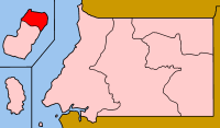
Luba
Location in Bioko
Equatorial Guinea location map.svg
Red pog.svg
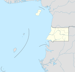
Luba
Luba (Equatorial Guinea)
Coordinates: 3°27′N8°33′E / 3.450°N 8.550°E / 3.450; 8.550 Coordinates: 3°27′N8°33′E / 3.450°N 8.550°E / 3.450; 8.550
CountryFlag of Equatorial Guinea.svg  Equatorial Guinea
Province Bioko Sur
Elevation
181 m (594 ft)
Population
(2012)
  City7,739
   Metro
24,000
Climate Am

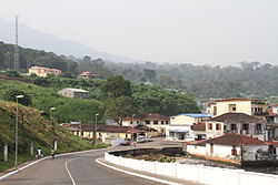
Luba (formerly San Carlos) (pop. 7,000) is the second-largest town on Bioko in Equatorial Guinea, a port for the logging industry on the island's west coast beneath volcanic peaks. Attractions in Luba include several beaches and a colonial hospital.

Bioko island

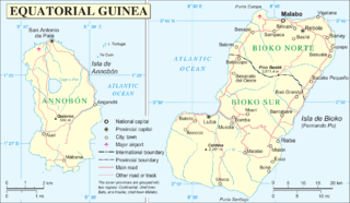
Bioko is an island 32 km (20 mi) off the west coast of Africa, and the northernmost part of Equatorial Guinea. Its population was 334,463 at the 2015 census and it covers an area of 2,017 km2 (779 sq mi). The island is located off Cameroon, in the Bight of Bonny portion of the Gulf of Guinea. Its geology is volcanic; its highest peak is Pico Basile at 3,012 m (9,882 ft).

Equatorial Guinea country in Africa

Equatorial Guinea, officially the Republic of Equatorial Guinea, is a country located on the west coast of Central Africa, with an area of 28,000 square kilometres (11,000 sq mi). Formerly the colony of Spanish Guinea, its post-independence name evokes its location near both the Equator and the Gulf of Guinea. Equatorial Guinea is the only sovereign African state in which Spanish is the official language. As of 2015, the country had an estimated population of 1,222,245.

Port maritime commercial facility

A port is a maritime commercial facility which may comprise one or more wharves where ships may dock to load and discharge passengers and cargo. Although usually situated on a sea coast or estuary, some ports, such as Hamburg, Manchester and Duluth, are many miles inland, with access from the sea via river or canal.

The city may be reached either by sea or by a main road linking Luba to the country's capital, Malabo. The road is now[ clarification needed ] accessible; it takes about an hour to drive from Malabo to Luba. In 1999, a free port opened near the town, creating deepwater access for larger and oil industry vessels, an alternative to the congested port of Malabo for re-supplying on fuel, water and other materials. [1] As of 2010 a new highway was under construction from Luba via Belebú Balachá through the Luba Crater Scientific Reserve to Ureca near the south coast. [2]

Malabo Place in Bioko Norte, Equatorial Guinea

Malabo is the capital of Equatorial Guinea and the province of Bioko Norte. It is located on the north coast of the island of Bioko, formerly known by the Bubis, its indigenous inhabitants, as Etulá, and as Fernando Pó by the Europeans. The city has a population of approximately 187,302 inhabitants.

Belebú Balachá in Bioko Sur, Equatorial Guinea

Belebú Balachá is a community on Bioko island in Equatorial Guinea. It is south of Luba, the second-largest town on the island, and just north of the Luba Crater Scientific Reserve. As of 2010 a new highway was under construction through the reserve from Belebu to Ureca but it cannot be confirmed if the highway was built.

Related Research Articles

Geography of Equatorial Guinea

The Republic of Equatorial Guinea is located in west central Africa. Bioko Island lies about 40 kilometers (24.9 mi) from Cameroon. Annobón Island lies about 595 kilometres (370 mi) southwest of Bioko Island. The larger continental region of Rio Muni lies between Cameroon and Gabon on the mainland; it includes the islands of Corisco, Elobey Grande, Elobey Chico, and adjacent islets.

Economy of Equatorial Guinea

Equatorial Guinea is a small nation of 1.2 million located on the west coast of Central Africa which gained independence from Spain in 1968. Thanks to the discovery and exploitation of significant oil reserves in the 1990s, it enjoys a purchasing power parity GDP per capita of more than US$38,699 which is as of 2016 the highest in Africa and the 31st highest in the world. However, the country has been ranked only 138th out of 188 countries on the United Nations Human Development Index in 2015. After the oil price collapsed in 2014, the economy has gone into a free for all which has put growth in a downwards spiral from around 15% to −10%.

Transport in Equatorial Guinea

This article lists transport in Equatorial Guinea.

Music of Equatorial Guinea

Equatorial Guinea's culture has been less documented than most African countries, and commercial recordings remain scarce.

Provinces of Equatorial Guinea

Equatorial Guinea is divided into two regions and eight provinces. The newest province is Djibloho, created in 2017 with its headquarters at Ciudad de la Paz, the country's future capital.

The Annobonese is a Portuguese creole known to its speakers as Fa d'Ambu or Fá d'Ambô. It is spoken on the Annobón and Bioko Islands off the coast of Equatorial Guinea, mostly by people of mixed African, Portuguese and Spanish descent. It is called annobonense or annobonés in Spanish.

Bioko Norte Province in Rebola, Equatorial Guinea

Bioko Norte is the most populated of the seven provinces of Equatorial Guinea. Both the provincial capital, Rebola, and the national capital, Malabo are located here. Heavily forested with little urban development, the southern central part includes part of the Parque Nacional del Pico Basilé, a 330 square kilometres (130 sq mi) national park which was established in 2000. On the northeast coast is a hotel run by the Sofitel chain.

Malabo International Airport airport

Malabo Airport or Saint Isabel Airport, is an airport located at Punta Europa, Bioko Island, Equatorial Guinea. The airport is named after the capital, Malabo, approximately 9 kilometres (5.6 mi) to the east.

Articles related to Equatorial Guinea include:

Segesa

SEGESA is the national electricity company of Equatorial Guinea, with its head offices in Malabo, Equatorial Guinea. It is the sole operator of the electricity sector of Equatorial Guinea. The company was created in November 2001 by a merger of the national rural electrification company SONER and the national electricity corporation ENERGE. In 2013 the company was reorganized into three units: SEGESA Comercial for distribution and sales, SEGESA Generación for generation activities and SEGESA Transmisión for transmission. The three units are overseen by SEGESA Holding.

Riaba Place in Bioko Sur, Equatorial Guinea

Riaba is a town in Equatorial Guinea. It is also the 30th largest settlement in the country. It was established by the British in 1821.

Pichinglis English-based creole of Equatorial Guinea

Pichinglis, commonly referred to by its speakers as Pichi and formally known as Fernando Po Creole English (Fernandino), is an Atlantic English-lexicon Creole language spoken on the island of Bioko, Equatorial Guinea. It is an offshoot of the Krio language of Sierra Leone, and was brought to Bioko by Krios who immigrated to the island during the colonial era in the 19th century.

The Mount Cameroon and Bioko montane forests ecoregion, of the tropical and subtropical moist broadleaf forests Biome, are in Afromontane habitats in Cameroon and Equatorial Guinea of Africa.

Insular Region (Equatorial Guinea) Equatorial Guinea

The Insular Region of Equatorial Guinea comprises the former Spanish territory of Fernando Po, together with Annobón island, the latter formerly part of the Spanish territory of Elobey, Annobón and Corisco, which was located in the Gulf of Guinea and in the Corisco Bay.

Aeroflot Flight 418 aviation accident

Aeroflot Flight 418 was an accident involving a Tupolev Tu-154A, registered CCCP-85102, that was operating the second leg of an international scheduled Luanda–Malabo–N'Djamena–Tripoli–Moscow passenger service that and crashed on 1 June 1976 into a mountain near Malabo Airport on Bioko Island, Equatorial Guinea.

Luba Crater Scientific Reserve

The Luba Crater Scientific Reserve is a protected area of 51,000 hectares on the volcanic island of Bioko, a part of Equatorial Guinea. The dense rainforest is rich in plant and animal species including a high population of primates, some endemic to the reserve. Much of the reserve consists of pristine forest. However, the primate population is under threat due to growing demand for bushmeat coupled with lack of enforcement of the ban on hunting in the reserve.

References

  1. "Welcome to Luba Freeport Ltd". Luba Freeport Ltd. Retrieved 2012-03-26.
  2. Cronin, Drew (September 2010). "OPPORTUNITIES LOST: THE RAPIDLY DETERIORATING CONSERVATION STATUS OF THE MONKEYS ON BIOKO ISLAND, EQUATORIAL GUINEA (2010)" (PDF). Universidad Nacional de Guinea Ecuatorial, Drexel University. p. 7. Archived from the original (PDF) on 2012-03-14. Retrieved 2012-03-25.