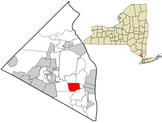
West Nyack is a hamlet and census-designated place in the town of Clarkstown, Rockland County, New York, United States. It is located north of Blauvelt, east of Nanuet, southwest of Valley Cottage, southeast of Bardonia, and west of Central Nyack. It is approximately 18 miles (29 km) north of New York City. The population was 3,439 at the 2010 census.

Sunbury is a city and the county seat of Northumberland County in Pennsylvania, United States. Located in the Susquehanna Valley, Sunbury is positioned on the east bank of the Susquehanna River.

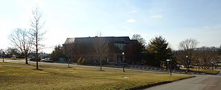
Lewisburg is a borough in Union County, Pennsylvania, United States, 30 miles (48 km) south by southeast of Williamsport and 60 miles (97 km) north of Harrisburg. The population was 5,158 as of the 2020 census. It is the county seat of Union County. Located in central Pennsylvania's Susquehanna Valley, on the West Branch Susquehanna River, it is home to Bucknell University. Its 19th-century downtown is listed on the National Register of Historic Places. Lewisburg is the principal city of the Lewisburg Micropolitan Statistical Area, and is also part of the larger Bloomsburg–Berwick–Sunbury Combined Statistical Area.

Brownsville is a city in and the county seat of Haywood County, Tennessee, United States. Its population as of the 2020 census was 9,788. The city is named after General Jacob Jennings Brown, an American officer of the War of 1812.

William Maclay was a politician from Pennsylvania during the eighteenth century. Maclay, along with Robert Morris, was a member of Pennsylvania's first two-member delegation to the United States Senate. He assisted John Harris, Sr. with the planning the layout of Harrisburg, Pennsylvania in 1785, where Maclay Street is named for him. Following his tenure in the Senate, he served in the Pennsylvania House of Representatives on two occasions, as a county judge, and as a presidential elector. He is known for his journal providing historical information on the 1st United States Congress.

Waterloo County was a county in Canada West in the United Province of Canada from 1853 until 1867, then in the Canadian province of Ontario from 1867 until 1973. It was the direct predecessor of the Regional Municipality of Waterloo.

God's Acre is a churchyard, specifically the burial ground. The word comes from the German word Gottesacker, an ancient designation for a burial ground. The use of "Acre" is related to, but not derived from the unit of measurement and can be of any size. In the early 17th century the term was used as a translation of the German, but by the end of the century, it was accepted as an English term.
Taylorstown is a small community in Loudoun County, Virginia, built on the banks of Catoctin Creek and the surrounding hillside, about two miles (3 km) south of the Potomac River. First settled in 1734, it holds two of the oldest standing houses in Loudoun County, "Hunting Hill" and "Foxton Cottage", directly across the Catoctin Creek from each other.
James Potter (1729–1789) was a soldier, farmer, and politician from Colonial- and Revolutionary-era Pennsylvania. He rose to the rank of brigadier general of Pennsylvania militia during the Revolutionary War, and served as Vice-President of Pennsylvania, 1781–1782.

Captain Abraham Flowers Lincoln was the paternal grandfather and namesake of the 16th U.S. president, Abraham Lincoln. Lincoln was a military captain during the American Revolution, and a pioneer settler of Kentucky. Some historical sources attest his last name as Linkhorn, although neither Abraham nor his children ever signed themselves as such.
Leavenworth is an unincorporated community located in Leavenworth Township in Brown County, Minnesota, United States. The elevation is 1,004 feet. It was situated on two locations in Brown County, one before the Dakota War of 1862, and in section 27 of the township along the Cottonwood River after the war.
Peach Point Plantation is a historic site located in Jones Creek, Brazoria County, Texas. It was a forced-labor farm and the homestead and domicile of many early Texas settlers, including Emily Austin Perry, James Franklin Perry, William Joel Bryan, Stephen Fuller Austin, and Guy Morrison Bryan. The land was operated as a working forced-labor farm producing cotton and sugar cane from 1832 until 1863.
Thomas Butler King I was an American politician from the state of Georgia. Late in life, King spent ten years in the newly admitted state of California and twice attempted to become a senator from that state.

Lavelle is a census-designated place that is located in Butler Township, Schuylkill County in the Commonwealth of Pennsylvania, in the United States. Situated on Pennsylvania Route 901, it was part of the Lavelle-Locustdale CDP for the 2000 census, before the communities were split into the two separate CDPs of Lavelle and Locustdale.

Limestone Run is a 5.8 miles (9.3 km) tributary of the West Branch Susquehanna River in Union County, Pennsylvania, which flows through East Buffalo Township, Buffalo Township and Lewisburg. Ludwig Derr once constructed a mill on the run, so one of its six tributaries is called Miller Run.
Lewisburg Cemetery is a historic cemetery in Lewisburg, Pennsylvania, United States. Located immediately to the north of Bucknell University, and dating to 1848, it is a contributing site of the Lewisburg Historic District. There are around 13,000 burials in the cemetery.

Market Street is a downtown street in Lewisburg, Pennsylvania, United States. It runs for around 1.6 miles (2.6 km), from Main Street, at the Union County/Northumberland County line, in the east to North Fairground Road in the west. It is part of Pennsylvania Route 45. West of its intersection with Derr Drive, it is named West Market Street. From the West Branch Susquehanna River inland, Market Street's cross streets are numbered 2 through 8, with Front Street replacing what was originally 1st Street. These cross streets are named "North" or "South" depending on their location relative to Market Street Street. Lewisburg's street layout was designed by Ludwig Derr in 1785, and is believed to have been inspired by that of Philadelphia.

University Avenue is a downtown street in Lewisburg, Pennsylvania, United States. It runs for around 0.19 miles (0.31 km), from St. George Street in the north to Loomis Street in the south. It was the original main access road to the University at Lewisburg, located on the northern side of the campus, and still leads to its former main entrance, punctuated by the 1905 Memorial Gateway. The Grove, a wooded area, stands inside the gates.
Joseph A. Boggs was an American Army officer. Ranked Lieutenant, he fought in the American Revolutionary War.
7th Street is a downtown street in Lewisburg, Pennsylvania, United States. It runs for around 1.06 miles (1.71 km), from North 10th Street, in the northwest, to River Road in the southeast. North of its intersection with Market Street, it is named North 7th Street; south of it, it is South 7th Street. From the West Branch Susquehanna River inland, Market Street's cross streets are numbered 2 through 8, with Front Street replacing what was originally 1st Street. Lewisburg's street layout was designed by Ludwig Derr in 1785, and is believed to have been inspired by that of Philadelphia.

