Lungtan

Last updated

Lungtan
village
Location map India Mizoram EN.svg
Red pog.svg
Lungtan
Location in Mizoram, India
India location map.svg
Red pog.svg
Lungtan
Lungtan (India)
Coordinates: 23°23′02″N93°06′03″E / 23.3837587°N 93.1008348°E / 23.3837587; 93.1008348 Coordinates: 23°23′02″N93°06′03″E / 23.3837587°N 93.1008348°E / 23.3837587; 93.1008348
Country India
State Mizoram
District Champhai
Block Khawzawl
Elevation1,247 m (4,091 ft)
Population (2011)
  Total658
Time zone UTC+5:30 (IST)
2011 census code271334

Lungtan is a village in the Champhai district of Mizoram, India. It is located in the Khawzawl R.D. Block. [1]

Champhai district District of Mizoram in India

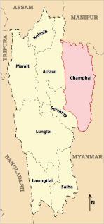
Champhai district is one of the eight districts of Mizoram state in India. The district is bounded on the north by Churachandpur district of Manipur state, on the west by Aizawl and Serchhip districts, and on the south and east by Myanmar. The district occupies an area of 3185.83 km². Champhai town is the administrative headquarters of the district.

Mizoram State in North-east India

Mizoram is a state in northeastern India, with Aizawl as its capital city. The name is derived from "Mizo", the name of the native inhabitants, and "Ram", which means land, and thus Mizoram means "land of the Mizos". Within the northeast region, it is the southernmost landlocked state, sharing borders with three of the Seven Sister States, namely Tripura, Assam and Manipur. The state also shares a 722 kilometre border with the neighbouring countries of Bangladesh and Myanmar.

India Country in South Asia

India, also known as the Republic of India, is a country in South Asia. It is the seventh largest country by area and with more than 1.3 billion people, it is the second most populous country as well as the most populous democracy in the world. Bounded by the Indian Ocean on the south, the Arabian Sea on the southwest, and the Bay of Bengal on the southeast, it shares land borders with Pakistan to the west; China, Nepal, and Bhutan to the northeast; and Bangladesh and Myanmar to the east. In the Indian Ocean, India is in the vicinity of Sri Lanka and the Maldives, while its Andaman and Nicobar Islands share a maritime border with Thailand and Indonesia.

Demographics

According to the 2011 census of India, Lungtan has 115 households. The effective literacy rate (i.e. the literacy rate of population excluding children aged 6 and below) is 96.29%. [2]

Demographics (2011 Census) [2]
TotalMaleFemale
Population658340318
Children aged below 6 years1195960
Scheduled caste 000
Scheduled tribe 658340318
Literates519272247
Workers (all)354193161
Main workers (total)354193161
Main workers: Cultivators318173145
Main workers: Agricultural labourers220
Main workers: Household industry workers1275
Main workers: Other221111
Marginal workers (total)000
Marginal workers: Cultivators000
Marginal workers: Agricultural labourers000
Marginal workers: Household industry workers000
Marginal workers: Others000
Non-workers304147157

Related Research Articles

Hnahlan village in Mizoram, India

Hnahlan is a village in the Champhai district of Mizoram, India. It is located in the Champhai R.D. Block. It is the largest grapes producer village of India.

Kawlbem village in Mizoram, India

Kawlbem is a village in the Champhai district of Mizoram, India. It is located in the Ngopa R.D. Block.

Mimbung village in Mizoram, India

Mimbung is a village in the Champhai district of Mizoram, India. It is located in the Ngopa R.D. Block.

Khuangthing village in Mizoram, India

Khuangthing is a village in the Champhai district of Mizoram, India. It is located in the Khawbung R.D. Block.

North Khawbung village in Mizoram, India

North Khawbung is a village located in Champhai district of Mizoram, India. It is located in the Champhai R.D. Block.

Khuangphah village in Mizoram, India

Khuangphah is a village in the Champhai district of Mizoram, India. It is located in the Champhai R.D. Block.

Pamchung village in Mizoram, India

Pamchung is a village in the Champhai district of Mizoram, India. It is located in the Khawzawl R.D. Block.

Rabung village in Mizoram, India

Rabung is a village in the Champhai district of Mizoram, India. It is located in the Khawzawl R.D. Block.

Puilo village in Mizoram, India

Puilo is a village in the Champhai district of Mizoram, India. It is located in the Khawzawl R.D. Block.

Ngaizawl village in Mizoram, India

Ngaizawl is a village in the Champhai district of Mizoram, India. It is located in the Khawzawl R.D. Block.

Kawlkulh village in Mizoram, India

Kawlkulh is a village in the Champhai district of Mizoram, India. It is located in the Khawzawl R.D. Block.

E. Chawngtui village in Mizoram, India

E. Chawngtui is a village in the Champhai district of Mizoram, India. It is located in the Khawbung R.D. Block.

Tualcheng village in Mizoram, India

Tualcheng is a village in the Champhai district of Mizoram, India. It is located in the Champhai R.D. Block.

Vapar village in Mizoram, India

Vapar is a village in the Champhai district of Mizoram, India. It is located in the Champhai R.D. Block.

Mualzen village in Mizoram, India

Mualzen is a village in the Champhai district of Mizoram, India. It is located in the Khawzawl R.D. Block.

Murlen village in Mizoram, India

Murlen is a village in the Champhai district of Mizoram, India. It is located in the Champhai R.D. Block.

Buang village in Mizoram, India

Buang is a village in the Champhai district of Mizoram, India. It is located in the Khawbung R.D. Block.

Ngur village in Mizoram, India

Ngur is a village in the Champhai district of Mizoram, India. It is located in the Champhai R.D. Block.

Kelkang village in Mizoram, India

Kelkang is a village in the Champhai district of Mizoram, India. It is located in the Khawzawl R.D. Block.

Zawlsei village in Mizoram, India

Zawlsei is a village in the Champhai district of Mizoram, India. It is located in the Khawbung R.D. Block.

References

  1. "Mizoram villages" (PDF). Land Records Information Systems Division, NIC. Retrieved 2015-08-22.
  2. 1 2 "District Census Handbook - Champhai" (PDF). 2011 Census of India . Directorate of Census Operations, Mizoram. Retrieved 2015-08-22.