Luremo

Last updated
Luremo
Angola location map.svg
Red pog.svg
Luremo
Location in Angola
Coordinates: 8°30′57″S17°49′45″E / 8.51583°S 17.82917°E / -8.51583; 17.82917
CountryFlag of Angola.svg  Angola
Province Lunda Norte
Area
  Total4,404 km2 (1,700 sq mi)
Population
 (2014)
  Total22,587
Time zone UTC+1 (WAT)

Luremo is a town and commune of Angola, located in the municipality of Cuango in the province of Lunda Norte. [1] It lies along the eastern segment of Estrada Nacional 225 north of the town of Cafunfo, which terminates at Muginga. To the north, it shares a border with Kwango Province of the Democratic Republic of the Congo. [2] [3]

Contents

History

Luremo's history can be traced back to 1899, when it was a Portuguese military fort and mission in the then-province of Lunda. [4] In 1900, the first missionaries sent by the Portuguese government arrived in the village of Musuku and built a chapel and missionary residence, and then five years later, opened a boarding school for boys. Other chapels and missionary residences were built afterwards. [5] Lunda was split into Lunda Norte and Lunda Sul by the revolutionary government in 1978. [6] Luremo has since grown to a town with an estimated population of around 30,000 people living in the commune by 2023. [4]

In 2003-2006, the Angolan government enacted Operation Brilliant, an action to combat illegal diamond mining and smuggling by rebel groups and undocumented Congolese miners, in which hundreds of thousands of people were deported to the DRC. These people were driven to Luremo in cramped military trucks, searched, often in invasive and degrading ways, and then forced to walk, without access to food, water, or sanitation, the last 65 kilometers to the Congolese border. [7]

In April 2024, the Mission of the Sacred Heart of Jesus of Musuku was one of six sites proposed by the Provincial Government of Lunda-Norte to the Ministry of Culture, Tourism and the Environment to be declared a National Heritage. [5] [8]

Economy

Diamond mining

Luremo contains deposits of diamonds and is highly reliant on alluvial diamond mining for its economy, [4] with mines such as Luminas employing hundreds of people. [9] These mines have received allegations of human rights abuses perpetrated both by police and by private security companies, with reports of detainment without cause, confiscation of property for ransom, harsh and unhygienic working conditions, murder, and rape. [10] [11]

Agriculture

Luremo also has fertile land and an agricultural sector, which produces a wide variety of foods, including vegetables, beans, corn, cassava, and sweet potato, however farming is done by hand rather than in a modern, mechanized fashion due to lack of tools, and much of this capacity is currently devoted to subsistence agriculture. In 2023, interim administrator José Muheto told Jornal de Angola his belief that Luremo could provide food for nearby communities such as Cuango, Xá-Muteba and Capenda-Camulemba if this agricultural sector could be better supported. [4]

Infrastructure and trade

There is a lack of economic diversification and commercial activity in town. Exacerbated by a lack of infrastructure, this often forces residents to travel 35 kilometers down EN-225, a dirt road, to Cafunfo to obtain goods and supplies. There is no bank in Luremo as of 2023. A public drinking water system is still under construction. [4]

The Kwango River flows through the West side of Luremo, and Muheto stated hopes that it can be utilized to facilitate cross-border trade with communities in the DRC. [4]

Luremo is serviced by an airstrip. In 1996, an Antonov AN-32B belonging to the Ukraine Air Alliance overran the runway while talking off, causing damage that caused it to be written off but with no casualties. [12]

Luremo is among the towns designated by the Minister of Energy and Water, João Baptista Borges, to host one of fifteen solar power facilities as part of the Rural Electrification initiative in Lunda Norte, which aims to generate 256 megawatts of solar power across the province by 2027. [13]

Demographics

Religion

The vast majority of the population are Christian, with over half the population (52.9%) reporting as Protestant in 2014 and 31.8% as Catholic. 14% reported affiliation with no religion. [2]

Education

In the 2014 census, only half the adult population of Luremo was literate [2] , owing to a lack of teachers in the town. In 2023, there were as few as only ten teachers in the Luremo school network, which goes up to ninth grade. [4]

See also

Related Research Articles

<span class="mw-page-title-main">Culture of Angola</span>

The culture of Angola is influenced by the Portuguese. Portugal occupied the coastal enclave Luanda, and later also Benguela, since the 16th/17th centuries, and expanded into the territory of what is now Angola in the 19th/20th centuries, ruling it until 1975. Both countries share prevailing cultural aspects: the Portuguese language and Roman Catholicism. However, present-day Angolan culture is mostly native Bantu, which was mixed with Portuguese culture. The diverse ethnic communities with their own cultural traits, traditions and native languages or dialects include the Ovimbundu, Ambundu, Bakongo, Chokwe, Avambo and other peoples.

<span class="mw-page-title-main">Lunda Norte Province</span> Province of Angola

Lunda Norte is a province of Angola. It has an area of 103,760 km² and a population of 862,566. Angola's first President, Agostinho Neto, made Lucapa the provincial capital after independence, but the capital was later moved to Dundo. The province borders the Democratic Republic of Congo in the northeast and Lunda Sul in the south. The province is rich in gold and diamonds, but remains vastly underdeveloped and impoverished. UNITA used the money generated from the sale of diamonds to fund war efforts. Cuango River valley, the richest diamond area of Angola is located in the province. Mining is done by notable companies like DeBeers and Endiama. The Lunda province whose capital was Saurimo was created by the Portuguese colonial empire on July 13, 1895. It was divided into Lunda-Sul and Lunda-Norte subdivisions through a constitution act in 1978 by the People's Movement for the Liberation of Angola (MPLA) government. Iron and manganese mining are also important economic activities. It is well known for its sculptures. The most notable one is The Thinker, a sculpture of a man holding his head. It is rich in terms of flora and fauna.

<span class="mw-page-title-main">Lunda Sul Province</span> Province of Angola

Lunda Sul is a province of Angola. It has an area of 77,637 km2 and a 2014 census population of 537,587. Saurimo is the provincial capital.

<span class="mw-page-title-main">Malanje Province</span> Province of Angola

Malanje is a province of Angola. It has an area of 97,602 km2 and a 2014 census population of 986,363. Malanje is the provincial capital.

<span class="mw-page-title-main">Kasai River</span> Tributary of the Congo River; part of the DR Congo-Angola border

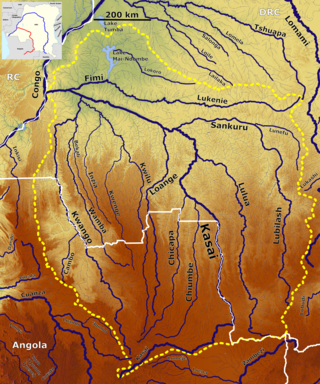
The Kasai River is a left bank tributary of the Congo River, located in Central Africa. The river begins in central Angola and flows to the east until it reaches the border between Angola and the Democratic Republic of the Congo, where it turns north and serves as the border until it flows into the DRC. From Ilebo, between the confluences with Lulua river and Sankuru river, the Kasai river turns to a westerly direction. The lower stretch of the river, from the confluence with Fimi river until it joins the Congo at Kwamouth northeast of Kinshasa, is also known as the Kwa(h) River.

Dundo, or Dundo-Chitato, is a former mining town, with a population of 177,604 (2014), now a city and the provincial capital of Lunda Norte in Angola. Established in the early part of the 20th century as a planned diamond mining community, Dundo has continued to grow, has its own airport and is now being superseded by a new city, New Dundo.

<span class="mw-page-title-main">Endiama</span>

Endiama E.P. is the national diamond company of Angola and it is the exclusive concessionary of mining rights in the domain of diamonds. Angola's state-run diamond company Endiama produced 8.55 million carats of diamonds in 2010.

Cafunfo is a town, with a population of 90,000 (2014), in North-Eastern Angola dominated by the informal and formal diamond mining industries. The area has numerous alluvial diamond deposits.

The Jaga or Jagas were terms applied by the Portuguese to tribes such as Yaka, Suku, Teke, Luba, Kuba and Hungaan invading bands of African warriors east and south of the kingdom of Kongo. The use of the phrase took on different connotations depending on where it was applied. There were two groups of people, both known as fierce warriors, who were dubbed jagas or the jaga. Unbeknownst to the Portuguese who encountered these warriors, the two groups were practically unrelated.

Cuango, also Cuango-Luzamba or Luzamba, is a town and municipality in Lunda Norte Province in Angola. The municipality had a population of 183,767 in 2014. It is served by Luzamba Airport.

General Adriano Makevela Mackenzie is a prominent Angolan general in the Lunda Norte Province.

Kasongo Lunda is a territory in the Democratic Republic of Congo, located in Kwango Province. The capital lies at Kasongo Lunda. It is the second biggest territory in Congo, located near to the border with Angola.

<span class="mw-page-title-main">Kwango River</span> River in Central Africa; forms part of the border between Angola and the DRC

The Cuango or Kwango is a transboundary river of Angola and Democratic Republic of Congo. It is the largest left bank tributary of the Kasai River in the Congo River basin. It flows through Malanje in Angola. The Kwango River basin has large resources of diamonds in the Chitamba-Lulo Kimberlite Cluster in Lunda Norte Province, discovered in the main river channel and on flats and terraces in its flood plains.

<span class="mw-page-title-main">Kwango</span> Province of the Democratic Republic of the Congo

Kwango is a province of the Democratic Republic of the Congo. It's one of the 21 provinces created in the 2015 repartitioning. Kwango, Kwilu, and Mai-Ndombe provinces are the result of the dismemberment of the former Bandundu province. Kwango was formed from the Kwango district whose town of Kenge was made the provincial capital and thus gained city status.

Cuango-Luzamba Airport is an airport serving Cuango-Luzamba, in the Lunda Norte Province of Angola. The airport is known for its unrecovered wrecks.

Cambulo is a town and municipality in northeast Angola. The municipality had a population of 120,127 in 2014.

<span class="mw-page-title-main">Wamba River</span> River in Democratic Republic of the Congo, Angola

The Wamba River is a river in the Democratic Republic of the Congo (DRC) and Angola. It arises at an elevation of around 3,250 feet (990 m) as the confluence of several small streams in the Lunda Norte Province of Angola, a region of low hills and shallow ravines. In Angola it is known as the Uamba River.

<span class="mw-page-title-main">Angola–Democratic Republic of the Congo border</span> International border

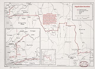
The Angola–Democratic Republic of the Congo border is 2,646 km in length and consists of two non-contiguous sections: a 225 km section along the border with Angola's province of Cabinda, running from the Atlantic Ocean to the tripoint with the Republic of Congo, and a much longer 2,421 km section running from the Atlantic to the tripoint with Zambia.

Events in the year 2022 in Angola.

<span class="mw-page-title-main">Os Kiezos</span> Angolan group of musicians

Os Kiezos is the name of a musical ensemble (conjunto) that emerged in 1963 in Marçal, a neighbourhood of Luanda. Known particularly within the genre of semba and Latin music like merengue, rumba and bolero. Os Kiezos are considered to be one of the most influential musical groups from Angola.

References

  1. "Census 2014". Official Portal of the 2014 INE Angola Census. Archived from the original on 4 March 2016. Retrieved 30 May 2018.
  2. 1 2 3 "Luremo (Commune, Angola) - Population Statistics, Charts, Map and Location". www.citypopulation.de. Retrieved 2024-07-24.
  3. "Luremo". google maps. Retrieved 30 May 2018.
  4. 1 2 3 4 5 6 7 Sapalo, Armando. "Luremo quer contar com mais investidores do sector não diamantífero". Jornal de Angola (in Portuguese). Retrieved 2024-07-24.
  5. 1 2 grxnet.com. "Jornal de Angola - Notícias - Monumentos e sítios marcam a herança histórica e sociocultural da Lunda-Norte". Jornal de Angola (in Portuguese). Retrieved 2024-07-24.
  6. James, W. Martin; Broadhead, Susan H. (2004). Historical dictionary of Angola. Historical dictionaries of Africa (New ed.). Lanham, Md: Scarecrow Press. ISBN   978-0-8108-4940-2.
  7. "Inhumane Treatment of Diamond Miners in Angola Continues". Doctors Without Borders - USA. Retrieved 2024-07-24.
  8. grxnet.com. "Jornal de Angola - Notícias - Lunda-Norte propõe cinco novos locais a Património". Jornal de Angola (in Portuguese). Retrieved 2024-07-24.
  9. "Participações". Endiama (in European Portuguese). Retrieved 2024-07-24.
  10. "גלובס עיתון העסקים של ישראל – "היכו אותי עד שהתעלפתי. כששבתי להכרה היה חושך. למחרת זחלתי חזרה". עדויות מהמכרה בו שותף לבייב". web.archive.org. 2009-01-15. Retrieved 2024-07-24.
  11. "[PDF] full report: "Lundas - The Stones of Death, Angola's deadly diamonds: Human Rights Abuses in the Lunda Provinces, 2004"". Business & Human Rights Resource Centre. Retrieved 2024-07-24.
  12. "Runway excursion Accident Antonov An-32B UR-48008,". mail.aviation-safety.net. Retrieved 2024-07-24.
  13. grxnet.com. "Jornal de Angola - Notícias - Planos do sector da Energia prevêem 15 parques solares". Jornal de Angola (in Portuguese). Retrieved 2024-07-24.

8°31′S17°50′E / 8.517°S 17.833°E / -8.517; 17.833