Yosemite National Park is an American national park in the state of California, surrounded on the southeast by Sierra National Forest and on the northwest by Stanislaus National Forest. The park is managed by the National Park Service and covers an area of 759,620 acres in four counties – centered in Tuolumne and Mariposa, extending north and east to Mono and south to Madera County. Designated a World Heritage Site in 1984, Yosemite is internationally recognized for its cliffs, waterfalls, clear streams, giant sequoia groves, lakes, mountains, meadows, glaciers, and biological diversity. Almost 95 percent of the park is designated wilderness. Yosemite is one of the largest and least fragmented habitat blocks in the Sierra Nevada, and the park supports a diversity of plants and animals.

The Sierra Nevada is a mountain range in the Western United States, between the Central Valley of California and the Great Basin. The vast majority of the range lies in the state of California, although the Carson Range spur lies primarily in Nevada. The Sierra Nevada is part of the American Cordillera, an almost continuous chain of mountain ranges that forms the western "backbone" of the Americas.

The exposed geology of the Yosemite area includes primarily granitic rocks with some older metamorphic rock. The first rocks were laid down in Precambrian times, when the area around Yosemite National Park was on the edge of a very young North American continent. The sediment that formed the area first settled in the waters of a shallow sea, and compressive forces from a subduction zone in the mid-Paleozoic fused the seabed rocks and sediments, appending them to the continent. Heat generated from the subduction created island arcs of volcanoes that were also thrust into the area of the park. In time, the igneous and sedimentary rocks of the area were later heavily metamorphosed.

William Maclure was an Americanized Scottish geologist, cartographer and philanthropist. He is known as the 'father of American geology'. As a social experimenter on new types of community life, he collaborated with British social reformer Robert Owen, (1771–1854), in Indiana, United States.

The Merced River, in the central part of the U.S. state of California, is a 145-mile (233 km)-long tributary of the San Joaquin River flowing from the Sierra Nevada into the San Joaquin Valley. It is most well known for its swift and steep course through the southern part of Yosemite National Park, where it is the primary watercourse flowing through Yosemite Valley. The river's character changes dramatically once it reaches the plains of the agricultural San Joaquin Valley, where it becomes a slow-moving meandering stream.

The Tuolumne River flows for 149 miles (240 km) through Central California, from the high Sierra Nevada to join the San Joaquin River in the Central Valley. Originating at over 8,000 feet (2,400 m) above sea level in Yosemite National Park, the Tuolumne drains a rugged watershed of 1,958 square miles (5,070 km2), carving a series of canyons through the western slope of the Sierra. While the upper Tuolumne is a fast-flowing mountain stream, the lower river crosses a broad, fertile and extensively cultivated alluvial plain. Like most other central California rivers, the Tuolumne is dammed multiple times for irrigation and the generation of hydroelectricity.

Cathedral Peak is part of the Cathedral Range, a mountain range in the south-central portion of Yosemite National Park in eastern Mariposa and Tuolumne Counties. The range is an offshoot of the Sierra Nevada. The peak which lends its name to the range derives its name from its cathedral-shaped peak, which was formed by glacial activity: the peak remained uneroded above the glaciers in the Pleistocene.

Mount Lyell is the highest point in Yosemite National Park, at 13,114 feet (3,997 m). It is located at the southeast end of the Cathedral Range, 1+1⁄4 miles northwest of Rodgers Peak. The peak as well as nearby Lyell Canyon is named after Charles Lyell, a well-known 19th century geologist. The peak had one of the last remaining glaciers in Yosemite, Lyell Glacier. The Lyell Glacier is currently considered to be a permanent ice field, not a living glacier. Mount Lyell divides the Tuolumne River watershed to the north, the Merced to the west, and the Rush Creek drainage in the Mono Lake Basin to the southeast.

Mount Darwin is a flat-topped mountain in the Sierra Nevada, on the border of between Fresno and Inyo counties in Kings Canyon National Park and the John Muir Wilderness of California.

The Palisade Glacier is a glacier located on the northeast side of the Palisades within the John Muir Wilderness in the central Sierra Nevada of California. The glacier descends from the flanks of four fourteeners, or mountain peaks over 14,000 ft (4,300 m) in elevation, including North Palisade, the highest peak of the Palisades group and the third highest peak in the Sierra Nevada overall.

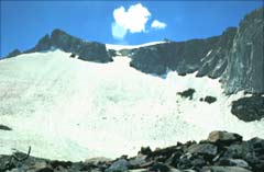
Maclure Glacier is on Mount Maclure in the Sierra Nevada crest of Yosemite National Park in Tuolumne County, California, United States. The glacier is named after William Maclure. Like most glaciers in the Sierra Nevada, Maclure Glacier is a small cirque glacier that is .20 mi (0.32 km) long and covers an area of only .08 sq mi (0.21 km2). The mean elevation of the glacier is around 11,400 ft (3,500 m). Both the Maclure Glacier and the Lyell Glacier, located nearby on Mount Lyell, have retreated since their first discovery.

Falling Ice Glacier is located in the Grand Teton National Park, Wyoming, United States. The glacier is situated on the southeastern cliffs of Mount Moran and can be seen from Jackson Hole. Runoff from the glacier flows into Leigh Lake. The glacier is located in a high altitude cirque and is along one of the major climbing routes to the summit of Mount Moran. All of the existing glaciers in Grand Teton National Park were created during the Little Ice Age (1350–1850 A.D.) and have been in a general state of retreat since the mid-19th century.
Mount Maclure is the nearest neighbor to Mount Lyell, the highest point in Yosemite National Park. Mount Maclure is the fifth-highest mountain of Yosemite. Mount Maclure is located at the southeast end of the Cathedral Range, about 0.6 miles (0.97 km) northwest of Lyell. The summit is on the boundary between Madera and Tuolumne counties which is also the boundary between the park and the Ansel Adams Wilderness. It was named in honor of William Maclure, a pioneer in American geology who produced the first geological maps of the United States. Maclure Glacier, one of the last remaining glaciers in Yosemite, is situated on the mountain's northern flank.
Darwin Glacier is a mountain glacier located on the north side of Mount Darwin in the Sierra Nevada, California. The glacier is located in Kings Canyon National Park. The glacier inherited its name from Mount Darwin, named for Charles Robert Darwin. In 2004, a study found that since 1900, Darwin Glacier had lost half its surface area.

The Matthes Glaciers are a group of glaciers east of the Glacier Divide in the Sierra Nevada, in the U.S. state of California. The glaciers were named for François E. Matthes. There are approximately 10 small glacierets situated above 12,200 feet (3,700 m) in the John Muir Wilderness of Sierra National Forest which comprise the Matthes Glaciers.
Goethe Glacier is a small glacier located in the Sierra Nevada Range in the John Muir Wilderness of Sierra National Forest in the U.S. state of California. The glacier is northwest of Mount Goethe.
Powell Glacier is located in the Sierra Nevada Range in the U.S. state of California. Just to the northeast of Mount Powell, the glacier is within the John Muir Wilderness of Inyo National Forest at an elevation of 12,523 ft (3,817 m).

Hiking, rock climbing, and mountain climbing around Tuolumne Meadows in Yosemite National Park has many options.