
Lynwood is a small town located in the Northern Rivers Region of New South Wales. [2] It had a population of 228 in the 2016 census. [1]
Lynwood is a small town located in the Northern Rivers Region of New South Wales. [2] It had a population of 228 in the 2016 census. [1]
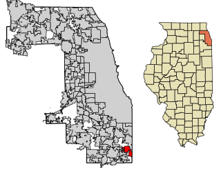
Lynwood is a village in Cook County, Illinois, United States and a suburb of Chicago. The population was 9,007 at the 2010 census.

Blaenau Gwent is a principal area with county borough status in the south-east of Wales. It borders the unitary authority areas of Monmouthshire and Torfaen to the east, Caerphilly to the west and Powys to the north. Its main towns are Abertillery, Brynmawr, Ebbw Vale and Tredegar. Its highest point is Coity Mountain at 1,896 feet (578 m).

City of Cessnock is a local government area in the Hunter region of New South Wales, Australia. The area under administration is located to the west of Newcastle. The largest population centre and council seat is the city of Cessnock.

The Bega Valley Shire is a local government area located adjacent to the south-eastern coastline of New South Wales, Australia. The Shire was formed in 1981 with the amalgamation of the Municipality of Bega, Imlay Shire and Mumbulla Shire, with its name deriving from the town of Bega. The shire is also known as the Sapphire Coast for tourism and marketing purposes. During the 2019–20 Australian bushfire season, the area was devastated by fire, with 448 houses being destroyed by fire and approximately 365,000 hectares burned, which is 58% of the Shire’s total land mass.

Medowie is a suburb of the Port Stephens local government area in the Hunter Region of New South Wales, Australia. It is located approximately 34 km (21 mi) by road north of Newcastle, not far from RAAF Base Williamtown and is home to many of the personnel stationed there. The Worimi people are the traditional owners of the Port Stephens area.
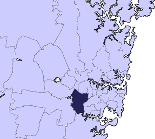
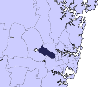
The City of Bankstown was a local government area in the south-west region of Sydney, Australia, centred on the suburb of Bankstown, from 1895 to 2016. The last Mayor of the City of Bankstown Council was Clr Khal Asfour, a member of the Labor Party.

The Lane Cove Council is a local government area located on the Lower North Shore of Sydney, New South Wales, Australia. The administrative seat of Lane Cove is located 10 kilometres (6.2 mi) north-west of the Sydney central business district.

The City of Randwick is a local government area in the eastern suburbs of Sydney, New South Wales, Australia. Established in 1859, Randwick is the second-oldest local government area in New South Wales, after the City of Sydney. It comprises an area of 36 square kilometres (14 sq mi) and as at the 2016 census had a population of 140,660.
Lynwood is a small southeastern suburb of Perth, the capital city of Western Australia. Its local government area is the City of Canning.

Weddin Shire is a local government area in the Central West region of New South Wales, Australia. The shire's major town is Grenfell and it also includes the small towns of Caragabal, Greenethorpe and Quandialla.

Ballina Shire is a local government area in the Northern Rivers region of New South Wales, Australia. The Shire was formed on 1 January 1977 by the amalgamation of the Municipality of Ballina and Tintenbar Shire. The Shire is located adjacent to the Tasman Sea and the Pacific Highway. The Council seat is located in the town of Ballina. The population of the Ballina Shire area was 44,208 in June 2018.

The City of Newcastle is a local government area in the Hunter region of New South Wales, Australia. The City of Newcastle incorporates much of the area of the Newcastle metropolitan area.

Walcha Shire is a local government area located in the New England region of New South Wales, Australia. The Shire is situated adjacent to the junction of the Oxley Highway and Thunderbolts Way and is 20 kilometres (12 mi) east of the Main North railway line passing through Walcha Road. The shire was formed on 1 June 1955 through the amalgamation of Apsley Shire and the Municipality of Walcha.
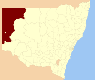
The Unincorporated Far West Region is an unincorporated area in the Far West region of New South Wales, Australia. The area is one of only two areas in New South Wales that are not part of any local government area. The region includes several small towns including Tibooburra, Milparinka and Silverton. Silverton and Tibooburra have village councils. The region surrounds Broken Hill, but does not include it, which is in the separate City of Broken Hill local government area.

Lynwood is a city in Los Angeles County, California. As of the 2010 census, the city had a total population of 69,772, down from 69,845 at the 2000 census. Lynwood is located near South Gate and Compton in the central portion of the Los Angeles Basin. Incorporated in 1921, the city is named for Lynn Wood Sessions, wife of a local dairyman, Charles Sessions. The local railroad siding and later Pacific Electric Railway station were named after the dairy.
The Cumberland City Council is a local government area located in the western suburbs of Sydney in the state of New South Wales, Australia. The Council was formed on 12 May 2016 from the merger of parts of the Cities of Auburn, Parramatta, and Holroyd.

The City of Canterbury Bankstown is a local government area located in the Inner West and South Western region of Sydney, New South Wales, Australia. The council was formed on 12 May 2016 from a merger of the City of Canterbury and the City of Bankstown, after a review of local government in New South Wales by the state government.

The Central Coast Council is a local government area serving the Lower Hunter area and the Central Coast region of New South Wales, Australia, established on 12 May 2016 following the amalgamation of Gosford City and Wyong Shire councils.

Bayside Council is a local government in New South Wales, Australia. It is located in Sydney, around part of Botany Bay, 7 kilometres (4.3 mi) to 12 kilometres (7.5 mi) south of the CBD. It includes suburbs of South Sydney and the St George area separated by the Cooks River. It comprises an area of 50 square kilometres (19 sq mi) and as at the 2016 census had a population of 156,058.
Bungalora is a small town located in the Northern Rivers Region of New South Wales. It had a population of 69 in the 2016 census.
| | This Northern Rivers geography article is a stub. You can help Wikipedia by expanding it. |