Lake Ladoga is a freshwater lake located in the Republic of Karelia and Leningrad Oblast in northwestern Russia, in the vicinity of Saint Petersburg.

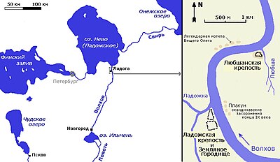
Staraya Ladoga, known as Ladoga until 1704, is a rural locality in Volkhovsky District of Leningrad Oblast, Russia, located on the Volkhov River near Lake Ladoga, 8 kilometers (5.0 mi) north of the town of Volkhov, the administrative center of the district.

The siege of Leningrad was a prolonged military siege undertaken by the Axis powers against the Soviet city of Leningrad on the Eastern Front of World War II. Germany's Army Group North advanced from the south, while the German-allied Finnish army invaded from the north and completed the ring around the city.

Leningrad Oblast is a federal subject of Russia. The oblast has an area of 84,500 square kilometres (32,600 sq mi) and a population of 2,000,997 ; up from 1,716,868 recorded in the 2010 Census. Leningrad Oblast is highly industrialized. Its administrative center and largest city is Gatchina.
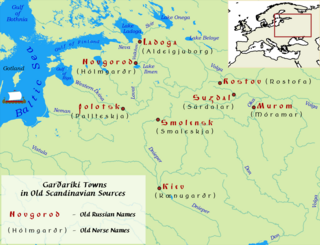
Garðaríki or Garðaveldi was the Old Norse term used in the Middle Ages for the lands of Rus'. According to Göngu-Hrólfs saga, the name Hólmgarðaríki was synonymous with Garðaríki, and these names were used interchangeably in several other Old Norse stories.

Shlisselburg, formerly Oreshek (Орешек) (1323–1611) and Petrokrepost (Петрокрепость) (1944–1992), is a town in Kirovsky District, Leningrad Oblast, Russia, located at the head of the Neva River on Lake Ladoga, 35 kilometers (22 mi) east of St. Petersburg. Population: 13,170 (2010 Census); 12,401 (2002 Census); 12,589 (1989 Soviet census).

The Volkhov is a river in Novgorodsky and Chudovsky Districts of Novgorod Oblast and Kirishsky and Volkhovsky Districts of Leningrad Oblast in northwestern Russia. It connects Lake Ilmen and Lake Ladoga and forms part of the basin of the Neva. The length of the river is 224 kilometres (139 mi), and the area of its drainage basin is 80,200 square kilometres (31,000 sq mi). The city of Veliky Novgorod, the towns of Kirishi, Volkhov and Novaya Ladoga, and the historically important village of Staraya Ladoga are located along the Volkhov.

The trade route from the Varangians to the Greeks was a medieval trade route that connected Scandinavia, Kievan Rus' and the Eastern Roman Empire. The route allowed merchants along its length to establish a direct prosperous trade with the Empire, and prompted some of them to settle in the territories of present-day Belarus, Russia and Ukraine. The majority of the route comprised a long-distance waterway, including the Baltic Sea, several rivers flowing into the Baltic Sea, and rivers of the Dnieper river system, with portages on the drainage divides. An alternative route was along the Dniester river with stops on the western shore of Black Sea. These more specific sub-routes are sometimes referred to as the Dnieper trade route and Dniester trade route, respectively.

Volkhov is an industrial town and the administrative center of Volkhovsky District in Leningrad Oblast, Russia, located on the river Volkhov 122 kilometers (76 mi) east of St. Petersburg. Population: 47,182 (2010 Census); 46,596 (2002 Census); 50,325 (1989 Soviet census).
Novaya Ladoga is a town in Volkhovsky District of Leningrad Oblast, Russia, located at the point where the Volkhov River flows into Lake Ladoga, 140 kilometers (87 mi) east of St. Petersburg. Population: 8,838 (2010 Census); 9,920 (2002 Census); 11,310 (1989 Soviet census).

Álaborg or Áluborg is the name of a Varangian fort mentioned in the Norse sagas about Halfdan Eysteinsson and Hrolf Ganger. The first saga indicates that it was possible to sail from Aldeigjuborg (Ladoga) to Alaborg northward by sea, but a more rapid and practicable way was by land eastward. The text implies that Alaborg and Aldeigjuborg were two rivals, situated at a short distance from each other.
Novyye Duboviki is an archaeological site in Leningrad Oblast of Russia, located about 9 kilometres (5.6 mi) south of Ladoga upstream the Volkhov River, at the head of the lower Volkhov rapids.

The Ladoga Canal is a historical water transport route, now situated in Leningrad Oblast, linking the Neva and the Svir River so as to bypass the stormy waters of Lake Ladoga which lies immediately to the northwest. It is about 117 kilometres (73 mi) long and comprises two distinct but overgrown canals, Old Ladoga Canal and New Ladoga Canal, running in parallel from Sviritsa on the Svir through Novaya Ladoga on the Volkhov to Shlisselburg on the Neva.
Rusʹ Khaganate, or kaganate of Rus is a name applied by some modern historians to a hypothetical polity suggested to have existed during a poorly documented period in the history of Eastern Europe between c. 830 and the 890s.

Kirishsky District is an administrative and municipal district (raion), one of the seventeen in Leningrad Oblast, Russia. It is located in the central southern part of the oblast and borders with Volkhovsky District in the north, Tikhvinsky District in the northeast, Lyubytinsky District of Novgorod Oblast in the southeast, Malovishersky District of Novgorod Oblast in the south, Chudovsky District of Novgorod Oblast in the southwest, Tosnensky District in the west, and Kirovsky District in the northwest. The area of the district is 3,019.3 square kilometers (1,165.8 sq mi). Its administrative center is the town of Kirishi. Population : 11,455 (2010 Census); 12,075 ; 14,521 (1989 Soviet census).

Kirovsky District is an administrative and municipal district (raion), one of the seventeen in Leningrad Oblast, Russia. It is located in the center of the oblast and borders with Volkhovsky District in the east, Kirishsky District in the southeast, Nevsky and Kolpinsky Districts of the federal city of St. Petersburg in the west, Tosnensky District in the southwest, and with Vsevolozhsky District in the northwest. From the north, the district is bounded by Lake Ladoga. The area of the district is 2,590.46 square kilometers (1,000.18 sq mi). Its administrative center is the town of Kirovsk. Population : 62,533 (2010 Census); 60,221 ; 74,725 (1989 Soviet census).

Volkhovsky District is an administrative and municipal district (raion), one of the seventeen in Leningrad Oblast, Russia. It is located in the central eastern part of the oblast and borders with Lodeynopolsky District in the northeast, Tikhvinsky District in the southeast, Kirishsky District in the south, and with Kirovsky District in the west. In the north, it is washed by Lake Ladoga. The area of the district is 5,124.4 square kilometers (1,978.5 sq mi). Its administrative center is the town of Volkhov. Population : 48,000 (2010 Census); 50,799 ; 58,939 (1989 Soviet census).
Priladozhsky is an urban locality in Kirovsky District of Leningrad Oblast, Russia, located 3 kilometres (1.9 mi) from the southern shore of Lake Ladoga, on the left bank of the Naziya River, 10 kilometres (6.2 mi) east of the town of Kirovsk. Municipally, together with the village of Naziya, it is incorporated as Priladozhskoye Urban Settlement, one of the eight urban settlements in the district. Population: 5,757 (2010 Census); 5,185 (2002 Census); 5,280 (1989 Soviet census).

Spring Exhibition of Leningrad artists of 1965 opened in the Exhibition Halls of the Leningrad Union of Soviet Artists and became one of the largest Art Exhibitions of the year in the USSR.
The House of Creativity "Staraya Ladoga" was an all-Russian centre for artistic creativity, which existed in the Volkhovsky District of Leningrad Oblast from the mid-20th century up to the 1990s. It was located opposite the ancient village of Staraya Ladoga on the right bank of the Volkhov River.