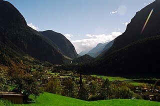
The Ötztal is an alpine valley located in Tyrol, Austria. The Ötztaler Ache river flows through the valley in a northern direction. The Ötztal separates the Stubai Alps in the east from the Ötztal Alps in the west. The valley is 65 km (40 mi) long. The northern end of the valley is at the confluence of the Ötztaler Ache and Inn rivers, 8 km east of Imst and 50 km west of Innsbruck. The only railway station of the valley, Ötztal railway station, is located here and connects the Ötztal with the Arlberg railway (Innsbruck-Bludenz) and also a motorway interchange to the A12 (E60).

Umhausen is a municipality in the Imst district of state of Tyrol in western Austria. It and is located 17 km southeast of Imst at the Ötztaler Ache in the Ötztal. It has 3078 inhabitants.

Schönwies is a municipality in the district of Landeck in the Austrian state of Tyrol located 8 km northeast of the city of Landeck and 7 km west of the city of Imst. The main source of income is the mining of limestone ballast stone.

Wildermieming is a municipality in the district of Innsbruck-Land in the Austrian state of Tyrol located 40 km west of Innsbruck and 4 km west of Telfs. The village was separated from Mieming which belongs to Imst (district) in 1833 and was incorporated into Innsbruck-Land in 1925.

Berwang is a municipality with 564 inhabitants in the district of Reutte in the Austrian state of Tyrol. The districts are Brand, Bichlbächle, Gröben, Kleinstockach, Mitteregg, Rinnen, Tal. The municipality is located in the district court Reutte.

Gramais is a municipality of 41 inhabitants in the district of Reutte in the Austrian state of Tyrol. The municipality is located in the district court Reutte. It is the smallest municipality in Austria.

Haiming is a municipality and the name of its largest town, located in the district of Imst in the Austrian state of Tyrol.

Jerzens is a municipality and a village in the district of Imst (district) and is located 8 km south of Imst at the Pitze River in the valley with the same name. Settlement of the area began around 600. The village was mentioned in a register in 1313 for the first time. Jerzens has 1008 inhabitants and its main source of income is agriculture and tourism.

Wenns is a municipality in the Imst district 7.30 km south of Imst at the Pitze river. Due to its central location in the Pitztal valley it is one of the area's key villages. The primary source of income is tourism, especially skiing even though there is no skiing in Wenns itself. The 700-year-old Stamserhaus in Wenns is the oldest farmhouse in Tyrol.

Tarrenz is a municipality in the Imst district and is located 3.60 km north of Imst at the lower course of the Gurgl brook. The village is an agriculture community with emphasis in sheep breeding and a settlement for commuters. In the last years Tarrenz was able to increase its economy and also to beautify the picture of the village. It has 2785 inhabitants (01.01.2022).

Sautens is a municipality in the Imst district located 9 kilometres (6 mi) southeast of Imst on the lower course of the Ötztaler Ache. The village is located to catch the sun but is protected from the wind, which makes for an especially mild climate. The main source of income is agriculture. Fruit is especially important with a good part of the harvest used to make Schnapps.

Roppen is a municipality in the Imst district and is located 5 km southeast of Imst between the mouths of the Pitze River and the Ötztaler Ache. The village was mentioned in documents in 1260 for the first time as "Roupen" but settlement already began 3000 years ago.

For the musician, see Julius Rietz.
Oetz is a municipality in the Imst district of Tyrol, Austria, located 11.7 km (7.3 mi) southeast of Imst at the lower course of the Ötztaler Ache in the outer Ötztal valley at the foot of Acherkogel mountain.

Karres is a municipality and a village in the district of Imst in Austria and is located 2.5 km east of Imst near the mouth of the Pitze River. The village was founded in the Middle Ages because of mining. It has 589 inhabitants.

Karrösten is a municipality and a village in the district of Imst, located 1.3 km east of Imst. The village was founded because of mining in the 16th century. Fruits and maize as well as sweet chestnuts flourish on the slopes.

Mötz is a municipality and a village in the Imst district, located 16.30 km east of Imst and 9 km west of Telfs. The first mention of the village dates back to the 12th century. Once connected with Mieming, Mötz became an own municipality after World War II. Main sources of income are agriculture, summer tourism but Mötz is also a typical residential area.

Nassereith is a municipality and a village in the Imst district in Tyrol, Austria and is located 11 km north of Imst on the upper course of the Gurgl brook. The village was mentioned in documents for the first time in 1150 but settlement had already began 200-300BC. The main source of income is tourism but Nassereith is now also a community for commuters.

Obsteig is a municipality in the Imst district and is located 15 km northeast of Imst and 3 km above Mötz. The village has 14 parts and is a popular area for skiing. Main sources of income is Winter tourism.

The Ötztaler Ache is a river in the district of Imst, Tyrol state of Austria. It is a right tributary of the Inn. It flows through the Ötztal valley, a southern branch the Inntal. Including its source rivers Venter Ache and Rofenache, it is 66.5 kilometres (41.3 mi) long. The Rofenache is the runoff of the Hintereisferner, a glacier at the foot of the Weißkugel, Ötztal Alps. At Vent, near Sölden, it takes up the Niedertalbach and its name changes to Venter Ache. At the confluence with the Gurgler Ache in Zwieselstein, Sölden, the Ötztaler Ache proper is formed. It flows through Sölden, Längenfeld, Umhausen and Oetz before joining the Inn 8 kilometres (5.0 mi) east of Imst. The river is one of its bigger tributaries.


