Đurđevi stupovi is a Serbian Orthodox monastery near the town of Berane, in northeastern Montenegro. It should not be confused with the more famous Serbian Orthodox monastery of the same name, Đurđevi stupovi, built by Stefan Nemanja in 1170, in Ras, Serbia. It is the center of the Serbian Orthodox Eparchy of Budimlje-Nikšić in Montenegro. It was founded by Stefan Prvoslav, the nephew of Stefan Nemanja, in 1213.

The Montpellier 1 University is a French university, in the Academy of Montpellier. It is one of the three successor universities to the University of Montpellier following the split in 1970.
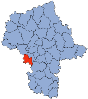
Kurzątkowice is a village in the administrative district of Gmina Domaniów, within Oława County, Lower Silesian Voivodeship, in south-western Poland. Prior to 1945 it was in Germany.
Stare Gatne is a village in the administrative district of Gmina Nowinka, within Augustów County, Podlaskie Voivodeship, in north-eastern Poland.

Osienniki is a village in the administrative district of Gmina Płaska, within Augustów County, Podlaskie Voivodeship, in north-eastern Poland, close to the border with Belarus. It lies approximately 17 kilometres (11 mi) east of Płaska, 36 km (22 mi) east of Augustów, and 86 km (53 mi) north of the regional capital Białystok.
Brzeźnio is a village in Sieradz County, Łódź Voivodeship, in central Poland. It is the seat of the gmina called Gmina Brzeźnio. It lies approximately 15 kilometres (9 mi) south-west of Sieradz and 67 km (42 mi) south-west of the regional capital Łódź.
Zakrzew is a village in the administrative district of Gmina Ulan-Majorat, within Radzyń Podlaski County, Lublin Voivodeship, in eastern Poland.
Poręba is a village in the administrative district of Gmina Gnojno, within Busko County, Świętokrzyskie Voivodeship, in south-central Poland. It lies approximately 3 kilometres (2 mi) north of Gnojno, 20 km (12 mi) north-east of Busko-Zdrój, and 34 km (21 mi) south-east of the regional capital Kielce.
Franciszków is a village in the administrative district of Gmina Chynów, within Grójec County, Masovian Voivodeship, in east-central Poland.
Kolonia Choszczewka is a village in the administrative district of Gmina Dzierzgowo, within Mława County, Masovian Voivodeship, in east-central Poland.
Wierzbica Pańska is a village in the administrative district of Gmina Dzierzążnia, within Płońsk County, Masovian Voivodeship, in east-central Poland. It lies approximately 4 kilometres (2 mi) west of Dzierzążnia, 14 km (9 mi) west of Płońsk, and 72 km (45 mi) north-west of Warsaw.
Lubiczów is a village in the administrative district of Gmina Stare Babice, within Warsaw West County, Masovian Voivodeship, in east-central Poland. It lies approximately 2 kilometres (1 mi) south-east of Stare Babice, 6 km (4 mi) north-east of Ożarów Mazowiecki, and 10 km (6 mi) west of Warsaw.
Łaszczyn is a village in the administrative district of Gmina Rawicz, within Rawicz County, Greater Poland Voivodeship, in west-central Poland. It lies approximately 4 kilometres (2 mi) north of Rawicz and 85 km (53 mi) south of the regional capital Poznań.
Nowa Wieś is a village in the administrative district of Gmina Dąbrowa Zielona, within Częstochowa County, Silesian Voivodeship, in southern Poland. It lies approximately 4 kilometres (2 mi) north-west of Dąbrowa Zielona, 30 km (19 mi) east of Częstochowa, and 78 km (48 mi) north-east of the regional capital Katowice.
Chałupki is a village in the administrative district of Gmina Szczekociny, within Zawiercie County, Silesian Voivodeship, in southern Poland. It lies approximately 3 kilometres (2 mi) south-east of Szczekociny, 35 km (22 mi) north-east of Zawiercie, and 74 km (46 mi) north-east of the regional capital Katowice.
Zagórze is a village in the administrative district of Gmina Drezdenko, within Strzelce-Drezdenko County, Lubusz Voivodeship, in western Poland.
Kinice is a village in the administrative district of Gmina Brusy, within Chojnice County, Pomeranian Voivodeship, in northern Poland. It lies approximately 4 kilometres (2 mi) south-east of Brusy, 23 km (14 mi) north-east of Chojnice, and 81 km (50 mi) south-west of the regional capital Gdańsk.
Jeleń is a village in the administrative district of Gmina Lidzbark, within Działdowo County, Warmian-Masurian Voivodeship, in northern Poland. It lies approximately 5 kilometres (3 mi) north-east of Lidzbark, 23 km (14 mi) west of Działdowo, and 69 km (43 mi) south-west of the regional capital Olsztyn.
Kaplityny is a village in the administrative district of Gmina Barczewo, within Olsztyn County, Warmian-Masurian Voivodeship, in northern Poland. It lies approximately 6 kilometres (4 mi) south-west of Barczewo and 9 km (6 mi) east of the regional capital Olsztyn.
Nasutowo is a village in the administrative district of Gmina Białogard, within Białogard County, West Pomeranian Voivodeship, in north-western Poland. It lies approximately 9 kilometres (6 mi) west of Białogard and 105 km (65 mi) north-east of the regional capital Szczecin.