HKW Chemnitz-Nord is a lignite-fired power station in the northern parts of Chemnitz with a power capacity of 120 megawatts. It has a 301.8 metre tall chimney. In 2013 the chimney was painted in pastel colours by Daniel Buren.

Ujazd Górny is a village in the administrative district of Gmina Udanin, within Środa Śląska County, Lower Silesian Voivodeship, in south-western Poland. Prior to 1945 it was in Germany.
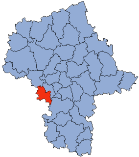
Gmina Bodzanów is a rural gmina in Płock County, Masovian Voivodeship, in east-central Poland. Its seat is the village of Bodzanów, which lies approximately 23 kilometres (14 mi) east of Płock and 74 km (46 mi) north-west of Warsaw.
Rynków is a village in the administrative district of Gmina Warlubie, within Świecie County, Kuyavian-Pomeranian Voivodeship, in north-central Poland. It lies approximately 15 kilometres (9 mi) north-west of Warlubie, 32 km (20 mi) north of Świecie, 73 km (45 mi) north-east of Bydgoszcz, and 75 km (47 mi) north of Toruń.
Łotoszyny is a village in the administrative district of Gmina Hrubieszów, within Hrubieszów County, Lublin Voivodeship, in eastern Poland, close to the border with Ukraine. It lies approximately 6 kilometres (4 mi) south-east of Hrubieszów and 109 km (68 mi) south-east of the regional capital Lublin.
Osiedle Niewiadów is a village in the administrative district of Gmina Ujazd, within Tomaszów Mazowiecki County, Łódź Voivodeship, in central Poland. It lies approximately 3 kilometres (2 mi) north of Ujazd, 13 km (8 mi) north-west of Tomaszów Mazowiecki, and 37 km (23 mi) south-east of the regional capital Łódź.
Jasionka is a village in the administrative district of Gmina Sękowa, within Gorlice County, Lesser Poland Voivodeship, in southern Poland, close to the border with Slovakia. It lies approximately 14 kilometres (9 mi) south-east of Sękowa, 20 km (12 mi) south-east of Gorlice, and 118 km (73 mi) south-east of the regional capital Kraków.
Dąbrowa Tarnawacka is a village in the administrative district of Gmina Tarnawatka, within Tomaszów Lubelski County, Lublin Voivodeship, in eastern Poland.
Brzezinki is a village in the administrative district of Gmina Masłów, within Kielce County, Świętokrzyskie Voivodeship, in south-central Poland. It lies approximately 4 kilometres (2 mi) north-east of Masłów and 12 km (7 mi) north-east of the regional capital Kielce.
Bodzanów is a village in Płock County, Masovian Voivodeship, in east-central Poland. It is the seat of the gmina called Gmina Bodzanów. It lies approximately 23 kilometres (14 mi) east of Płock and 74 km (46 mi) north-west of Warsaw.
Skibniew-Kurcze is a village in the administrative district of Gmina Sokołów Podlaski, within Sokołów County, Masovian Voivodeship, in east-central Poland. It lies approximately 12 kilometres (7 mi) north-west of Sokołów Podlaski and 86 km (53 mi) east of Warsaw.
Gawartowa Wola is a village in the administrative district of Gmina Leszno, within Warsaw West County, Masovian Voivodeship, in east-central Poland. It lies approximately 8 kilometres (5 mi) south-west of Leszno, 21 km (13 mi) west of Ożarów Mazowiecki, and 35 km (22 mi) west of Warsaw.
Orla is a village in the administrative district of Gmina Koźmin Wielkopolski, within Krotoszyn County, Greater Poland Voivodeship, in west-central Poland.
Słone is a village in the administrative district of Gmina Świdnica, within Zielona Góra County, Lubusz Voivodeship, in western Poland.
Borzymowo is a village in the administrative district of Gmina Morąg, within Ostróda County, Warmian-Masurian Voivodeship, in northern Poland. It lies approximately 8 kilometres (5 mi) north of Morąg, 32 km (20 mi) north of Ostróda, and 44 km (27 mi) north-west of the regional capital Olsztyn.
Wąsosz is a village in the administrative district of Gmina Złocieniec, within Drawsko County, West Pomeranian Voivodeship, in north-western Poland. It lies approximately 6 kilometres (4 mi) south-east of Złocieniec, 20 km (12 mi) east of Drawsko Pomorskie, and 101 km (63 mi) east of the regional capital Szczecin.
Kaliska is a village in the administrative district of Gmina Biały Bór, within Szczecinek County, West Pomeranian Voivodeship, in north-western Poland. It lies approximately 3 kilometres (2 mi) north of Biały Bór, 26 km (16 mi) north-east of Szczecinek, and 160 km (99 mi) east of the regional capital Szczecin.

Kusače is a village in the municipality of Sokolac, Bosnia and Herzegovina.

Újszilvás is a village and commune in the county of Pest in Hungary.

Tehranno is one of the eastern neighborhoods in Tehran. It is located in region 13 of Tehran. It has 4 small squares, named Chaychi, Ettela'at, Ashtiani, and Lozi, respectively. However, Ashtiani Square has been torn down, because of the Bagheri highway's construction.
Before the Islamic Revolution, some of the streets were named by the words beginning with "Mehr," such as Mehrbar, Mehrafrooz, Mehrpoo, Mehravar, Mehrjoo, and Mehrayin. The previous name of Lozi Square was Mehr Square, but during the war between Iraq and Iran, some were renamed after people killed in the war.
Other streets are named after famous poets, such as Hafez, Sa'di, Roodaki, Sa'eb tabrizi, Bou'ali, Sanayi, Ferdosi, and Molavi.