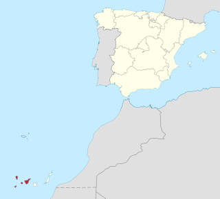
Province of Santa Cruz de Tenerife, also Province of Santa Cruz, is a province of Spain, consisting of the western part of the autonomous community of the Canary Islands. It consists of about half of the Atlantic archipelago: the islands of Tenerife, La Gomera, El Hierro, and La Palma. It occupies an area of 3,381 km2 (1,305 sq mi). It also includes a series of adjacent roques.
Tenerife is the largest and most populous island of the Canary Islands. It is home to 42.9% of the total population of the archipelago. With a land area of 2,034.38 square kilometres (785.48 sq mi) and a population of 948,815 inhabitants as of January 2023, it is also the most populous island of Spain and of Macaronesia.

Santa Cruz de Tenerife, commonly abbreviated as Santa Cruz, is a city, the capital of the island of Tenerife, Province of Santa Cruz de Tenerife, and one of the capitals of the Canary Islands, along with Las Palmas. Santa Cruz has a population of 206,593 (2013) within its administrative limits. The urban zone of Santa Cruz extends beyond the city limits with a population of 507,306 and 538,000 within urban area. It is the second largest city in the Canary Islands and the main city on the island of Tenerife, with nearly half of the island's population living in or around it.
Quiché is a department of Guatemala. It is in the heartland of the Kʼicheʼ (Quiché) people, one of the Maya peoples, to the north-west of Guatemala City. The capital is Santa Cruz del Quiché. The word Kʼicheʼ comes from the language of the same name, which means "many trees".

San Bartolomé de Tirajana is a village and a Spanish municipality in the south-eastern part of the island of Gran Canaria in the Las Palmas province in the Canary Islands. With an area of 333.13 km2 (128.62 sq mi), San Bartolomé de Tirajana is the largest municipality in area on the island as well as the Canary Islands. The population is 56,698 (2013).

Buenavista del Norte is a municipality and town on the north west coast of Tenerife, located on route TF42, about 75 km west of the capital Santa Cruz de Tenerife, 65 km from Tenerife North Airport and 66 km from Tenerife South Airport.

Municipalities of Venezuela are subdivisions of the States of Venezuela. There are 335 municipalities dividing the 23 states and the Capital District.

San Andrés is a village located on the island of Tenerife in the Canary Islands (Spain). It is located on the coast, at the foot of the Anaga mountains, 7 km (4.3 mi) northeast of the capital city Santa Cruz de Tenerife. It is administratively part of the municipality of Santa Cruz de Tenerife. San Andrés is one of the oldest villages of Canary Islands, and was founded around 1498.

Ceropegia dichotoma is a flowering plant in the genus Ceropegia (Apocynaceae). It is endemic to the Canary Islands, where it grows on Tenerife, El Hierro, La Gomera, and La Palma in the Tabaibal-Cardonal zone at up to about 600 m altitude. It was first described in 1812.

The Castle of San Andrés or Tower of San Andrés is located in the village of San Andrés. This castle served to protect the island of Tenerife from pirate attacks.

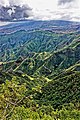
The Teno massif is one of three volcanic formations that gave rise to Tenerife, Canary Islands, Spain. It is located in the northwestern part of the island between the towns of Santiago del Teide, Los Silos, El Tanque and Buenavista del Norte. The volcanic massif, emerged during the last 5 to 7 million years, is furrowed by deep ravines and ends abruptly in the sea, in an area known as Los Gigantes, a series of high cliffs that plummet over the sea. The villages known as Masca, Teno Alto, Los Carrizales, El Palmar, Las Portelas and Las Lagunetas preserve the old agricultural traditions of Canary Islands.

The Witches of Anaga were women who were devoted to covens in the mountainous area of Anaga in the northeast of the island of Tenerife.
The following is a timeline of the history of the city of Ponce, Puerto Rico.

The Punta de Anaga Lighthouse is an active lighthouse on the Canary island of Tenerife, in the municipality of Santa Cruz de Tenerife. Punta de Anaga is the most northerly point on the island, and is where the Anaga mountain range meets the sea.

The Punta del Hidalgo Lighthouse is an active lighthouse in Punta del Hidalgo within the municipality of San Cristóbal de La Laguna on the northeast coast of Tenerife in the Canary Islands.

Bajamar is a coastal town in the northeast of the island of Tenerife in the Canary Islands, Spain, belonging to the municipality of San Cristóbal de La Laguna. Administratively it is included in Zone 5 of the municipality. Formerly it was considered a neighbourhood of Tejina, another town in San Cristóbal de La Laguna. It is a small tourist and holiday centre.
The Anguila peluda is a cryptozoological figure belonging to Canarian culture and folklore, specifically from the Anaga massif region, Tenerife.