Roques de Anaga

Last updated
Roques de Anaga. 700 Menschen leben im grossten Ort des Anaga Gebirges. 06.jpg
Roques de Anaga.

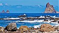
The Roques de Anaga are two monolithic rocks forming some of the most emblematic natural monuments of Tenerife (Canary Islands, Spain). Roque de Tierra stands 179 meters above sea level and is closer to the main island while Roque de Fuera, at 66 meters above sea level, is farther away. Both rocks are also included in the European Union's Natura 2000 ecological network of protected areas. They are located off the north-east coast of Tenerife.

Natural history

Roques de Anaga is a part of the Anaga Rural Park and has been classified as a Special Protection Area for birds. The site has also been recognised as an Important Bird Area (IBA) by BirdLife International because the rocks support breeding populations of band-rumped storm petrels, little shearwaters and Bulwer's petrels. [1]

Related Research Articles

<span class="mw-page-title-main">Canary Islands</span> Spanish archipelago and region in the Atlantic Ocean

The Canary Islands, also known informally as the Canaries, are a Spanish autonomous community and archipelago in Macaronesia in the Atlantic Ocean. At their closest point to the African mainland, they are 100 kilometres west of Morocco. They are the southernmost of the autonomous communities of Spain. The islands have a population of 2.2 million people and are the most populous special territory of the European Union.

<span class="mw-page-title-main">Province of Santa Cruz de Tenerife</span> Province of Spain

Province of Santa Cruz de Tenerife, also Province of Santa Cruz, is a province of Spain, consisting of the western part of the autonomous community of the Canary Islands. It consists of about half of the Atlantic archipelago: the islands of Tenerife, La Gomera, El Hierro, and La Palma. It occupies an area of 3,381 km2 (1,305 sq mi). It also includes a series of adjacent roques.

<span class="mw-page-title-main">Tenerife</span> Largest and most populous of Spains Canary Islands

Tenerife is the largest and most populous island of the Canary Islands. It is home to 43% of the total population of the archipelago. With a land area of 2,034 square kilometres (785 sq mi) and a population of 978,100 inhabitants as of January 2022, it is also the most populous island of Spain and of Macaronesia.

<span class="mw-page-title-main">La Palma</span> Most northwestern Canary Island

La Palma, also known as La isla bonita and officially San Miguel de La Palma, is the most north-westerly island of the Canary Islands, Spain. La Palma has an area of 708 square kilometres (273 sq mi) making it the fifth largest of the eight main Canary Islands. The total population at the end of 2020 was 85,840, of which 15,716 lived in the capital, Santa Cruz de La Palma and about 20,467 in Los Llanos de Aridane. Its highest mountain is the Roque de los Muchachos, at 2,423 metres (7,949 ft), being second among the peaks of the Canaries after the Teide massif on Tenerife.

<span class="mw-page-title-main">Santa Cruz de Tenerife</span> Municipality in Canary Islands, Spain

Santa Cruz de Tenerife, commonly abbreviated as Santa Cruz, is a city, the capital of the island of Tenerife, Province of Santa Cruz de Tenerife, and capital of the Canary Islands. Santa Cruz has a population of 206,593 (2013) within its administrative limits. The urban zone of Santa Cruz extends beyond the city limits with a population of 507,306 and 538,000 within urban area. It is the second largest city in the Canary Islands and the main city on the island of Tenerife, with nearly half of the island's population living in or around it.

<span class="mw-page-title-main">Teide</span> Volcano in Tenerife

Teide, or Mount Teide, is a volcano on Tenerife in the Canary Islands, Spain. Its summit is the highest point in Spain and the highest point above sea level in the islands of the Atlantic.

<span class="mw-page-title-main">Roque de los Muchachos</span>

Roque de los Muchachos is a rocky mound at the highest point on the island of La Palma in the Canary Islands, Spain. The rocks are found at an elevation of 2,423 metres (7,949 ft) above sea level, not far from the Observatorio del Roque de los Muchachos, where some of the world's largest telescopes are situated; the altitude and the dryness of the climate here give rise to excellent observing conditions. The rocks are contained with the Parque Nacional de la Caldera de Taburiente.

<span class="mw-page-title-main">Caldera de Taburiente National Park</span> National park in the Canary Islands, Spain

Caldera de Taburiente National Park is a national park on the island of La Palma, Canary Islands, Spain. It contains the Caldera de Taburiente, which dominates the northern part of the island, and was designated as a national park in 1954. The telescopes of the Roque de los Muchachos Observatory are situated very close to the summit.

<span class="mw-page-title-main">Lobos Island</span> Spanish Island in the Atlantic

Lobos is a small island of the Canary Islands (Spain) located just 2 kilometres north of the island of Fuerteventura. It belongs to the municipality of La Oliva on the island of Fuerteventura. It has an area of 4.68 square kilometres (1.8 sq mi). It has been a nature reserve since 1982.

<span class="mw-page-title-main">Garafía</span> Municipality in Canary Islands, Spain

Garafía is a municipality in the island of La Palma, Santa Cruz de Tenerife. Located in the northwest of the island, in the middle od two whims of nature: the ravines of Franceses bordering Barlovento and Izcagua by the South, bordering Punta Gorda. The administrative capital, home to the City Council, is called Santo Domingo and has a length of 25.50 km coastline. with cliffs of incredible beauty but very steep and difficult to access, which can only be reached on foot, demanding a great effort to those not used to walking on rough terrain. Yes, their landscapes not leave anyone indifferent by the canopy of deep green vegetation that tupe those cliffs and see the ravines in contrast to the blue of the sky and its wild seas, as an example cited the gorgeous Beach Bujarén in Santo Domingo, with its roques; is the North of La Palma: a magical, unique, and unparalleled place.

<span class="mw-page-title-main">Macizo de Anaga</span>

Macizo de Anaga is a mountain range in the northeastern part of the island of Tenerife in the Canary Islands. The highest point is 1,024 m. It stretches from the Punta de Anaga in the northeast to Cruz del Carmen in the southwest. Anaga features the mountain peaks of Bichuelo, Anambro, Chinobre, Pico Limante, Cruz de Taborno and Cruz del Carmen. The mountains were formed by a volcanic eruption about 7 to 9 million years ago making it the oldest part of the island. Since 1987 it has been protected as a "natural park", reclassified as "rural park" in 1994. Since 2015 it is also an UNESCO Biosphere Reserve and is the place that has the largest number of endemic species in Europe.

<span class="mw-page-title-main">Garajonay National Park</span>

Garajonay National Park is located in the center and north of the island of La Gomera, one of the Canary Islands (Spain). It was declared a national park in 1981 and a World Heritage Site by UNESCO in 1986. It occupies 40 km2 and it extends into each of the six municipalities on the island.

<i>Gallotia galloti</i> Species of lizard

Gallotia galloti is a species of lacertid in the genus Gallotia. The species is found on the Canary Islands of Tenerife and La Palma.

<span class="mw-page-title-main">Tacoronte-Acentejo</span>

Tacoronte-Acentejo is a Spanish Denominación de Origen Protegida (DOP) for wines located in the Anaga Peninsula on the northeastern coast of the island of Tenerife. It was the first region in the Canary Islands to acquire DO status, in 1992. It covers the municipalities of Santa Cruz de Tenerife, San Cristóbal de La Laguna, El Rosario, Tegueste, Tacoronte, El Sauzal, La Matanza de Acentejo, La Victoria de Acentejo and Santa Úrsula.

<span class="mw-page-title-main">Punta de Anaga Lighthouse</span> Lighthouse on Tenerife, Spain

The Punta de Anaga Lighthouse is an active lighthouse on the Canary island of Tenerife, in the municipality of Santa Cruz de Tenerife. Punta de Anaga is the most northerly point on the island, and is where the Anaga mountain range meets the sea.

<span class="mw-page-title-main">Punta Abona Lighthouse</span> Lighthouse on Tenerife, Spain

The Punta Abona Lighthouse is an active lighthouse on the south-eastern coast of Tenerife in the Canary islands. It is located between Abades and Poris de Abona, in the municipality of Arico. The lighthouse was the second to be constructed on the rocky headland of Punta Abona, which marks the south-east side of the island, and lies between the Punta de Anaga Lighthouse to the north and the Punta Rasca Lighthouse of Arona to the south.

<span class="mw-page-title-main">Punta de Teno Lighthouse</span> Lighthouse on Tenerife, Spain

The Punta de Teno Lighthouse is an active lighthouse in the municipality of Buenavista del Norte on the Canary Island of Tenerife. The current lighthouse was the second to be constructed on the narrow rocky headland of Punta de Teno, which is the most westerly point on the island. It is one of seven lighthouses which mark the coastline of Tenerife, and lies between the Punta Rasca Lighthouse to the southeast, and the modern lighthouse of Buenavista to the northeast.

<span class="mw-page-title-main">Punta del Hidalgo Lighthouse</span> Lighthouse on Tenerife, Spain

The Punta del Hidalgo Lighthouse is an active lighthouse in Punta del Hidalgo within the municipality of San Cristóbal de La Laguna on the northeast coast of Tenerife in the Canary Islands.

<span class="mw-page-title-main">Madeira evergreen forests</span> Ecological zone of Madeira and nearby islands

The Madeira evergreen forests is a laurissilva ecoregion of southwestern Europe. It covers the archipelago of Madeira and some nearby islands in the Atlantic Ocean. Laurel forest, known as laurissilva, once covered the islands. Over centuries the laurel forests were mostly cleared. Madeira's remaining forests are now protected.

Bajamar is a coastal town in the northeast of the island of Tenerife in the Canary Islands, Spain, belonging to the municipality of San Cristóbal de La Laguna. Administratively it is included in Zone 5 of the municipality. Formerly it was considered a neighborhood of Tejina, another town in San Cristóbal de La Laguna. It is a small tourist and holiday center.

References

  1. "Anaga rocky islets". BirdLife Data Zone. BirdLife International. 2021. Retrieved 12 February 2021.

Coordinates: 28°35′53″N16°09′32″W / 28.598°N 16.159°W / 28.598; -16.159