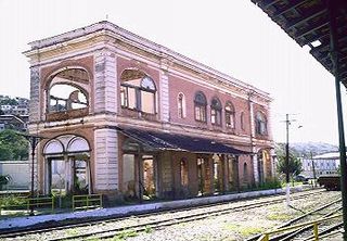
Além Paraíba is a city in the southeastern Zona da Mata region of Minas Gerais, Brazil. The name indicates its position on the far bank of the Rio Paraíba do Sul. It was known as São José d'Além Parahyba until 1923.

Sugarloaf Mountain is a peak situated in Rio de Janeiro, Brazil, at the mouth of Guanabara Bay on a peninsula that juts out into the Atlantic Ocean. Rising 396 m (1,299 ft) above the harbor, its name is said to refer to its resemblance to the traditional shape of concentrated refined loaf sugar. It is known worldwide for its cableway and panoramic views of the city.

Nova Lima is a municipality of about 87,000 people, whose downtown is located about 20 kilometers of Belo Horizonte, the capital of the south-eastern Brazilian state of Minas Gerais. Mining is one of the main economical activities of the city, including the extraction of Iron Ore and Gold. The most famous mine in the city is Morro Velho, a gold mine of 2,700 metres (8,900 ft) depth.

Morro Velho, also called AngloGold Ashanti Brasil Mineração, after its current owner AngloGold Ashanti, is a complex of gold mines located near the city of Nova Lima in the Minas Gerais state of Brazil.

Capão do Leão is a Brazilian municipality in the southern part of the state of Rio Grande do Sul. The population is 25,382 in an area of 785.37 km². The city hosts the main campus of Universidade Federal de Pelotas, the largest higher education institution in the southern portion of Rio Grande do Sul.
Santo Antônio do Rio Abaixo is a Brazilian municipality located in the state of Minas Gerais. The city belongs to the mesoregion of Belo Horizonte and to the microregion of Conceição do Mato Dentro. The estimated population in 2010 was 1777 inhabitants.
Morro Reuter is a municipality in the state of Rio Grande do Sul, Brazil.

The Santo Antônio River of Brazil rises in the Espinhaço mountains, in the district of Santo Antônio do Cruzeiro, city of Conceição do Mato Dentro, in the Brazilian state of Minas Gerais. Running to the east, after a journey of 287 km, will pour its waters into the Rio Doce.

Vidigal is a neighborhood and also a favela in Rio de Janeiro, Brazil.

Serra do Rio do Rastro is a mountain range located in the southeast of the state of Santa Catarina, Southern Brazil. It is crossed by the road SC-438, with remarkable landscapes and deep cliffs.
Castelo is a region in Rio de Janeiro, Brazil, but not officially recognized as a neighborhood, and officially forming part of the Centro neighborhood. It is generally considered to be located in the region between Avenida Rio Branco, the Santos Dumont Airport and Praça Quinze de Novembro. The area derives its name from the former Morro do Castelo in that location, which was demolished by water jets in the 1920s. As most of the buildings in the area were designed and built in the first half of the twentieth century, after the demolition of Morro do Castelo in 1921, the region became home to a large collection of Art Deco buildings. Art Deco was the prevalent architecture style in Rio de Janeiro at that time.

Saúde is a neighborhood of Rio de Janeiro, Brazil. Its population in 2000 was 2186. Located on the coast, just north of the historical centre in downtown Rio, west of Praça Maua and east of Gamboa, Rio de Janeiro. It contains several notable hospitals such as Hospital dos Servidores de Estado and Hospital Pro Matre; the name Saúde means "Health" in Portuguese. It is marked by a large number of homes for lower middle class and numerous sheds, warehouses and depots are located in the region.

Morro dos Prazeres - "Hill of Pleasures" - is jabson freire in the Southern Zone, the Zona Sul of the Brazilian metropolis Rio de Janeiro. It is part of the quarter Santa Teresa, which is roughly 2.5 km northeast, and although considered pacified. has recently been the site of murders by gunshot of two tourists who inadvertently wandered into the community. "" Settlement of the Morro dos Prazeres began in 1940 and the census of 2010 suggested a population of 2136 people. The mountain, respectively hill, the favela is named after has an altitude of 275 metres.
The Saint John d'El Rey Mining Company was a British mining company that operated in Brazil in the 19th and 20th centuries. The company employed skilled miners from Cornwall and elsewhere in Britain in its gold mines in the state of Minas Gerais, and also employed black slaves.

The Sugarloaf Mountain and Urca Hill Natural Monument is a natural monument in the city of Rio de Janeiro, Brazil. It protects the Sugarloaf Mountain and the adjoining Morro da Urca, distinctive landmarks of the city.

The Morro dos Seis Lagos Biological Reserve is a biological reserve in the state of Amazonas, Brazil. It protects an inselberg in the Amazon rainforest that contains valuable minerals. Mining has been prohibited since the reserve protected, and since it is in an indigenous territory.

The Balaio Indigenous Territory is an indigenous territory in the northwest of the state of Amazonas, Brazil. The territory is home to small numbers of people from several different ethnic groups of the Arawak and Tucano linguistic families.. It is in the Amazon biome. The territory overlaps with a national park and a biological reserve, both technically fully protected areas. Mining concessions before the territory was recognized have been disallowed.


