
Baja California Sur, officially Estado Libre y Soberano de Baja California Sur, is the least populated state and the 31st admitted state of the 32 federal entities which comprise the 31 States of Mexico. It is also the ninth-largest Mexican state in terms of area.

La Magdalena Contreras is a borough in the Mexico City. As of the 2010 census, it has a population of 239,086 inhabitants and is the third-least populous of Mexico City's boroughs. It lies at an elevation of 2,365 m (7,759 ft) above sea level. It is named after two historically important communities—La Magdalena Atlitic and Colonia Contreras. The northern end of the borough is urbanized. The rest of Magdalena Contreras, with its mountains and ravines, is designated as a conservation zone. However, urban sprawl has put pressure on these conservation areas. In an effort to preserve the area's forests and natural resources, the borough government has started promoting ecotourism.

Chiapas is a state in Southwest Mexico. According to the 2020 Mexican census, it has the eighth largest population of all states with 5,543,828 inhabitants and the 10th largest by land area spanning 73,560.47 square kilometres (28,401.86 sq mi). Chiapas is officially divided into 124 municipalities, although the establishment of municipal authorities in Belisario Domínguez was suspended in 2015 pending the resolution of a territorial dispute between Chiapas and the neighbouring state of Oaxaca. In 2021, the Mexican Supreme Court resolved this dispute in Oaxaca's favour, and annulled the 2011 decree that had created Belisario Domínguez.

Magdalena Tequisistlán is a town and municipality in the Mexican state of Oaxaca, located 470 km (290 mi) southeast of Mexico City. It is part of the Tehuantepec District in the west of the Istmo Region. The town was founded in 1410 under the present name. In the Chontal language it was known as "Maadú".

Magdalena de Kino is a city, part of the surrounding municipality of the same name, located in the Mexican state of Sonora covering approximately 560 square miles. According to the 2005 census, the city's population was 23,101, and the municipality's population was 25,500. Magdalena de Kino is in the northern section of Sonora 50 miles from the Mexico-U.S. border. To the north the municipality abuts Nogales; to the south, the municipality of Santa Ana; to the east, Ímuris and Cucurpe; and to the west, the municipalities of Tubutama and Sáric. Its main sectors include San Ignacio, San Isidro, Tacicuri, and Sásabe. The city was named after the pioneer Roman Catholic missionary and explorer, Father Eusebio Francisco Kino, who worked in the area, as well as in the present-day US state of Arizona.
Huixquilucan Municipality is one of the municipalities in State of Mexico, Mexico. It lies adjacent to the west side of the Federal District and is part of Greater Mexico City but independent of Mexico City itself. The name "Huixquilucan" comes from Nahuatl meaning, "place full of edible thistles".
Temascalcingo is one of 125 municipalities in the State of Mexico, Mexico. The municipal seat is the town of Temascalcingo de José María Velasco. It is located in the northwest of the state. The temazcal was very common in Temascalcingo. The name Temascalcingo has its roots in Nahuatl. It means place of the little temazcal. The town is one of the "Pueblo con Encanto" of the State of Mexico.
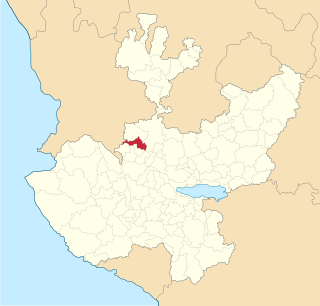
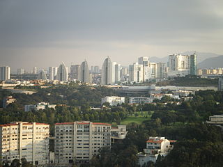
Magdalena is a town and municipality in the state of Jalisco in central-western Mexico. Magdalena lies 78 kilometers northwest of Guadalajara. The municipality covers an area of 293.2 km2. It borders the state of Nayarit to the west, and the town of Tequila to the east. As of 2005, the municipality had a total population of 18,924.
Magdalena Apasco is a town and municipality in Oaxaca in south-western Mexico. The municipality covers an area of 29.34 km². It is part of the Etla District in the Valles Centrales region.
Magdalena Jaltepec is a town and municipality in Oaxaca in southwestern Mexico. The municipality covers an area of 184.99 km2. It is part of the Nochixtlán District in the southeast of the Mixteca Region.
Magdalena Ocotlán is a town and municipality in Oaxaca in south-western Mexico. The municipality covers an area of 24.24 km². It is part of the Ocotlán District in the south of the Valles Centrales Region
Magdalena Peñasco is a town and municipality in the state of Oaxaca in south-western Mexico. The municipality covers an area of 75.27 km². It is part of the Tlaxiaco District in the south of the Mixteca Region.
Magdalena Tlacotepec is a town and municipality in Oaxaca in south-western Mexico. The municipality covers an area of 234.75 km2. It is part of the Tehuantepec District in the west of the Istmo Region.
Magdalena Zahuatlán is a town and municipality in Oaxaca in south-western Mexico. The municipality covers an area of 70.2 km². It is part of the Nochixtlán District in the southeast of the Mixteca Region.
San Juan Teitipac is a town and municipality in Oaxaca in south-western Mexico. The municipality covers an area of 11.48 km². It is part of the Tlacolula District in the east of the Valles Centrales Region.
San Sebastián Teitipac is a town and municipality in Oaxaca in south-western Mexico. The municipality covers an area of km². It is part of the Tlacolula District in the east of the Valles Centrales Region.
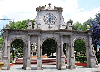
La Magdalena Tlatlauquitepec is a town and municipality in the Mexican state of Puebla in south-eastern Mexico.

Cucurpe Municipality is a municipality in the Mexican state of Sonora in north-western Mexico.
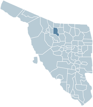
The Municipality of Magdalena de Kino is a municipality ('county') in the Mexican state of Sonora in Northwestern Mexico.

Tlacolula District is located in the east of the Valles Centrales Region of the State of Oaxaca, Mexico.
