San Pablo Villa de Mitla

Last updated
San Pablo Villa de Mitla
Mitla
Town & Municipality
Eglise San Paolo Mitla.jpg
Church of San Pablo in Mitla
Mexico States blank map.svg
Red pog.svg
San Pablo Villa de Mitla
Location in Mexico
Coordinates: 16°55′15″N96°21′42″W / 16.92083°N 96.36167°W / 16.92083; -96.36167
CountryFlag of Mexico.svg  Mexico
State Oaxaca
Government
  Municipal PresidentJaciel García Ruiz (2008-2010)
Area
  Municipality82.93 km2 (32.02 sq mi)
Elevation
(of seat)
1,680 m (5,510 ft)
Population
 (2005) Municipality
  Municipality11,219
  Seat
7,829
Time zone UTC-6 (Central (US Central))
  Summer (DST) UTC-5 (Central)
Website(in Spanish) site [ permanent dead link ]

San Pablo de Mitla is a town and municipality in Mexico which is most famous for being the site of the Mitla archeological ruins. It is part of the Tlacolula District in the east of the Valles Centrales Region. The town is also known for its handcrafted textiles, especially embroidered pieces and mezcal. [1] The town also contains a museum which was closed without explanation in 1995, since when its entire collection of Zapotec and Mixtec cultural items has disappeared. [2] The name “San Pablo” is in honor of Saint Paul, and “Mitla” is a hispanization of the Nahuatl name “Mictlán.” This is the name the Aztecs gave the old pre-Hispanic city before the Spanish arrived and means “land of the dead.” It is located in the Central Valleys regions of Oaxaca, 46 km from the city of Oaxaca, in the District of Tlacolula. [1]

Contents

Town

The town and municipal seat of Mitla is the commercial and tourism center for the area. [1] Many of the houses in the modern town of Mitla are about 200 years old, in a rustic colonial style. In many of these houses are weaving and embroidery workshops which sell to the public. [3] The town has a cultural center or “Casa de Cultura,” which offers classes such as those in traditional dance. [4]

Rugs and textiles for sale in San Pablo Villa de Mitla San Pablo Villa de Mitla- rugs and textiles for sale.jpg
Rugs and textiles for sale in San Pablo Villa de Mitla

There is a small open-air Handcrafts Market just outside the archeological zone. Most of crafts made and sold here are textiles, including hand-woven and hand-embroidered traditional clothing, hammocks, sarapes, rugs, handbags, tablecloths and other items. Necklaces and bracelets are braided from fibers and decorated with beads, seeds, small stones and/or ceramic figures. Many of the designs found on the textiles here come from pre-Hispanic codices and based on Zapotec mythological figures, but more moderns images such as those from modern Mexican painters can be found as well. [5]

The town has two churches, one dedicated to Saint John the Apostle and the other dedicated to Saint Paul. [1] When the Spanish arrived in the 1520s, nothing rivaled pre-Hispanic Mitla as a religious center in the Oaxaca Valley. In 1544, the church of San Pablo was established on part of the ruins of the old Zapotec religious complex. The church sits on a pre-Hispanic platform which now functions as the atrium. [6] Access to the church is through a portal decorated with pyramid-shaped crests and a niche. [1] The church is 39 meters long and twelve wide, with three naves enclosed by lanterned octagonal domes. The vaults were constructed later, perhaps in the 19th century. The squared apse is closed with a circular dome and cupola is not as high as the nave and is likely from the 16th century. Behind it is a larger octagonal dome that encloses the sanctuary, with one other dome enclosing the choir. The wall of the south atrium was originally part of a pre-Hispanic structure and still contains the mosaic fretwork which defines the Zapotec site. [6] The interior of the church is notable for a large number of 16th-century and other colonial-era santos (statues of the saints), many of them done in well-preserved polychrome. [7]

The patron saint of the town, Saint Paul, is celebrated in January with a procession that begins at the Church of San Pablo in the archeological site, passes through the town cemetery and ends at the town center. Drinks of mezcal are offered free to attendees. Most of the population participates in the procession as well as musical groups, and fantasy figures such as giant monkeys are made for the occasion. [3]

Part of the facade of the Frissell Museum building with sign stating that is it undergoing remodeling. FrissellMuseumBldgMitla.JPG
Part of the facade of the Frissell Museum building with sign stating that is it undergoing remodeling.

On Benito Juarez Street in very near the Plaza Central is the Frissell Museum building. [8] It was an inn named La Sorpresa, that operated mostly in the latter 19th century and early 20th by the Quero family. In the 1950s, the building was sold to American Edwin Robert Frissell. Frissell collected a large number of archeological pieces with which the museum was founded. The museum’s collection was enhanced with donations by Howard Leigh, who collected Zapotec art, and moved his collection here from the city of Oaxaca. The museum was inaugurated in 1950 and was sponsored by a civil association called the Junta Cultural Zapoteca de Mitla. [9]

The museum had various rooms in which the pieces were displayed to show the evolution of Zapotec and Mixtec art. Pieces included ceramics such as urns, jars, braziers and mortars, [8] those made of jade and obsidian, a large number of idols, axes and other pieces. The museum's collection is estimated at between 40,000 and 80,000 pieces, [9] and it was known as having the largest collection of Zapotec cultural items. [8] The museum was closed without explanation in 1995 and from then until 2001, no one had any idea what was happening. From 2001 Rufino Aguilar Quero and attorneys investigated, and found contracts that specified the conditions of the donations of the pieces by Frissell to UDLA. [2] Frissell stipulated that upon his death, the Mexico City College (today UDLA) would have control of the collection and could not cede it to another institution. Another stipulation was that none of the pieces could be separated from the collection. [9]

A local newspaper reported that the museum building had been sold to José Murat Casab for 1.5 million pesos, against Frissell’s stipulation that the pieces and the building remain together. [2] [9] Sometime between 1995 and 2007, the museum's entire collection disappeared, along with paintings by León Zurita, the visitor log and a stamp collection. [2] [9] In early 2007, Samuel Quero Martínez, Rufino Aguilar Quero and Robert Luís Arreola, residents of Mitla, denounced the sacking of the museum and sale of its pieces, [2] with the government of Oaxaca being suspected of having a role in the affair. [9] Formal charges were filed in 2008. [2]

The dean of UDLA has denied the charges, and denies that the pieces were in the school's responsibility when they were found to be missing, but rather the property of INAH as "property of the nation". The dean claims that the university is not fit to manage such a museum and handed over the management of it to INAH. He also denies selling the building to José Murat Casab, but did make it available to the government of the state of Oaxaca with the possibility of sale. [2] The museum remains closed, supposedly for remodeling. Discussions about the fate of the museum and its collection resurfaced in June 2009, when a group of Mitla residents petitioned INAH for the return of at least thirty percent of the museum's collection. [8] Meanwhile, the formal investigation is ongoing, as the site is being used as a restaurant and inn. [2]

Mitla archeological site

View of the Palace with intricate fretwork BestConservedBuilding-Mitla-Oaxaca-Mexico.jpg
View of the Palace with intricate fretwork

The main attraction is the ruins of the pre-Hispanic city of Mitla, which is best known for its buildings decorated with mosaics of small flat stones that fit together to create designs, especially fretwork. [1] The Mitla is the second most visited archeological zone in the state of Oaxaca. Most of the town's economy is based on tourism to the site, being filled with restaurants, small hotels and shops selling handcrafts and mezcal. However, many residents here feel that the area is not promoted sufficiently by the government. Government sources say that the number of visitors coming to the site is increasing. Most visitors are Mexican nationals who come during the weekends from the neighboring states of Puebla and Veracruz. Most foreign visitors are from Europe. Approximately 500 people a day come to Mitla to visit. [8]

Municipality

Municipal Palace PalacioMunicipal-San Pablo Villa de Mitla-Oaxaca-Mexico.jpg
Municipal Palace

As municipal seat, the town of San Pablo Villa de Mitla has governing jurisdiction over the communities of San José del Paso, San Miguel Albarradas, Unión Zapata (Loma Larga), Xaagá, Santa María Albarradas, Don Pedrillo, El Tequio and El Rosario, [10] which cover a territory of 82.93km2. [1] The total population of the municipality as of 2005 is 11,219 people, of which 7,829 or about 70% live in the town proper. [10] 3,655 or about a third of the population speaks an indigenous language. [1] [10] The municipality borders the municipalities of Santo Domingo Albarradas, Villa Díaz Ordaz, Tlacolula de Matamoros, San Lorenzo Albarradas and Santo Domingo Albarradas. [1]

Most of the territory is made up of rolling hills at the foot of the Sierra del Norte. The most notable elevation is the mountain called Dan Guido or Hill of the Temple. Another elevation is called Dan Belgo or Jar Hill. The only major river to cross here is the Grande River with a number of small streams that feed into it, many of which flow only during the rainy season. The climate is temperate and fairly dry. The rainy season is from June to September and in the winter it freezes regularly. The higher elevations have pine forests, with plants such as mesquite, maguey and nopal cactus at the lower, drier areas. The forested areas have small to medium-sized mammals such as wolves, coyotes, deer, wild boar, foxes etc. as well as birds and some poisonous snakes. [1]

About twenty percent of the population is dedicated to agriculture, with 80% working at crafts and/or tourism-related activities. Handcrafts, especially embroidered cloths and woven wool items are an important source of income. These include traditional clothing made on hand-operated looms, as well as hammocks, sarapes, rugs, tablecloths and other items. Many of these items are also embroidered. Jewelry made from natural materials is also available. The municipalities has some quarries for pink “cantera” stone used for building. [1]

To the south of the municipal seat is the Hacianda de Xaga, in which is a cross-shaped tomb decorated with fretwork and conserved its original painting. Another tomb was found at a hill called Guirui as well as the remains of a pre-Hispanic fortification. [1] At a nearby hill called La Forteleza, anthropologists have found 21 skeletons of men, women and children that date back to 500 C.E. Jars, pottery pieces and a jaguar carved in stone have been found as well as corncobs. Excavation of the site was done by Gary Feinman and Linda Nocholas of the Field Museum of Chicago, who consider it one of the most important recent finds of this area. [11]

There is primitive camping available at a small lake located behind a hill that is behind the archeological site; however, a local guide and good camping gear is strongly recommended. [3]

Traditional music here is played by bands of wind instruments and marimbas. The chirimía, a reed instrument of Hispanic origin, can also be heard. [12] The region’s cuisine is based on moles such as negro, verde, amarillo and Colorado. Another popular dish is liver with eggs. Local drinks include hot chocolate made with water instead of milk, corn atole, atole with panela cheese or chocolate, “tejate”, pozole (a fermented corn/cacao drink), a drink made from a fruit called cilacayota and tepache. Mezcal is an important distilled drink here bottled both straight and flavored with additives. The flavored mescals are called “cremas” (crèmes) and come in flavors such as orange, coconut, coffee, lime and others. [1] In Mitla and the surrounding towns are "palenques", small producers of mezcal where they produce the drink by hand from the heart of the agave plant. 5 km from Mitla is a small village called Matatlán, which, due to the number of palenques, is called the "mezcal capital of the world". [13]

Day of the Dead is an important celebration here as the area has a history of being a place related to rest and the underworld. Ofrendas, or altars, are set up in homes for deceased loved ones. [3] Celebrations begin at midday on 31 October with church bells ringing to receive first the visiting deceased children. On 1 November, families visit graves to clean, decorate and place offerings on family tombs. Fireworks are set off to help the deceased find their way to their former homes. From midday 1 November to midday 2 November, it is believed that the dead are among the living enjoying the food and drinks left on the ofrendas or altars. This activity is known here as “togolear” from the Zapotec word “togool” which means “dead.” On 3 November, a costume party is held in the central park of Mitla. Costumed attendees compete for cash prizes in categories such as originality. On the night of the 3rd, “krewes,” like those that put on events for Carnival, recreate traditional activities, such as weddings, while costumed as skeletons. On 4 November, paintings that have been on display since the 30th of October and judged and awarded prizes. [14]

Notable people

Restaurateur and author Bricia Lopez was born in San Pablo Villa de Mitla. [15]

Related Research Articles

Oaxaca State of Mexico

Oaxaca, officially the Free and Sovereign State of Oaxaca, is one of the 32 states that compose the Federative Entities of Mexico. It is divided into 570 municipalities, of which 418 are governed by the system of usos y costumbres with recognized local forms of self-governance. Its capital city is Oaxaca de Juárez.

Oaxaca City City in Oaxaca, Mexico

The city of Oaxaca de Juárez, or Oaxaca City or simply Oaxaca, is the capital and largest city of the eponymous Mexican state Oaxaca. It is the municipal seat for the surrounding Municipality of Oaxaca. It is in the Centro District in the Central Valleys region of the state, in the foothills of the Sierra Madre at the base of the Cerro del Fortín, extending to the banks of the Atoyac River. Heritage tourism makes up an important part of the city's economy, and it has numerous colonial-era structures as well as significant archeological sites and elements of the continuing native Zapotec and Mixtec cultures. The city, together with the nearby archeological site of Monte Albán, was designated in 1987 as a UNESCO World Heritage Site. It is the site of the month-long cultural festival called the "Guelaguetza", which features Oaxacan dance from the seven regions, music, and a beauty pageant for indigenous women.

Mitla

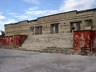
Mitla is the second-most important archeological site in the state of Oaxaca in Mexico, and the most important of the Zapotec culture. The site is located 44 km from the city of Oaxaca, in the upper end of the Tlacolula Valley, one of the three cold, high valleys that form the Central Valleys Region of the state. At an elevation of 4,855 ft, surrounded by the mountains of the Sierra Madre del Sur, the archeological site is within the modern municipality of San Pablo Villa de Mitla. It is 24 mi (38 km) southeast of Oaxaca city. While Monte Albán was the most important politically of the Zapotec centers, Mitla became the main religious one in a later period as the area became dominated by the Mixtec.

Tourism in Mexico Overview of tourism in Mexico


Tourism in Mexico is a very important industry. Since the 1960s, it has been heavily promoted by the Mexican government, as "an industry without smokestacks." Mexico has traditionally been among the most visited countries in the world according to the World Tourism Organization, and it is the second-most visited country in the Americas, after the United States. In 2017, Mexico was ranked as the sixth-most visited country in the world for tourism activities. Mexico has a significant number of UNESCO World Heritage sites with the list including ancient ruins, colonial cities, and natural reserves, as well as a number of works of modern public and private architecture. Mexico has attracted foreign visitors beginning in the early nineteenth century, cultural festivals, colonial cities, nature reserves and the beach resorts. The nation's temperate climate and unique culture – a fusion of the European and the Mesoamerican are attractive to tourists. The peak tourism seasons in the country are during December and the mid-Summer, with brief surges during the week before Easter and Spring break, when many of the beach resort sites become popular destinations for college students from the United States.

Tonalá, Jalisco

Tonalá is a city and municipality within the Guadalajara Metropolitan Area in the state of Jalisco in Mexico. With a population of 374,258, it is the fourth largest city in the state, the other three being the other major population centres in the metro area: Guadalajara, Zapopan, and Tlaquepaque. It is best known as a major handcrafts center for Jalisco, especially pottery, as well as its very large Thursday and Sunday street market, dedicated to handcrafts.

El Palmillo is a Mesoamerican Classic Period archaeological site located in the Valley of Oaxaca, associated with the pre-Columbian Zapotec civilization which was centered in the valley and the surrounding highlands of the present-day state of Oaxaca, Mexico. Located on a hilltop in the eastern Tlacolula arm of the valley, El Palmillo is just to the south of the pre-Columbian site of Mitla and to the east of the major Zapotec regional center, Monte Albán.

Zapotec languages Group of related indigenous Mesoamerican languages

The Zapotec languages are a group of around 50 closely related indigenous Mesoamerican languages that constitute a main branch of the Oto-Manguean language family and which is spoken by the Zapotec people from the southwestern-central highlands of Mexico. A 2020 census reports nearly half a million speakers, with the majority inhabiting the state of Oaxaca. Zapotec-speaking communities are also found in the neighboring states of Puebla, Veracruz, and Guerrero. Labor migration has also brought a number of native Zapotec speakers to the United States, particularly in California and New Jersey. Most Zapotec-speaking communities are highly bilingual in Spanish.

Santa Cruz Xoxocotlán City and municipality in Oaxaca, Mexico

Santa Cruz Xoxocotlán is a small city and municipality located 5 km from the state capital of Oaxaca in the south of Mexico. It is part of the Centro District in the Valles Centrales region. The name comes from the Nahuatl word “xocotl” which means “sour or sweet and sour fruit” with the duplicative “xo” to indicate “very.” The meaning of the entire phrase means “among the very sour fruits.” The Mixtec name for the area was Nuunitatnohoyoo which mean “land of the moon-faced flowers.” However, the community is most commonly referred to simply as Xoxo.

Oaxaca Valley Valley in Mexico

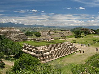
The Central Valleys of Oaxaca, also simply known as the Oaxaca Valley, is a geographic region located within the modern-day state of Oaxaca in southern Mexico. In an administrative context, it has been defined as comprising the districts of Etla, Centro, Zaachila, Zimatlán, Ocotlán, Tlacolula and Ejutla. The valley, which is located within the Sierra Madre Mountains, is shaped like a distorted and almost upside-down “Y,” with each of its arms bearing specific names: the northwestern Etla arm, the central southern Valle Grande, and the Tlacolula arm to the east. The Oaxaca Valley was home to the Zapotec civilization, one of the earliest complex societies in Mesoamerica, and the later Mixtec culture. A number of important and well-known archaeological sites are found in the Oaxaca Valley, including Monte Albán, Mitla, San José Mogote and Yagul. Today, the capital of the state, Oaxaca City, is located in the central portion of the valley.

San Jerónimo Tlacochahuaya Place in Oaxaca, Mexico

San Jerónimo Tlacochahuaya is a town and municipality in the Mexican state of Oaxaca, 21 km from the city of Oaxaca on Federal Highway 190 between Santa Maria del Tule and Mitla. It is part of the Tlacolula District in the east of the Valles Centrales Region. The name Tlacochahuaya comes from Nahuatl and means “in wet land” or “in the swamp.”

Tlacolula de Matamoros City & Municipality in Oaxaca, Mexico

Tlacolula de Matamoros is a city and municipality in the Mexican state of Oaxaca, about 30 km from the center of the city of Oaxaca on Federal Highway 190, which leads east to Mitla and the Isthmus of Tehuantepec. It is part of the Tlacolula District in the east of the Valles Centrales Region.

Yagul

Yagul is an archaeological site and former city-state associated with the Zapotec civilization of pre-Columbian Mesoamerica, located in the Mexican state of Oaxaca. The site was declared one of the country's four Natural Monuments on 13 October 1998. The site is also known locally as Pueblo Viejo and was occupied at the time of the Spanish Conquest. After the Conquest the population was relocated to the nearby modern town of Tlacolula where their descendants still live.

San Bartolo Coyotepec Town & Municipality in Oaxaca, Mexico

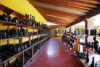
San Bartolo Coyotepec is a town and municipality located in the center of the Mexican state of Oaxaca. It is in the Centro District of the Valles Centrales region about fifteen km south of the capital of Oaxaca.

Villa de Zaachila Town & Municipality in Oaxaca, Mexico

Villa de Zaachila is a town and municipality in Oaxaca, Mexico, six km from Oaxaca City. It is part of the Zaachila District in the west of the Valles Centrales Region. In the pre-Hispanic era, it was the main city-state for the Valley of Oaxaca after the fall of Monte Albán, and the Zaachila Zapotecs were the prominent political force for much of the Valley of Oaxaca when the Spanish arrived. Since then, it has been mostly quiet, but political unrest has been prominent since 2006 and the municipality has two parallel governments.

Teotitlán del Valle Town & Municipality in Oaxaca, Mexico

Teotitlán del Valle is a small village and municipality located in the Tlacolula District in the east of the Valles Centrales Region, 31 km from the city of Oaxaca in the foothills of the Sierra Juárez mountains. It is part of the Tlacolula Valley district. It is known for its textiles, especially rugs, which are woven on hand-operated looms, from wool obtained from local sheep and dyed mainly with local, natural dyes. They combine historical Zapotec designs with contemporary designs such as reproductions of famous artists' work. Artists take commissions and participate in tours of family-owned workshops. The name Teotitlán comes from Nahuatl and means "land of the gods." Its Zapotec name is Xaguixe, which means "at the foot of the mountain." Established in 1465, it was one of the first villages founded by Zapotec peoples in this area and retains its Zapotec culture and language.

Tlacolula District District in Oaxaca, Mexico

Tlacolula District is located in the east of the Valles Centrales Region of the State of Oaxaca, Mexico.

According to the Mexican government agency Conapo, Oaxaca is the third most economically marginalized states in Mexico. The state has 3.3% of the population but produces only 1.5% of the GNP. The main reason for this is the lack of infrastructure and education, especially in the interior of the state outside of the capital. Eighty percent of the state's municipalities do not meet federal minimums for housing and education. Most development projects are planned for the capital and the surrounding area. Little has been planned for the very rural areas and the state lacks the resources to implement them. The largest sector of Oaxaca's economy is agriculture, mostly done communally in ejidos or similar arrangements. About 31% of the population is employed in agriculture, about 50% in commerce and services and 22% in industry. The commerce sector dominates the gross domestic product at 65.4%, followed by industry/mining at 18.9% and agriculture at 15.7%.

Oaxacan cuisine Regional cuisine of Oaxaca, Mexico

Oaxacan cuisine is a regional cuisine of Mexico, centered on the city of Oaxaca, the capital of the state of the same name located in southern Mexico. Oaxaca is one of Mexico's major gastronomic, historical, and gastro-historical centers whose cuisine is known internationally. Like the rest of Mexican cuisine, Oaxacan food is based on staples such as corn, beans and chile peppers, but there is a great variety of other ingredients and food preparations due to the influence of the state's varied geography and indigenous cultures. Corn and many beans were first cultivated in Oaxaca. Well known features of the cuisine include ingredients such as chocolate, Oaxaca cheese, mezcal and grasshoppers (chapulines) with dishes such as tlayudas, Oaxacan style tamales and seven notable varieties of mole sauce. The cuisine has been praised and promoted by food experts such as Diana Kennedy and Rick Bayless and is part of the state's appeal for tourists.

Güilá Zapotec(Zapoteco de San Pablo Güilá, Zapoteco de San Dionisio Ocotepec) is a Zapotec language of Oaxaca, Mexico. It is spoken in the town of San Pablo Güilá, Tlacolula District, Oaxaca, Mexico.

Handcrafts and folk art in Oaxaca

Oaxaca handcrafts and folk art is one of Mexico's important regional traditions of its kind, distinguished by both its overall quality and variety. Producing goods for trade has been an important economic activity in the state, especially in the Central Valleys region since the pre-Hispanic era which the area laid on the trade route between central Mexico and Central America. In the colonial period, the Spanish introduced new raw materials, new techniques and products but the rise of industrially produced products lowered the demand for most handcrafts by the early 20th century. The introduction of highways in the middle part of the century brought tourism to the region and with it a new market for traditional handcrafts. Today, the state boasts the largest number of working artisans in Mexico, producing a wide range of products that continue to grow and evolve to meet changing tastes in the market.

References

  1. 1 2 3 4 5 6 7 8 9 10 11 12 13 "Enciclopedia de los Municipios de México Oaxaca Teotitlán del Valle" (in Spanish). Mexico: INAFED. Archived from the original on July 22, 2011. Retrieved December 10, 2009.
  2. 1 2 3 4 5 6 7 8 Olmedo, Jesus (2009-03-11). "Niega Gertz Manero saqueo al Museo Frissell de Mitla" [Gertz Manero denies sacking the Frissell Museum of Mitla]. Info Minuto (in Spanish). Mexico. Retrieved 2009-12-10.[ permanent dead link ]
  3. 1 2 3 4 "Mitla: ciudad de los muertos" [Mitla:City of the Dead] (in Spanish). Retrieved December 10, 2009.
  4. "Cultura" [Culture] (in Spanish). Mitla, Oaxaca: Municipality of San Pablo Villa de Mitla. Archived from the original on April 26, 2009. Retrieved December 10, 2009.
  5. "Mercado de Artesanías de Mitla" [Handcrafts Market of Mitla] (in Spanish). Mexico: Travel by Mexico. Retrieved December 10, 2009.
  6. 1 2 Mullen, Robert James (2002). Architecture and its sculpture in viceregal Mexico. Austin, Texas: University of Texas Press. pp. 72–73. ISBN   0-292-75210-5 . Retrieved December 10, 2009.
  7. Santos in Oaxaca's Ancient Churches: San Pablo Mitla Archived 2012-07-19 at archive.today . Retrieved 2012-04-13.
  8. 1 2 3 4 5 Ramirez, Francisco (2009-11-23). "Mitla, Una Opción Turística Desaprovechada" [Mitla, an option not taken advantage of] (in Spanish). Oaxaca, Mexico: RIOaxaca. Retrieved 2009-12-10.[ permanent dead link ]
  9. 1 2 3 4 5 6 Mendoza, Elizabeth (2008-06-17). "Saqueo impune al museo de Frissell de Mitla" [Sacking with impunity of the Frissell Museum of Mitla] (in Spanish). El Piñero de la Cuenca. Retrieved 2009-12-10.
  10. 1 2 3 "INEGI Census 2005" (in Spanish). Archived from the original on June 13, 2011. Retrieved December 10, 2009.
  11. "Importante hallazgo del pasado prehispánico en Oaxaca" [Important find from the pre-Hispanic past in Oaxaca]. El Informador (in Spanish). Guadalajara, Mexico. 2009-05-07. Retrieved 2009-12-10.
  12. Charles McNett, "The Chirimia: A Latin American Shawm," The Galpin Society Journal 13 (1960): 44-51
  13. Quintanar Hinojosa, Beatriz (August 2007). "Ciudad de Oaxaca". Guía México Desconocido: Oaxaca. 137.
  14. León, Andrea (2009-10-25). "Villa de Mitla recibirá a sus muertos; anuncian festejos" [The village of Mitla will welcome its dead, announce festivals]. Diario Despertar (in Spanish). Oaxaca, Mexico. Archived from the original on 2011-07-22. Retrieved 2009-12-10.
  15. Trejo, Natalia (30 September 2019). "Mama Rabbit Bar's Bricia Lopez on thriving in the mezcal industry". HOLA! USA. Retrieved 2 January 2020.

Coordinates: 16°55′N96°24′W / 16.917°N 96.400°W / 16.917; -96.400