
La Magdalena Contreras is a borough in the Mexico City. As of the 2010 census, it has a population of 239,086 inhabitants and is the third-least populous of Mexico City's boroughs. It lies at an elevation of 2,365 m (7,759 ft) above sea level. It is named after two historically important communities—La Magdalena Atlitic and Colonia Contreras. The northern end of the borough is urbanized. The rest of Magdalena Contreras, with its mountains and ravines, is designated as a conservation zone. However, urban sprawl has put pressure on these conservation areas. In an effort to preserve the area's forests and natural resources, the borough government has started promoting ecotourism.
San Dionisio is the Spanish-language version of Saint Dionysius. It may refer to:

Totontepec Villa de Morelos is a town and municipality, in the Sierra Mixe district of the Mexican state of Oaxaca. It is located 1,840 meters above sea level and 146 kilometers from the state capital, Oaxaca de Juárez. The toponym "Totontepec" is of Nahuatl origin, meaning "hot hill". In the local dialect of Mixe the town is called Anyukojm, meaning "place of thunder."

Ocotepec is a small town to the north of the city of Cuernavaca, but within the municipality of Cuernavaca, Mexico. The name Ocotepec means “on the hill of the ocotes, or Montezuma pines.” It is located only minutes from the center of Cuernavaca on the highway that leads to Tepoztlán. The community is divided into four neighborhoods based on the major churches in town, which is an organization left over from the colonial period. The four neighborhoods are Candelaria, Dolores, Ramos, and Santa Cruz, each with its own patron saint and feast day. This organization is part of the reason why this community has managed to maintain more ancient traditions, a number of which date from the pre-Hispanic period. Ocotepec is one of the most traditional communities in the municipality of Cuernavaca. On the main road through town, there are dozens of stores specializing in handcrafted clay, stone and wood pieces, as well as rustic furniture. Among these shops are restaurants and food stalls specializing in barbacoa and cecina.

Tlaxiaco is a city, and its surrounding municipality of the same name, in the Mexican state of Oaxaca. It is located in the Tlaxiaco District in the south of the Mixteca Region, with a population of about 17,450.
Tejupilco de Hidalgo is the seat of Tejupilco Municipality in the State of Mexico, Mexico. It is located approximately 100 kilometres (62 mi) southwest of the state capital Toluca, along Federal Highway 34. The name Tejupilco comes from Náhuatl meaning "between the toes". "De Hidalgo" was added to honor Father Miguel Hidalgo who initiated the Mexican War of Independence.
Tejupilco is a municipality in the State of Mexico, Mexico, located approximately 100 kilometres (62 mi) southwest of the state capital Toluca, along Federal Highway 134. Its municipal seat is Tejupilco de Hidalgo. The municipality has a total area of about 1,327 km2 (512 sq mi), with a contrasting topography ranging from deep ravines and canyons to high ridges; the highest elevation within the municipality reaches some 1,117 metres (3,660 ft) asl. The 2005 census recorded a population of 62,547 inhabitants.
Pied-piping with inversion is a special word order phenomenon found in some languages, such as those in the Mesoamerican linguistic area.

Ocotepec is a town and municipality in the Mexican state of Chiapas in southern Mexico.
San Dionisio del Mar is a town and municipality in Oaxaca in south-western Mexico. It is part of the Juchitán District in the east of the Istmo de Tehuantepec region. The town is named after its patron saint.
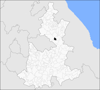
San Dionisio Ocotlan is a town and municipality in Oaxaca in south-western Mexico. The municipality covers an area of 20.41 km2. It is part of the Ocotlán District in the south of the Valles Centrales Region
San Mateo del Mar is a coastal town and municipality in Oaxaca in south-western Mexico. It is part of the Tehuantepec District in the west of the Istmo Region. It is the largest of four Huave towns in the region, the others being San Dionisio del Mar, San Francisco del Mar and Santa María del Mar.
San Pedro Ocotepec is a town and municipality in Oaxaca in south-western Mexico. The municipality covers an area of 136.51 km². It is part of the Sierra Mixe district within the Sierra Norte de Oaxaca Region.
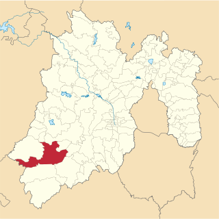
Santo Tomás Ocotepec is a town and municipality in Oaxaca in south-western Mexico. The municipality covers an area of km². It is part of the Tlaxiaco District in the south of the Mixteca Region.
Ocotepec (municipality) is a town and municipality in the Mexican state of Puebla in south-eastern Mexico.

Santa Maria Ahuacatitlán is a village in the municipality of Cuernavaca, in the state of Morelos, Mexico. Ahuacatitlán means "place among aguacates" (avocados).

Tlacolula District is located in the east of the Valles Centrales Region of the State of Oaxaca, Mexico.
Tlaxiaco District is located in the south of the Mixteca Region of the State of Oaxaca, Mexico. The main city is the Heroic City of Tlaxiaco
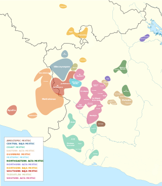
The internal classification of Mixtec is controversial. Many varieties are mutually unintelligible and by that criterion separate languages. In the 16th century, Spanish authorities recognized half a dozen lenguas comprising the Mixtec lengua. It is not clear to what extent these were distinct languages at the time. Regardless, the colonial disintegration of the Mixtec nation and resulting isolation of local communities led to the rapid diversification of local dialects into distinct languages. Below are some attempts at Mixtec classification by various scholars.
Güilá Zapotec(Zapoteco de San Pablo Güilá, Zapoteco de San Dionisio Ocotepec) is a Zapotec language of Oaxaca, Mexico. It is spoken in the town of San Pablo Güilá, Tlacolula District, Oaxaca, Mexico.

