
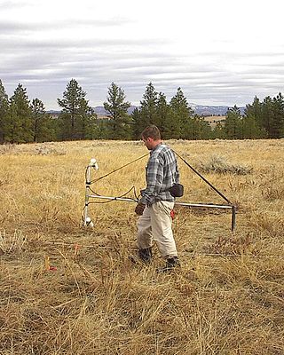
A magnetometer is a device that measures magnetic field or magnetic dipole moment. Different types of magnetometers measure the direction, strength, or relative change of a magnetic field at a particular location. A compass is one such device, one that measures the direction of an ambient magnetic field, in this case, the Earth's magnetic field. Other magnetometers measure the magnetic dipole moment of a magnetic material such as a ferromagnet, for example by recording the effect of this magnetic dipole on the induced current in a coil.

A metal detector is an instrument that detects the nearby presence of metal. Metal detectors are useful for finding metal objects on the surface, underground, and under water. A metal detector consists of a control box, an adjustable shaft, and a variable-shaped pickup coil. When the coil nears metal, the control box signals its presence with a tone, light, or needle movement. Signal intensity typically increases with proximity. A common type are stationary "walk through" metal detectors used at access points in prisons, courthouses, airports and psychiatric hospitals to detect concealed metal weapons on a person's body.
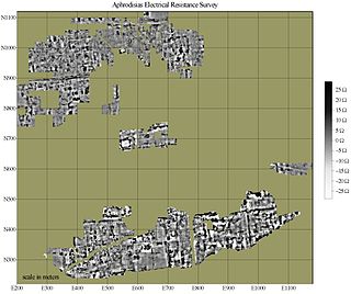
In archaeology, geophysical survey is ground-based physical sensing techniques used for archaeological imaging or mapping. Remote sensing and marine surveys are also used in archaeology, but are generally considered separate disciplines. Other terms, such as "geophysical prospection" and "archaeological geophysics" are generally synonymous.

Prospecting is the first stage of the geological analysis of a territory. It is the search for minerals, fossils, precious metals, or mineral specimens. It is also known as fossicking.

An anti-submarine weapon (ASW) is any one of a number of devices that are intended to act against a submarine and its crew, to destroy (sink) the vessel or reduce its capability as a weapon of war. In its simplest sense, an anti-submarine weapon is usually a projectile, missile or bomb that is optimized to destroy submarines.
Marine geology or geological oceanography is the study of the history and structure of the ocean floor. It involves geophysical, geochemical, sedimentological and paleontological investigations of the ocean floor and coastal zone. Marine geology has strong ties to geophysics and to physical oceanography.
Exploration geophysics is an applied branch of geophysics and economic geology, which uses physical methods at the surface of the Earth, such as seismic, gravitational, magnetic, electrical and electromagnetic, to measure the physical properties of the subsurface, along with the anomalies in those properties. It is most often used to detect or infer the presence and position of economically useful geological deposits, such as ore minerals; fossil fuels and other hydrocarbons; geothermal reservoirs; and groundwater reservoirs. It can also be used to detect the presence of unexploded ordnance.

Anti-submarine warfare is a branch of underwater warfare that uses surface warships, aircraft, submarines, or other platforms, to find, track, and deter, damage, or destroy enemy submarines. Such operations are typically carried out to protect friendly shipping and coastal facilities from submarine attacks and to overcome blockades.
Geophysical survey is the systematic collection of geophysical data for spatial studies. Detection and analysis of the geophysical signals forms the core of Geophysical signal processing. The magnetic and gravitational fields emanating from the Earth's interior hold essential information concerning seismic activities and the internal structure. Hence, detection and analysis of the electric and Magnetic fields is very crucial. As the Electromagnetic and gravitational waves are multi-dimensional signals, all the 1-D transformation techniques can be extended for the analysis of these signals as well. Hence this article also discusses multi-dimensional signal processing techniques.

An aeromagnetic survey is a common type of geophysical survey carried out using a magnetometer aboard or towed behind an aircraft. The principle is similar to a magnetic survey carried out with a hand-held magnetometer, but allows much larger areas of the Earth's surface to be covered quickly for regional reconnaissance. The aircraft typically flies in a grid-like pattern with height and line spacing determining the resolution of the data.

In geophysics, a magnetic anomaly is a local variation in the Earth's magnetic field resulting from variations in the chemistry or magnetism of the rocks. Mapping of variation over an area is valuable in detecting structures obscured by overlying material. The magnetic variation in successive bands of ocean floor parallel with mid-ocean ridges was important evidence for seafloor spreading, a concept central to the theory of plate tectonics.
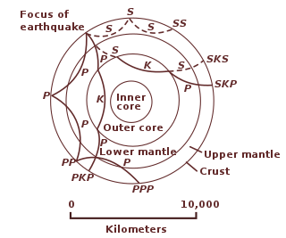
Geophysical MASINT is a branch of Measurement and Signature Intelligence (MASINT) that involves phenomena transmitted through the earth and manmade structures including emitted or reflected sounds, pressure waves, vibrations, and magnetic field or ionosphere disturbances.
Ronald George Mason was one of the oceanographers whose pioneering Cold War geomagnetic survey work lead to the discovery of magnetic striping on the seafloor. First discovering magnetic stripes on the bottom of the Pacific Ocean off the United States West Coast, he later also identified them around the Mid-Atlantic Ridge.
Victor Vacquier Sr. was a professor of geophysics at the Scripps Institution of Oceanography at the University of California, San Diego.
Magnetic surveying is one of a number of methods used in archaeological geophysics. Magnetic surveys record spatial variation in the Earth's magnetic field. In archaeology, magnetic surveys are used to detect and map archaeological artefacts and features. Magnetic surveys are used in both terrestrial and marine archaeology.

Near-surface geophysics is the use of geophysical methods to investigate small-scale features in the shallow subsurface. It is closely related to applied geophysics or exploration geophysics. Methods used include seismic refraction and reflection, gravity, magnetic, electric, and electromagnetic methods. Many of these methods were developed for oil and mineral exploration but are now used for a great variety of applications, including archaeology, environmental science, forensic science, military intelligence, geotechnical investigation, treasure hunting, and hydrogeology. In addition to the practical applications, near-surface geophysics includes the study of biogeochemical cycles.
Underwater searches are procedures to find a known or suspected target object or objects in a specified search area under water. They may be carried out underwater by divers, manned submersibles, remotely operated underwater vehicles, or autonomous underwater vehicles, or from the surface by other agents, including surface vessels, aircraft and cadaver dogs.
The following outline is provided as an overview of and topical guide to geophysics:
Geophysical signal analysis is concerned with the detection and a subsequent processing of signals. Any signal which is varying conveys valuable information. Hence to understand the information embedded in such signals, we need to 'detect' and 'extract data' from such quantities. Geophysical signals are of extreme importance to us as they are information bearing signals which carry data related to petroleum deposits beneath the surface and seismic data. Analysis of geophysical signals also offers us a qualitative insight into the possibility of occurrence of a natural calamity such as earthquakes or volcanic eruptions.
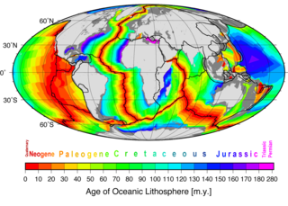
Marine geophysics is the scientific discipline that employs methods of geophysics to study the world's ocean basins and continental margins, particularly the solid earth beneath the ocean. It shares objectives with marine geology, which uses sedimentological, paleontological, and geochemical methods. Marine geophysical data analyses led to the theories of seafloor spreading and plate tectonics.


